File:Bistum Konstanz.jpg
Bistum_Konstanz.jpg (428 × 600 pixels, file size: 175 KB, MIME type: image/jpeg)
Captions
Captions
Summary[edit]
| Description | |||
| Date | Grenzen bis ca. 1801 | ||
| Source | evtl. Erzbischöfliches Archiv Freiburg | ||
| Author | Scanned and modified by de:Benutzer:Eruedin. | ||
| Other versions |
|


Licensing[edit]
|
This work is in the public domain in its country of origin and other countries and areas where the copyright term is the author's life plus 70 years or fewer.
| |
| This file has been identified as being free of known restrictions under copyright law, including all related and neighboring rights. | |
Achtung: Diese Karte ist nicht gemeinfrei. Sie entstammt dem Werk "Erzdiözese Freiburg, Das Erzbistum Freiburg: 1827-1977, 3. Auflage 1978". Die Rechte liegen beim Herder-Verlag in Freiburg. Es handelt sich nicht um eine alte Karte, der Autor ist noch nicht 75 Jahre verstorben. Ich kann vor der Verwendung der Karte nur warnen.
File history
Click on a date/time to view the file as it appeared at that time.
| Date/Time | Thumbnail | Dimensions | User | Comment | |
|---|---|---|---|---|---|
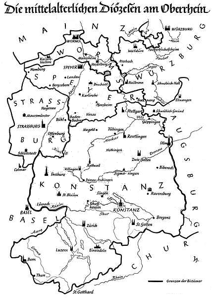
| current | 00:31, 7 February 2006 | | 428 × 600 (175 KB) | Fb78 (talk | contribs) | Map of the medieval dioceses of Konstanz, Speyer, Strasbourg, Worms, and partly Würzburg, Mainz, Augsburg, Basel, Chur. Category:Historical maps of Europe Category:Roman Catholicism |
You cannot overwrite this file.
File usage on Commons
The following page uses this file:
File usage on other wikis
The following other wikis use this file:
- Usage on als.wikipedia.org
- Usage on bg.wikipedia.org
- Usage on cs.wikipedia.org
- Usage on de.wikipedia.org
- Usage on en.wikipedia.org
- Usage on eo.wikipedia.org
- Usage on es.wikipedia.org
- Usage on fr.wikipedia.org
- Usage on it.wikipedia.org
- Usage on pfl.wikipedia.org
- Usage on pl.wikipedia.org
- Usage on ru.wikipedia.org