File:Blue Hills (WA) psdem.jpg
Jump to navigation
Jump to search
No higher resolution available.
Blue_Hills_(WA)_psdem.jpg (658 × 458 pixels, file size: 45 KB, MIME type: image/jpeg)
Captions
Captions
Add a one-line explanation of what this file represents
Summary[edit]
_psdem.jpg&action=edit§ion=1)
| Description |
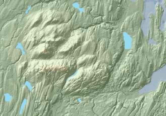
English: Lidar-based shaded-relief image of the Blue Hills, Kitsap County, Washington, and adjacent areas, including part of City of Bremerton. |
| Date | |
| Source | Excerpted from data assembled by David Finlayson et al. and released under Creative Commons license CC-by-2.0. See Combined Bathymetry and Topography DEM of Western Washington State. University of Washington (2000). Archived from the original on 2006-02-13. Retrieved on 2014-10-24. |
| Author | Original imagery by Finlayson et al. 2000 |
| Permission (Reusing this file) |
This file is licensed under the Creative Commons Attribution 2.0 Generic license.
|
Licensing[edit]
_psdem.jpg&action=edit§ion=2)
This file is licensed under the Creative Commons Attribution 3.0 Unported license.
- You are free:
- to share – to copy, distribute and transmit the work
- to remix – to adapt the work
- Under the following conditions:
- attribution – You must give appropriate credit, provide a link to the license, and indicate if changes were made. You may do so in any reasonable manner, but not in any way that suggests the licensor endorses you or your use.
File history
Click on a date/time to view the file as it appeared at that time.
| Date/Time | Thumbnail | Dimensions | User | Comment | |
|---|---|---|---|---|---|
| current | 21:28, 24 October 2014 | | 658 × 458 (45 KB) | J. Johnson (talk | contribs) | {{Information |Description ={{en|1=Lidar-based shaded-relief image of the Blue Hills, Kitsap County, Washington, and adjacent areas, including part of City of Bremerton.}} |Source =Eexcerpted from data assembled by David Finlayson et al. and... |
You cannot overwrite this file.
File usage on Commons
There are no pages that use this file.
File usage on other wikis
The following other wikis use this file:
- Usage on en.wikipedia.org
_psdem.jpg&oldid=826721784)