File:Bottoms Road Bridge, Skidby - geograph.org.uk - 624349.jpg
Jump to navigation
Jump to search
No higher resolution available.
Bottoms_Road_Bridge,_Skidby_-_geograph.org.uk_-_624349.jpg (640 × 442 pixels, file size: 87 KB, MIME type: image/jpeg)
Captions
Captions
Add a one-line explanation of what this file represents
Summary[edit]
| Description |
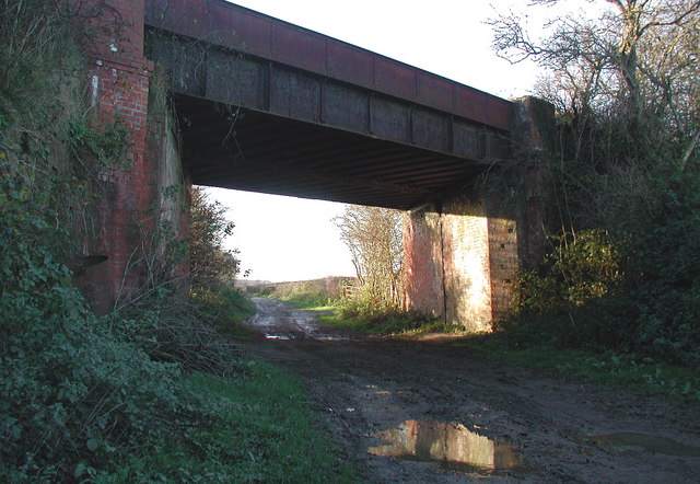
English: Bottoms Road Bridge, Skidby, East Riding of Yorkshire, England. Railway bridge where the dismantled Hull & Barnsley Railway crosses Riplingham Road in the Rush Hill valley, west of Skidby. This stretch of Riplingham Road was presumably known as Bottoms Road at some point. The Hull & Barnsley Railway was built in the 1880s together with the Alexandra Dock in Hull, to break the monopoly of the North Eastern Railway Company and provide an additional trading route inland from the busy Humber port. The railway didn't last long. Services west of South Howden station were withdrawn from 1st January 1932 and the regular service between Hull and South Howden ended on 30th July 1955, although some excursion traffic continued to use the line until about 1958. After that only a short section remained in Hull serving the local chemical works until the 1970s when another short stretch of the line just south of Selby was reopened for delivering coal to the newly built Drax Power Station. |
| Date | |
| Source | From geograph.org.uk |
| Author | Paul Glazzard |
| Permission (Reusing this file) |
Creative Commons Attribution Share-alike license 2.0 |
| Attribution (required by the license) | Paul Glazzard / Bottoms Road Bridge, Skidby / |
| Camera location | | View this and other nearby images on: OpenStreetMap |
|---|
_heading:270.00&language=en)
| Object location | | View this and other nearby images on: OpenStreetMap |
|---|
_heading:270.00&language=en)
Licensing[edit]

|
This image was taken from the Geograph project collection. See this photograph's page on the Geograph website for the photographer's contact details. The copyright on this image is owned by Paul Glazzard and is licensed for reuse under the Creative Commons Attribution-ShareAlike 2.0 license.
|
This file is licensed under the Creative Commons Attribution-Share Alike 2.0 Generic license.
Attribution: Paul Glazzard
- You are free:
- to share – to copy, distribute and transmit the work
- to remix – to adapt the work
- Under the following conditions:
- attribution – You must give appropriate credit, provide a link to the license, and indicate if changes were made. You may do so in any reasonable manner, but not in any way that suggests the licensor endorses you or your use.
- share alike – If you remix, transform, or build upon the material, you must distribute your contributions under the same or compatible license as the original.
File history
Click on a date/time to view the file as it appeared at that time.
| Date/Time | Thumbnail | Dimensions | User | Comment | |
|---|---|---|---|---|---|
| current | 05:20, 7 February 2011 | | 640 × 442 (87 KB) | GeographBot (talk | contribs) | == {{int:filedesc}} == {{Information |description={{en|1=Bottoms Road Bridge, Skidby Railway bridge where the dismantled Hull & Barnsley Railway crosses Riplingham Road in the Rush Hill valley, west of Skidby. This stretch of Riplingham Road was presumabl |
You cannot overwrite this file.
File usage on Commons
There are no pages that use this file.