File:Bridges over the River Tweed at Leaderfoot - geograph.org.uk - 585356.jpg
Jump to navigation
Jump to search
No higher resolution available.
Bridges_over_the_River_Tweed_at_Leaderfoot_-_geograph.org.uk_-_585356.jpg (627 × 424 pixels, file size: 138 KB, MIME type: image/jpeg)
Captions
Captions
Add a one-line explanation of what this file represents
Summary[edit]
| Description |
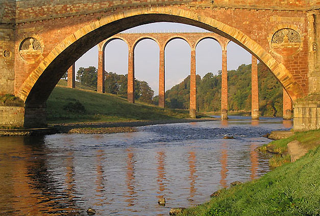
English: Bridges over the River Tweed at Leaderfoot The Drygrange Viaduct is framed by the 31m central span of Drygrange Old Bridge at Leaderfoot in early morning October sunshine. The viaduct took two years to build and was opened in 1865 for the Berwickshire Railway which ran from St Boswells to Reston. It has nineteen slender piers, the tallest being 37m above the River Tweed. The Berwickshire Line was closed in 1948 but the bridge is in the care of Historic Scotland. Drygrange Old Bridge (1778-80)is a three-arched stone bridge that is now closed to vehicular traffic. Road traffic is now taken by a reinforced concrete and steel box girder bridge (1971-73) a short distance downstream from this viewpoint.
(Source: Borders and Berwick, An Architectural Guide by Charles Alexander Strang). |
| Date | |
| Source | From geograph.org.uk |
| Author | Walter Baxter |
| Attribution (required by the license) | Walter Baxter / Bridges over the River Tweed at Leaderfoot / |
| Camera location | | View this and other nearby images on: OpenStreetMap |
|---|
_heading:270.00&language=en)
| Object location | | View this and other nearby images on: OpenStreetMap |
|---|
_heading:270.00&language=en)
Licensing[edit]

|
This image was taken from the Geograph project collection. See this photograph's page on the Geograph website for the photographer's contact details. The copyright on this image is owned by Walter Baxter and is licensed for reuse under the Creative Commons Attribution-ShareAlike 2.0 license.
|
This file is licensed under the Creative Commons Attribution-Share Alike 2.0 Generic license.
Attribution: Walter Baxter
- You are free:
- to share – to copy, distribute and transmit the work
- to remix – to adapt the work
- Under the following conditions:
- attribution – You must give appropriate credit, provide a link to the license, and indicate if changes were made. You may do so in any reasonable manner, but not in any way that suggests the licensor endorses you or your use.
- share alike – If you remix, transform, or build upon the material, you must distribute your contributions under the same or compatible license as the original.
File history
Click on a date/time to view the file as it appeared at that time.
| Date/Time | Thumbnail | Dimensions | User | Comment | |
|---|---|---|---|---|---|
| current | 13:16, 6 February 2011 | | 627 × 424 (138 KB) | GeographBot (talk | contribs) | == {{int:filedesc}} == {{Information |description={{en|1=Bridges over the River Tweed at Leaderfoot The Drygrange Viaduct is framed by the 31m central span of Drygrange Old Bridge at Leaderfoot in early morning October sunshine. The viaduct took two years |
You cannot overwrite this file.
File usage on Commons
There are no pages that use this file.