File:Bronze Plaque on the Northwest Corner of the Bridge. - Riverside Bridge, Spanning Truckee River at Booth Street, Reno, Washoe County, NV HAER NEV,16-RENO,2-7.tif
Jump to navigation
Jump to search

Size of this JPG preview of this TIF file: 756 × 600 pixels. Other resolutions: 303 × 240 pixels | 605 × 480 pixels | 968 × 768 pixels | 1,280 × 1,015 pixels | 2,560 × 2,031 pixels | 5,000 × 3,966 pixels.
Original file (5,000 × 3,966 pixels, file size: 18.91 MB, MIME type: image/tiff)
Captions
Captions
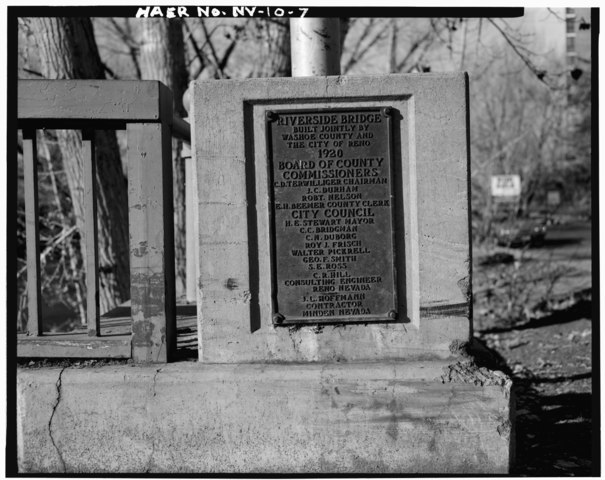
Bronze plaque at Booth Street Bridge
Summary[edit]
| Bronze Plaque on the Northwest Corner of the Bridge. - Riverside Bridge, Spanning Truckee River at Booth Street, Reno, Washoe County, NV | ||||
|---|---|---|---|---|
| Photographer |
Related names:
|
|||
| Title |
Bronze Plaque on the Northwest Corner of the Bridge. - Riverside Bridge, Spanning Truckee River at Booth Street, Reno, Washoe County, NV |
|||
| Depicted place | Nevada; Washoe County; Reno | |||
| Date | Documentation compiled after 1968 | |||
| Dimensions | 4 x 5 in. | |||
| Current location |
Library of Congress Prints and Photographs Division Washington, D.C. 20540 USA http://hdl.loc.gov/loc.pnp/pp.print |
|||
| Accession number |
HAER NEV,16-RENO,2-7 |
|||
| Credit line |
|
|||
| Notes |
|
|||
| Source | https://www.loc.gov/pictures/item/nv0110.photos.104280p | |||
| Permission (Reusing this file) |
|
|||

| Object location | | View this and other nearby images on: OpenStreetMap |
|---|
File history
Click on a date/time to view the file as it appeared at that time.
| Date/Time | Thumbnail | Dimensions | User | Comment | |
|---|---|---|---|---|---|
| current | 01:18, 29 July 2014 |  | 5,000 × 3,966 (18.91 MB) | Fæ (talk | contribs) | GWToolset: Creating mediafile for Fæ. HABS 24 July 2014 (2301:2600) |
You cannot overwrite this file.
File usage on Commons
The following page uses this file: