File:Bunkhouse East Elevation-Bunkhouse Plan-West Dugout North Elevation-West Dugout Plan - Grand Gulch Mine, Littlefield, Mohave County, AZ HAER AZ-78 (sheet 5 of 8).png

Original file (14,400 × 9,600 pixels, file size: 3.11 MB, MIME type: image/png)
Captions
Captions
| This image is a JPEG version of the original TIF image at File: Bunkhouse East Elevation-Bunkhouse Plan-West Dugout North Elevation-West Dugout Plan - Grand Gulch Mine, Littlefield, Mohave County, AZ HAER AZ-78 (sheet 5 of 8).tif.
However, any edits to the image should be based on the original TIF version in order to prevent generation loss, and both versions should be updated. Do not make edits based on this version. |
Summary[edit]
| Warning | The original file is very high-resolution. It might not load properly or could cause your browser to freeze when opened at full size. |
|---|
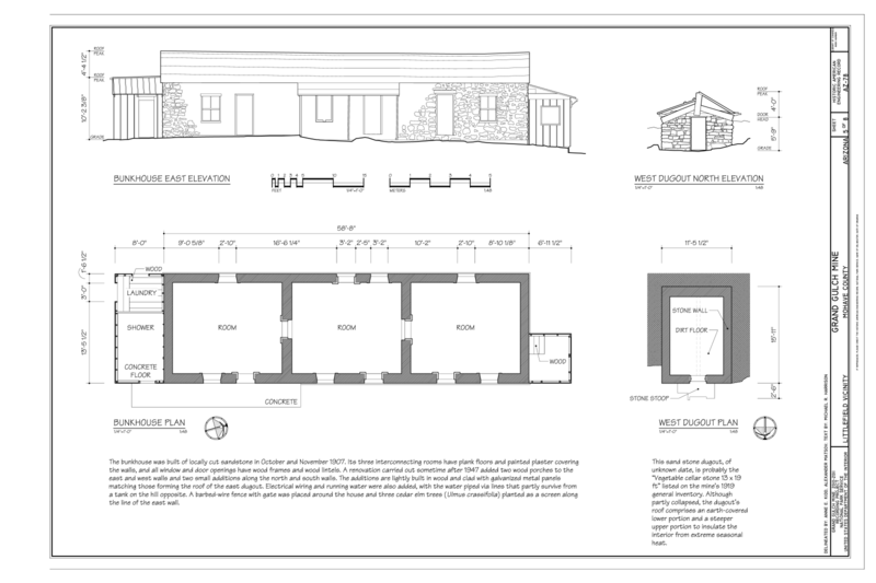
| Bunkhouse East Elevation
Bunkhouse Plan West Dugout North Elevation West Dugout Plan - Grand Gulch Mine, Littlefield, Mohave County, AZ |
||||
|---|---|---|---|---|
| Photographer |
Matsov, Alexander, creator |
|||
| Title |
Bunkhouse East Elevation Bunkhouse Plan West Dugout North Elevation West Dugout Plan - Grand Gulch Mine, Littlefield, Mohave County, AZ |
|||
| Depicted place | Arizona; Mohave County; Littlefield | |||
| Date | 2011 | |||
| Dimensions | 24 x 36 in. (D size) | |||
| Current location |
Library of Congress Prints and Photographs Division Washington, D.C. 20540 USA http://hdl.loc.gov/loc.pnp/pp.print |
|||
| Accession number |
HAER AZ-78 (sheet 5 of 8) |
|||
| Credit line |
|
|||
| Notes |
The Grand Gulch Mine represents the challenges small late-nineteenth- and early-twentieth-century mine companies faced when trying to exploit economic minerals in isolated and inhospitable areas of the desert and mountain west. Burdened by a remote site where even water had to be hauled in but emboldened by the promise of profitable returns, the mine's owners consistently sought to improve the transportation connections that linked the mine to its suppliers and markets. Their efforts relied on regional railroad development, which gradually reduced the difficult wagon haul to about 140 miles in 1899, 73 miles in 1905, and finally to 45 miles in 1912, at each step decreasing the cost of freighting and expanding the range of ore grades the mine could economically send to market. The mine lies within Grand Canyon-Parashant National Monument. The original 20.66-acre Adam Lode mining claim, officially located June 23, 1873, and patented October 5, 1883, remains in private hands at the heart of the site. The balance of the mine is on public land and is managed by the Bureau of Land Management in cooperation with the National Park Service.
|
|||
| References |
Related names:
|
|||
| Source | https://www.loc.gov/pictures/item/az0616.sheet.00005a | |||
| Permission (Reusing this file) |
|
|||
| Other versions |
.png) .png) .png) .png) .png) .png) |
|||

.png&action=edit§ion=1)
| Object location | | View this and other nearby images on: OpenStreetMap |
|---|
.png¶ms=036.887220_N_-113.928890_E_globe:Earth_class:object_type:object__&language=en)
File history
Click on a date/time to view the file as it appeared at that time.
| Date/Time | Thumbnail | Dimensions | User | Comment | |
|---|---|---|---|---|---|
| current | 08:57, 3 July 2014 | | 14,400 × 9,600 (3.11 MB) | Fæ (talk | contribs) | {{Compressed version|file=File:Bunkhouse_East_Elevation-Bunkhouse_Plan-West_Dugout_North_Elevation-West_Dugout_Plan_-_Grand_Gulch_Mine,_Littlefield,_Mohave_County,_AZ_HAER_AZ-78_(sheet_5_of_8).tif|thumb=nothumb}} =={{int:filedesc}}== {{Photograph | a... |
You cannot overwrite this file.
File usage on Commons
The following 16 pages use this file:
- File:1912 Grand Gulch Mine Vicinity Transportation Routes - Grand Gulch Mine, Littlefield, Mohave County, AZ HAER AZ-78 (sheet 2 of 8).png
- File:1912 Grand Gulch Mine Vicinity Transportation Routes - Grand Gulch Mine, Littlefield, Mohave County, AZ HAER AZ-78 (sheet 2 of 8).tif
- File:Bunkhouse East Elevation-Bunkhouse Plan-West Dugout North Elevation-West Dugout Plan - Grand Gulch Mine, Littlefield, Mohave County, AZ HAER AZ-78 (sheet 5 of 8).png
- File:Bunkhouse East Elevation-Bunkhouse Plan-West Dugout North Elevation-West Dugout Plan - Grand Gulch Mine, Littlefield, Mohave County, AZ HAER AZ-78 (sheet 5 of 8).tif
- File:Grand Gulch Mine Site Plan - Grand Gulch Mine, Littlefield, Mohave County, AZ HAER AZ-78 (sheet 3 of 8).png
- File:Grand Gulch Mine Site Plan - Grand Gulch Mine, Littlefield, Mohave County, AZ HAER AZ-78 (sheet 3 of 8).tif
- File:Grand Gulch Mine Title Sheet - Grand Gulch Mine, Littlefield, Mohave County, AZ HAER AZ-78 (sheet 1 of 8).png
- File:Grand Gulch Mine Title Sheet - Grand Gulch Mine, Littlefield, Mohave County, AZ HAER AZ-78 (sheet 1 of 8).tif
- File:Headquarters North Elevation-Headquarters Plan-East Dugout North Elevation-East Dugout Plan - Grand Gulch Mine, Littlefield, Mohave County, AZ HAER AZ-78 (sheet 4 of 8).png
- File:Headquarters North Elevation-Headquarters Plan-East Dugout North Elevation-East Dugout Plan - Grand Gulch Mine, Littlefield, Mohave County, AZ HAER AZ-78 (sheet 4 of 8).tif
- File:Partial Subsurface Schematic Plan - Grand Gulch Mine, Littlefield, Mohave County, AZ HAER AZ-78 (sheet 8 of 8).png
- File:Partial Subsurface Schematic Plan - Grand Gulch Mine, Littlefield, Mohave County, AZ HAER AZ-78 (sheet 8 of 8).tif
- File:Powder House West Elevation-Powder House Plan-Blacksmith Shop East Elevation-Blacksmith Shop Plan-Wood Shed South Elevation-Week Shed Plan - Grand Gulch Mine, Littlefield, HAER AZ-78 (sheet 6 of 8).png
- File:Powder House West Elevation-Powder House Plan-Blacksmith Shop East Elevation-Blacksmith Shop Plan-Wood Shed South Elevation-Week Shed Plan - Grand Gulch Mine, Littlefield, HAER AZ-78 (sheet 6 of 8).tif
- File:Smelter- South Elevation, Plan A-A, East Elevation, Cutaway Axonometric - Grand Gulch Mine, Littlefield, Mohave County, AZ HAER AZ-78 (sheet 7 of 8).png
- File:Smelter- South Elevation, Plan A-A, East Elevation, Cutaway Axonometric - Grand Gulch Mine, Littlefield, Mohave County, AZ HAER AZ-78 (sheet 7 of 8).tif
.png)
.png)
.png&oldid=838582172)