File:Bush Barrow - geograph.org.uk - 1622275.jpg
Bush_Barrow_-_geograph.org.uk_-_1622275.jpg (640 × 480 pixels, file size: 76 KB, MIME type: image/jpeg)
Captions
Captions
Summary[edit]
| Description |
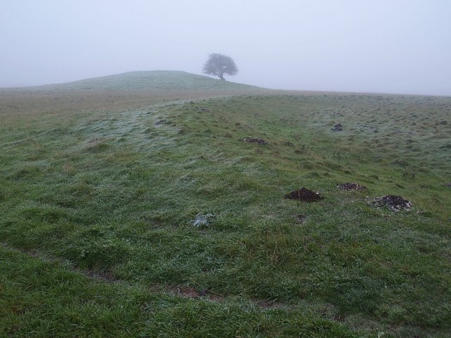
English: Bush Barrow "In the 1720s William Stukeley had called it the bush barrow after trees planted on the top (though the county people knew it as the green barrow)" http://www.britarch.ac.uk/ba/ba104/feat1.shtml .
"This very large bowl barrow in the Normanton Down barrow group, just south of Stonehenge, measures over 40m in diameter and stands today 3m high. It was excavated in 1808 by William Cunnington and Sir Richard Colt Hoare. The primary burial was of a tall, stout, adult man, buried lying on his back. The grave goods placed with him show that this was a princely burial from about 1900 -1700 B.C. It is Britain's richest and most important Bronze Age burial" http://www.wiltshireheritage.org.uk/galleries/index.php?Action=3&obID=89&prevID=9 . In the foreground is a round barrow. Together they form part of the Normanton Down Barrows. The first link gives much detail about the excavation of Bush Barrow and the site as a whole. |
| Date | |
| Source | From geograph.org.uk |
| Author | Derek Harper |
| Attribution (required by the license) | Derek Harper / Bush Barrow / |
| Camera location | | View this and other nearby images on: OpenStreetMap |
|---|
_heading:112.00&language=en)
| Object location | | View this and other nearby images on: OpenStreetMap |
|---|
_heading:112.00&language=en)
Licensing[edit]

|
This image was taken from the Geograph project collection. See this photograph's page on the Geograph website for the photographer's contact details. The copyright on this image is owned by Derek Harper and is licensed for reuse under the Creative Commons Attribution-ShareAlike 2.0 license.
|
- You are free:
- to share – to copy, distribute and transmit the work
- to remix – to adapt the work
- Under the following conditions:
- attribution – You must give appropriate credit, provide a link to the license, and indicate if changes were made. You may do so in any reasonable manner, but not in any way that suggests the licensor endorses you or your use.
- share alike – If you remix, transform, or build upon the material, you must distribute your contributions under the same or compatible license as the original.
File history
Click on a date/time to view the file as it appeared at that time.
| Date/Time | Thumbnail | Dimensions | User | Comment | |
|---|---|---|---|---|---|
| current | 12:33, 4 March 2011 | | 640 × 480 (76 KB) | GeographBot (talk | contribs) | == {{int:filedesc}} == {{Information |description={{en|1=Bush Barrow "In the 1720s William Stukeley had called it the bush barrow after trees planted on the top (though the county people knew it as the green barrow)" http://www.britarch.ac.uk/ |
You cannot overwrite this file.
File usage on Commons
The following page uses this file:
File usage on other wikis
The following other wikis use this file:
- Usage on de.wikipedia.org
- Usage on en.wikipedia.org
- Usage on hy.wikipedia.org
- Usage on it.wikipedia.org
- Usage on nl.wikipedia.org
- Usage on www.wikidata.org