File:CLOSE-UP VIEW OF ENTRANCE TO BUILDING NO. 33 AT KITCHEN WING FACING NORTH. VIEW SHOWS CONCRETE CANOPY OVERHANG ABOVE ENTRANCE. - U.S. Naval Base, Pearl Harbor, Marine Barracks, HABS HI,2-PEHA,40-6.tif
Jump to navigation
Jump to search

Size of this JPG preview of this TIF file: 759 × 599 pixels. Other resolutions: 304 × 240 pixels | 608 × 480 pixels | 973 × 768 pixels | 1,280 × 1,011 pixels | 2,560 × 2,022 pixels | 5,000 × 3,949 pixels.
Original file (5,000 × 3,949 pixels, file size: 18.83 MB, MIME type: image/tiff)
Captions
Captions
Add a one-line explanation of what this file represents
Summary[edit]
| CLOSE-UP VIEW OF ENTRANCE TO BUILDING NO. 33 AT KITCHEN WING FACING NORTH. VIEW SHOWS CONCRETE CANOPY OVERHANG ABOVE ENTRANCE. - U.S. Naval Base, Pearl Harbor, Marine Barracks, West Loch, B Avenue near Arizona Road, Pearl City, Honolulu County, HI | ||||
|---|---|---|---|---|
| Title |
CLOSE-UP VIEW OF ENTRANCE TO BUILDING NO. 33 AT KITCHEN WING FACING NORTH. VIEW SHOWS CONCRETE CANOPY OVERHANG ABOVE ENTRANCE. - U.S. Naval Base, Pearl Harbor, Marine Barracks, West Loch, B Avenue near Arizona Road, Pearl City, Honolulu County, HI |
|||
| Depicted place | Hawaii; Honolulu County; Pearl City | |||
| Date | Documentation compiled after 1933 | |||
| Dimensions | 4 x 5 in. | |||
| Current location |
Library of Congress Prints and Photographs Division Washington, D.C. 20540 USA http://hdl.loc.gov/loc.pnp/pp.print |
|||
| Accession number |
HABS HI,2-PEHA,40-6 |
|||
| Credit line |
|
|||
| Notes |
|
|||
| References |
|
|||
| Source | https://www.loc.gov/pictures/item/hi0291.photos.048348p | |||
| Permission (Reusing this file) |
|
|||

| Object location | | View this and other nearby images on: OpenStreetMap |
|---|
File history
Click on a date/time to view the file as it appeared at that time.
| Date/Time | Thumbnail | Dimensions | User | Comment | |
|---|---|---|---|---|---|
| current | 19:53, 11 July 2014 | 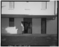 | 5,000 × 3,949 (18.83 MB) | Fæ (talk | contribs) | GWToolset: Creating mediafile for Fæ. HABS 11 July 2014 (1001:1200) |
You cannot overwrite this file.
File usage on Commons
The following page uses this file: