File:Calfreisen-Schanfigg-01.jpg
Jump to navigation
Jump to search

Size of this preview: 800 × 216 pixels. Other resolutions: 320 × 86 pixels | 640 × 173 pixels | 1,854 × 500 pixels.
Original file (1,854 × 500 pixels, file size: 1.03 MB, MIME type: image/jpeg)
Captions
Captions
Add a one-line explanation of what this file represents
Summary[edit]
| Description |
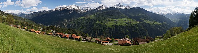
Beim Abstieg von Balnettis zum Schanfigger Dorf Calfreisen. Am südlichen Dorfrand die Ruine Bernegg. Weiter taleinwärts die Kirche von Castiel. Auf der gegenüberliegenden Talseite die Aroser Berge und an den Bergflanken des Gürgaletsch die Dörfer Tschiertschen und Praden. Aus 22 Hochformataufnahmen (2 Reihen à 11 Bilder) EXIF Daten: 23.05.2008 16:49:16 1/640 s - f/8 - ISO 200 - 60 mm Aufnahmestandort: oberhalb des Dorfes. 1304 m - 764428 / 190197 46° 50' 33.3" N, 9° 35' 40.2" E (46.842583°, 9.5945°) |
| Date | |
| Source | Own work |
| Author | Walter45 |
| Camera location | | View this and other nearby images on: OpenStreetMap |
|---|
Licensing[edit]
I, the copyright holder of this work, hereby publish it under the following licenses:

|
Permission is granted to copy, distribute and/or modify this document under the terms of the GNU Free Documentation License, Version 1.2 or any later version published by the Free Software Foundation; with no Invariant Sections, no Front-Cover Texts, and no Back-Cover Texts. A copy of the license is included in the section entitled GNU Free Documentation License. |
This file is licensed under the Creative Commons Attribution-Share Alike 3.0 Unported license.
- You are free:
- to share – to copy, distribute and transmit the work
- to remix – to adapt the work
- Under the following conditions:
- attribution – You must give appropriate credit, provide a link to the license, and indicate if changes were made. You may do so in any reasonable manner, but not in any way that suggests the licensor endorses you or your use.
- share alike – If you remix, transform, or build upon the material, you must distribute your contributions under the same or compatible license as the original.
You may select the license of your choice.
File history
Click on a date/time to view the file as it appeared at that time.
| Date/Time | Thumbnail | Dimensions | User | Comment | |
|---|---|---|---|---|---|
| current | 21:27, 23 May 2008 | 1,854 × 500 (1.03 MB) | Walter45 (talk | contribs) | {{Information |Description=Beim Abstieg von Balnettis zum Schanfigger Dorf Calfreisen mit der Ruine Bernegg am südlichen Dorfrand. Weiter taleinwärts die Kirche von Castiel. Auf der gegenüberliegenden Talseite die Aroser Berge und an den Bergflanken de |
You cannot overwrite this file.
File usage on Commons
There are no pages that use this file.
File usage on other wikis
The following other wikis use this file:
- Usage on ca.wikipedia.org
- Usage on de.wikipedia.org
- Usage on en.wikipedia.org
- Usage on fr.wikipedia.org
- Usage on id.wikipedia.org
- Usage on nn.wikipedia.org
- Usage on pt.wikipedia.org
- Usage on sv.wikipedia.org
- Usage on zh.wikipedia.org