File:Carte TGV-fr.svg
Jump to navigation
Jump to search

Size of this PNG preview of this SVG file: 568 × 600 pixels. Other resolutions: 227 × 240 pixels | 455 × 480 pixels | 727 × 768 pixels | 970 × 1,024 pixels | 1,939 × 2,048 pixels | 1,000 × 1,056 pixels.
Original file (SVG file, nominally 1,000 × 1,056 pixels, file size: 999 KB)
Captions
Captions
Add a one-line explanation of what this file represents
Summary[edit]
| Description |
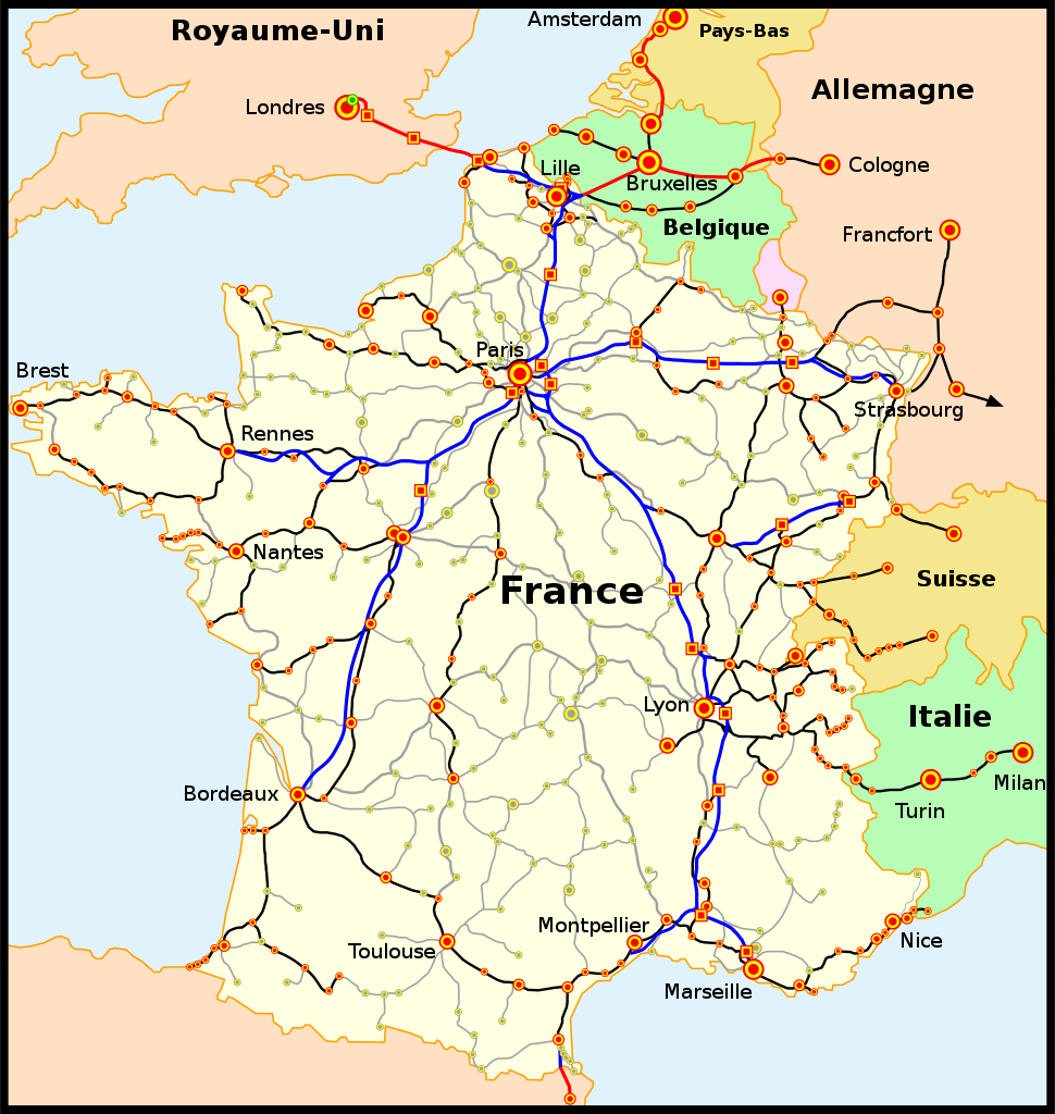
Français : La carte du réseau voyageurs de la SNCF, les TGV internationaux inclus |
| Date | (UTC) |
| Source |
This file was derived from: Carte TGV.svg:  |
| Author |
|
| This is a retouched picture, which means that it has been digitally altered from its original version. Modifications: Noms en français uniquement, ajout de grandes villes. The original can be viewed here: Carte TGV.svg:
|
Licensing[edit]
I, the copyright holder of this work, hereby publish it under the following licenses:
| This file is licensed under the Creative Commons Attribution-Share Alike 3.0 Unported license. | ||
| ||
| This licensing tag was added to this file as part of the GFDL licensing update. |

|
Permission is granted to copy, distribute and/or modify this document under the terms of the GNU Free Documentation License, Version 1.2 or any later version published by the Free Software Foundation; with no Invariant Sections, no Front-Cover Texts, and no Back-Cover Texts. A copy of the license is included in the section entitled GNU Free Documentation License. |
You may select the license of your choice.
Original upload log[edit]
This image is a derivative work of the following images:
- File:Carte_TGV.svg licensed with Cc-by-sa-3.0-migrated, GFDL
- 2011-12-18T11:22:30Z Pic-Sou 1000x1056 (983234 Bytes) update, fix
- 2010-08-03T20:13:07Z Uwe Dedering 1000x1056 (971417 Bytes) layers to separate text from the rest
- 2010-08-03T20:01:46Z Uwe Dedering 1000x1056 (1172824 Bytes) better font
- 2010-01-05T21:33:59Z Madcap 1000x1056 (1172402 Bytes) - (change) colors changed; - (change) font changed to Trebuchet; - (change) Thalys service now on HSL Zuid (Netherland) and LGV 4 (Belgium), classic line not used by the TGV between Antwerp and Schiphol; - (change) The Hague
- 2009-09-03T19:09:08Z Benjism89 1000x1056 (1078415 Bytes) + liège - aix-la-chapelle, bourg - bellegarde
- 2009-08-31T08:39:23Z Benjism89 1000x1056 (1077763 Bytes) + le havre - strasbourg, - lausanne - berne - zurich
- 2009-07-03T14:46:49Z Benjism89 1000x1056 (1082864 Bytes) ajout cherbourg - dijon, paris - les sables d'olonne
- 2008-03-24T22:13:53Z Madcap 1000x1056 (1013443 Bytes) Maybe this time it will work...
- 2008-03-24T00:46:24Z Madcap 1000x1056 (1013443 Bytes) Reverted to version as of 00:40, 24 March 2008
- 2008-03-24T00:45:56Z Madcap 1000x1056 (1013443 Bytes) Old version mistakenly uploaded
- 2008-03-24T00:40:22Z Madcap 1000x1056 (1013443 Bytes) (pl) Liczne poprawki mapki: * Zmiana kolorow * Linia High Speed 1 (Wielka Wrytania): ** drugi odcinek linii otwarty, ** dodano dwa dworce: Stratford International (jescze nie obslugiwany, zaznaczony jako "w budowie") oraz Ebb
- 2007-06-19T07:48:45Z Andrew pmk 1000x1056 (1000219 Bytes) update map to show that LGV Est is now open; correct spelling error
- 2007-06-09T23:11:45Z PemFR 1000x1056 (1028078 Bytes) {{French TGV network map |Description= |Source= |Date= |Author= |Permission= |other_versions= }}
- 2007-06-09T22:37:23Z PemFR 1000x1056 (1028083 Bytes) {{Information |Description=French TGV network map |Source= |Date= |Author= |Permission= |other_versions= }}
- 2006-09-17T12:57:08Z Steff 1000x1056 (1028165 Bytes) == Summary == (en) The map of French railways (SNCF) passengers service, including internationnal TGV high-speed trains. (fr) La carte du réseau voyageurs de la SNCF, les TGV internationaux inclus. (pl) Mapa sieci połącze�
- 2006-03-24T05:53:35Z Madcap 1000x1056 (1058435 Bytes) (en) The map of French railways (SNCF) passengers service, including internationnal TGV high-speed trains. (fr) La carte du réseau voyageurs de la SNCF, les TGV internationaux inclus. (pl) Mapa sieci połączeń pasażerskic
Uploaded with derivativeFX
Licensing[edit]
I, the copyright holder of this work, hereby publish it under the following licenses:
|
|
Permission is granted to copy, distribute and/or modify this document under the terms of the GNU Free Documentation License, Version 1.2 or any later version published by the Free Software Foundation; with no Invariant Sections, no Front-Cover Texts, and no Back-Cover Texts. A copy of the license is included in the section entitled GNU Free Documentation License. |
This file is licensed under the Creative Commons Attribution-Share Alike 3.0 Unported license.
- You are free:
- to share – to copy, distribute and transmit the work
- to remix – to adapt the work
- Under the following conditions:
- attribution – You must give appropriate credit, provide a link to the license, and indicate if changes were made. You may do so in any reasonable manner, but not in any way that suggests the licensor endorses you or your use.
- share alike – If you remix, transform, or build upon the material, you must distribute your contributions under the same or compatible license as the original.
You may select the license of your choice.
File history
Click on a date/time to view the file as it appeared at that time.
| Date/Time | Thumbnail | Dimensions | User | Comment | |
|---|---|---|---|---|---|
| current | 04:49, 13 May 2021 | | 1,000 × 1,056 (999 KB) | Pyrlandczyk (talk | contribs) | updated according to File:Carte_TGV.svg |
| 15:14, 17 April 2016 |  | 1,000 × 1,056 (1,023 KB) | Jack ma (talk | contribs) | correction Angoulême and Poitiers: no new station on the new line | |
| 07:28, 1 January 2016 |  | 1,000 × 1,056 (1 MB) | Jack ma (talk | contribs) | correction Angoulême | |
| 21:30, 1 May 2012 |  | 1,000 × 1,056 (1.05 MB) | PouX (talk | contribs) | == {{int:filedesc}} == {{Information |Description=== Français : La carte du réseau voyageurs de la SNCF, les TGV internationaux inclus |Source={{Derived from|Carte_TGV.svg|display=50}} |Date=2012-05-01 21:27 (UTC) |Author=*File:Carte_TGV.svg: [... |
You cannot overwrite this file.
File usage on Commons
The following 10 pages use this file:
- User:Chumwa/OgreBot/Potential transport maps/2016 April 11-20
- User:Chumwa/OgreBot/Public transport information/2016 April 11-20
- User:Chumwa/OgreBot/Public transport information/2016 January 1-10
- User:Chumwa/OgreBot/Public transport information/2021 May 11-20
- User:Chumwa/OgreBot/Transport Maps/2016 April 11-20
- User:Chumwa/OgreBot/Transport Maps/2016 January 1-10
- User:Chumwa/OgreBot/Transport Maps/2021 May 11-20
- User:Chumwa/OgreBot/Travel and communication maps/2016 April 11-20
- User:Hoff1980/Rail transport in France/2016 April 11-20
- User:Hoff1980/Rail transport in France/2016 January 1-10
File usage on other wikis
The following other wikis use this file:
- Usage on en.wikipedia.org
- Usage on es.wikipedia.org
- Usage on fr.wikipedia.org
- LGV Est européenne
- LGV Rhin-Rhône
- Transport ferroviaire en France
- LGV Atlantique
- Ligne nouvelle Provence Côte d'Azur
- Transversale Alpes Auvergne Atlantique
- Modèle:Palette Lignes à grande vitesse en France
- LGV Sud-Est
- LGV Rhône-Alpes
- LGV Nord
- LGV Méditerranée
- Liaison ferroviaire transalpine Lyon - Turin
- LGV Bretagne-Pays de la Loire
- LGV Bordeaux - Toulouse
- LGV Sud Europe Atlantique
- LGV Interconnexion Est
- Liste des lignes de chemin de fer de France
- Ligne nouvelle Paris - Normandie
- Histoire de la grande vitesse ferroviaire en France
- LGV Paris Orléans Clermont-Ferrand Lyon
- Ligne nouvelle Montpellier - Perpignan
- LGV Bordeaux - Espagne
- LGV Interconnexion Sud
- LGV Paris - Londres par Amiens
- LGV Poitiers - Limoges
- LGV des Titans
- Liaison rapide Normandie - Val de Seine
- Grande vitesse ferroviaire
- Contournement ferroviaire de Nîmes et de Montpellier
- Liste des lignes à grande vitesse en France
- Grande vitesse ferroviaire en France
- Ligne Roissy - Picardie
- Ligne de Perpignan à Figueras
- Virgule de Sablé
- Ligne nouvelle Nice - Italie
- Ligne nouvelle Toulouse - Narbonne
- TP Ferro
- Utilisateur:Ciseleur/Navigation/Transports
- Liaisons nouvelles Ouest Bretagne-Pays de la Loire