File:Catarina 27 mar 2004 1355Z.jpg
Jump to navigation
Jump to search

Size of this preview: 776 × 600 pixels. Other resolutions: 311 × 240 pixels | 621 × 480 pixels | 994 × 768 pixels | 1,280 × 989 pixels | 2,560 × 1,978 pixels | 4,400 × 3,400 pixels.
Original file (4,400 × 3,400 pixels, file size: 2.85 MB, MIME type: image/jpeg)
Captions
Captions
Add a one-line explanation of what this file represents
Summary[edit]
| Description |
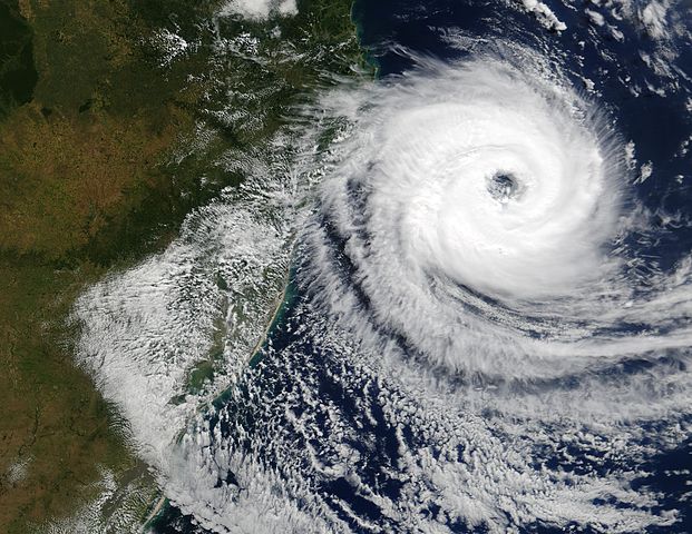
The Moderate Resolution Imaging Spectroradiometer (MODIS) onboard NASA’s Aqua satellite captured this true-color image of a rare tropical cyclone in the South Atlantic ocean just off the coast of Santa Catarina and Rio Grande do Sul, Brazil’s southernmost states on March 27, 2004. The National Hurricane Center in Miami estimated the storm was a full-fledged, Category I hurricane with central winds between 75 mph and 80 mph (121 kph to 129 kph), making it the first hurricane in the South Atlantic in recorded history. Brazilian scientists however, have disagreed, saying the storm had top winds of 50 mph to 56 mph (80 kph to 90 kph), far below the 75 mph (121 kph) threshold of a hurricane. It's interesting to note that the Brazilian Center for Weather Prediction and Climatic Studies does not operate any anemometers (wind measuring devices) in the area or have any Hurricane Hunter aircraft to fly through the storm. All sides were basing their guesses on satellite data only. |
|||||
| Date | ||||||
| Source | http://visibleearth.nasa.gov/view_rec.php?id=6446 | |||||
| Author | Jacques Descloitres, MODIS Rapid Response Team, NASA/GSFC | |||||
| Permission (Reusing this file) |
|

File history
Click on a date/time to view the file as it appeared at that time.
| Date/Time | Thumbnail | Dimensions | User | Comment | |
|---|---|---|---|---|---|
| current | 20:01, 26 November 2006 | | 4,400 × 3,400 (2.85 MB) | Good kitty (talk | contribs) | == Summary == {{Information |Description=The Moderate Resolution Imaging Spectroradiometer (MODIS) onboard NASA’s Aqua satellite captured this true-color image of a rare tropical cyclone in the South Atlantic ocean just off the coast of Santa Catarina a |
You cannot overwrite this file.
File usage on Commons
The following page uses this file:
File usage on other wikis
The following other wikis use this file:
- Usage on he.wikipedia.org
- Usage on pt.wikipedia.org
- Usage on www.wikidata.org