File:Chaudfontaine Liège Belgium Map.png
Jump to navigation
Jump to search
No higher resolution available.
Chaudfontaine_Liège_Belgium_Map.png (290 × 220 pixels, file size: 5 KB, MIME type: image/png)
Captions
Captions
Add a one-line explanation of what this file represents
Summary[edit]
| Description |
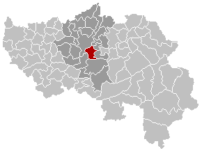
English: Map, municipality belgium Chaudfontaine
Français : Carte indiquant la localisation de la commune de Chaudfontaine dans la Province de Liège.
Nederlands: Gemeentekaart Chaudfontaine |
|||
| Date | 20 February 2004 (first version); 2005-12-24 (last version) | |||
| Source | Transferred from nl.wikipedia to Commons. | |||
| Author |
LennartBolks at Dutch Wikipedia Later versions were uploaded by Westermarck at nl.wikipedia. |
|||
| Other versions |
|


Licensing[edit]
LennartBolks from nl, the copyright holder of this work, hereby publishes it under the following license:

|
Permission is granted to copy, distribute and/or modify this document under the terms of the GNU Free Documentation License, Version 1.2 or any later version published by the Free Software Foundation; with no Invariant Sections, no Front-Cover Texts, and no Back-Cover Texts. A copy of the license is included in the section entitled GNU Free Documentation License. |
| This file is licensed under the Creative Commons Attribution-Share Alike 3.0 Unported license. | ||
| Attribution: LennartBolks | ||
| ||
| This licensing tag was added to this file as part of the GFDL licensing update. |
Original upload log[edit]
The original description page was here. All following user names refer to nl.wikipedia.
- 2005-12-24 22:50 Westermarck 290×220×8 (7547 bytes)
- 2004-02-20 18:46 LennartBolks 290×220×8 (5471 bytes) Gemeentekaart, eigen werk
File history
Click on a date/time to view the file as it appeared at that time.
| Date/Time | Thumbnail | Dimensions | User | Comment | |
|---|---|---|---|---|---|
| current | 18:38, 6 September 2008 | | 290 × 220 (5 KB) | Ludger1961 (talk | contribs) | arrondissement sans Olne et sans Herve |
| 17:47, 6 September 2008 |  | 290 × 220 (5 KB) | Ludger1961 (talk | contribs) | arrondissement sans Olne | |
| 18:31, 11 March 2007 |  | 290 × 220 (7 KB) | Siebrand (talk | contribs) | See desc added after this upload | |
| 20:56, 4 April 2005 |  | 290 × 220 (5 KB) | Nicnac25~commonswiki (talk | contribs) | Map, municipality belgium Chaudfontaine {{PD}} FR; Carte indiquant la localisation de la commune de Chaudfontaine dans la Province de Liège. EN; Map from w:nl:Gebruiker:LennartBolks/kaartenhoekje in Public Domain by the Author choice. [[Category:Ma |
You cannot overwrite this file.
File usage on Commons
The following page uses this file: