File:Chicago-map504.png
Jump to navigation
Jump to search

Size of this preview: 439 × 599 pixels. Other resolutions: 176 × 240 pixels | 352 × 480 pixels | 563 × 768 pixels | 751 × 1,024 pixels | 1,495 × 2,039 pixels.
Original file (1,495 × 2,039 pixels, file size: 210 KB, MIME type: image/png)
Captions
Captions
Add a one-line explanation of what this file represents
Summary[edit]
| Description |
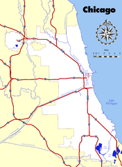
English: Map of Chicago. Content merged from :Image:Chicago-map502b.png and :Image:Chicago-map503-water.png.
I drew this map based on a number of 21st-Century sources including Google Maps, official City of Chicago maps, and USGS data served by TopoZone. It is accurate to about 500 ft. Vector source is available but not in SVG format. John Reid 16:09, 18 May 2006 (UTC) |
| Date | 20 May 2006 (original upload date) |
| Source | Transferred from en.wikipedia to Commons by Ctjf83 using CommonsHelper. |
| Author | John Reid at English Wikipedia |
Licensing[edit]
John Reid at the English-language Wikipedia, the copyright holder of this work, hereby publishes it under the following license:
| This file is licensed under the Creative Commons Attribution-Share Alike 3.0 Unported license. Subject to disclaimers. | ||
| Attribution: John Reid at the English-language Wikipedia | ||
| ||
| This licensing tag was added to this file as part of the GFDL licensing update. |

|
Permission is granted to copy, distribute and/or modify this document under the terms of the GNU Free Documentation License, Version 1.2 or any later version published by the Free Software Foundation; with no Invariant Sections, no Front-Cover Texts, and no Back-Cover Texts. A copy of the license is included in the section entitled GNU Free Documentation License. Subject to disclaimers. |

|
This file was moved to Wikimedia Commons from en.wikipedia using a bot script. All source information is still present. It requires review. Additionally, there may be errors in any or all of the information fields; information on this file should not be considered reliable and the file should not be used until it has been reviewed and any needed corrections have been made. Once the review has been completed, this template should be removed. For details about this file, see below. Check now! |
Original upload log[edit]
The original description page was here. All following user names refer to en.wikipedia.
- 2006-05-20 12:17 John Reid 1570×2114× (551159 bytes) Map of [[Chicago, Illinois]]. Content merged from [[Image:Chicago-map502b.png]] and [[Image:Chicago-map503-water.png]]. == {{int:license}} == I drew this map based on a number of 21st-Century sources including [[Google Maps]], official [[City o
File history
Click on a date/time to view the file as it appeared at that time.
| Date/Time | Thumbnail | Dimensions | User | Comment | |
|---|---|---|---|---|---|
| current | 23:18, 19 April 2012 | | 1,495 × 2,039 (210 KB) | Ras67 (talk | contribs) | cropped, optimized |
| 20:03, 25 August 2010 |  | 1,570 × 2,114 (538 KB) | File Upload Bot (Magnus Manske) (talk | contribs) | {{BotMoveToCommons|en.wikipedia|year={{subst:CURRENTYEAR}}|month={{subst:CURRENTMONTHNAME}}|day={{subst:CURRENTDAY}}}} {{Information |Description={{en|Map of en:Chicago. Content merged from en::Image:Chicago-map502b.png and [[:en::Image:Chica |
You cannot overwrite this file.
File usage on Commons
The following 12 pages use this file:
- File:Chicago Wikivoyage locator maps - Bridgeport-Chinatown.png
- File:Chicago Wikivoyage locator maps - Far West Side.png
- File:Chicago Wikivoyage locator maps - Hyde Park.png
- File:Chicago Wikivoyage locator maps - Lakeview-North Center.png
- File:Chicago Wikivoyage locator maps - Lincoln Park-Old Town.png
- File:Chicago Wikivoyage locator maps - Near West Side.png
- File:Chicago Wikivoyage locator maps - Rogers Park.png
- File:Chicago Wikivoyage locator maps - The Loop.png
- File:Chicago Wikivoyage locator maps - The Near North.png
- File:Chicago Wikivoyage locator maps - The Near South.png
- File:Chicago Wikivoyage locator maps - Uptown.png
- File:Chicago Wikivoyage locator maps - Wicker Park.png
File usage on other wikis
The following other wikis use this file:
- Usage on en.wikipedia.org