File:China Tibet.svg
Jump to navigation
Jump to search

Size of this PNG preview of this SVG file: 705 × 599 pixels. Other resolutions: 282 × 240 pixels | 565 × 480 pixels | 904 × 768 pixels | 1,205 × 1,024 pixels | 2,409 × 2,048 pixels | 1,000 × 850 pixels.
Original file (SVG file, nominally 1,000 × 850 pixels, file size: 135 KB)
Captions
Captions
Add a one-line explanation of what this file represents
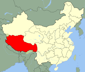
| Description |
An SVG map of China with the Tibet autonomous region highlighted Legend: |
||
| Date | |||
| Source |
self-made; based on CIA public domain maps: |
||
| Author | Joowwww | ||
| Permission (Reusing this file) |
|
||
| Other versions |
|
File history
Click on a date/time to view the file as it appeared at that time.
| Date/Time | Thumbnail | Dimensions | User | Comment | |
|---|---|---|---|---|---|
| current | 14:01, 30 March 2019 | | 1,000 × 850 (135 KB) | Newfraferz87 (talk | contribs) | Need to move the shape to an upper layer … I rest my case :( |
| 16:32, 13 August 2008 |  | 1,000 × 850 (214 KB) | Joowwww (talk | contribs) | added missing laos/vietnam border | |
| 11:24, 14 May 2008 |  | 1,000 × 850 (212 KB) | Joowwww (talk | contribs) | {{Information |Description=An SVG map of China with the Tibet autonomous region highlighted Legend:<br />Image:China map legend.png |Source=self-made; based on CIA public domain maps: *http://www.lib.utexas.edu/maps/middle_east_and_asia/china_admin_9 |
You cannot overwrite this file.
File usage on Commons
The following 4 pages use this file:
File usage on other wikis
The following other wikis use this file:
- Usage on am.wikipedia.org
- Usage on ar.wikipedia.org
- Usage on arz.wikipedia.org
- Usage on br.wikipedia.org
- Usage on bs.wikipedia.org
- Usage on cdo.wikipedia.org
- Usage on cs.wikipedia.org
- Usage on en.wikipedia.org
- Usage on eo.wikipedia.org
- Usage on es.wikipedia.org
- Usage on es.wikinews.org
- Usage on eu.wikipedia.org
- Usage on fr.wikipedia.org
- Usage on fr.wikivoyage.org
- Usage on hr.wikipedia.org
- Usage on incubator.wikimedia.org
- Usage on it.wikipedia.org
- Usage on ja.wikipedia.org
- Usage on ko.wikipedia.org
View more global usage of this file.