File:Chydaeus salvazae - ZooKeys-171-039-g012.jpg
Jump to navigation
Jump to search

Size of this preview: 444 × 599 pixels. Other resolutions: 178 × 240 pixels | 356 × 480 pixels | 569 × 768 pixels | 759 × 1,024 pixels | 1,512 × 2,039 pixels.
Original file (1,512 × 2,039 pixels, file size: 2.11 MB, MIME type: image/jpeg)
Captions
Captions
Add a one-line explanation of what this file represents
| Description |
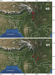
English: Toporelief map of southeastern Asia, illustrating localities for Chydaeus species 60 Chydaeus andrewsi Schauberger: Chydaeus andrewsi andrewsi Schauberger = red dots and Chydaeus andrewsi kumei Ito = green squares 61 Chydaeus salvazae Schauberger = red dots. Only new records reported here are shown. Scale bar = 300 km (in 100 km increments). |
|||
| Date | ||||
| Source | Kataev B, Liang H, Kavanaugh D (2012) Contribution to knowledge of the genus Chydaeus in Xizang Autonomous Region (Tibet) and Yunnan Province, China (Coleoptera, Carabidae, Harpalini). ZooKeys 171: 39-92. doi: 10.3897/zookeys.171.2306 | |||
| Author | Kataev B, Liang H, Kavanaugh D | |||
| Permission (Reusing this file) |
|
File history
Click on a date/time to view the file as it appeared at that time.
| Date/Time | Thumbnail | Dimensions | User | Comment | |
|---|---|---|---|---|---|
| current | 03:24, 26 July 2012 | | 1,512 × 2,039 (2.11 MB) | JarektUploadBot (talk | contribs) | {{subst:User:JarektUploadBot/Open Access Subst |description = Toporelief map of southeastern Asia, illustrating localities for Chydaeus species 60 Chydaeus andrewsi Schauberger: Chydaeus andrewsi andrewsi Schauberger = red dots and Chydaeus andrews... |
You cannot overwrite this file.
File usage on Commons
The following page uses this file:
File usage on other wikis
The following other wikis use this file:
- Usage on ceb.wikipedia.org
- Usage on species.wikimedia.org
- Usage on www.wikidata.org