File:ClumFarmMapUnrestored.jpg
Jump to navigation
Jump to search

Size of this preview: 743 × 600 pixels. Other resolutions: 297 × 240 pixels | 595 × 480 pixels | 951 × 768 pixels | 1,269 × 1,024 pixels | 2,537 × 2,048 pixels | 7,432 × 6,000 pixels.
Original file (7,432 × 6,000 pixels, file size: 29.59 MB, MIME type: image/jpeg)
Captions
Captions
Add a one-line explanation of what this file represents
Summary[edit]
| Description |
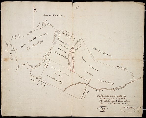
English: Map of a c. 1790 land survey of Clums Corners, in the town of Brunswick, New York, United States. Printed in 1811. (Coordinate location detailed below is approximate.) |
| Date | |
| Source | Scan courtesy the New York State Library |
| Author | McManus, William (1811). Rensselaerwyck Land Surveys: Elizabethtown Book "A" (Brunswick and part of Troy). Box 1, folder 1, page 34. |
| Other versions |
|

| Object location | | View this and other nearby images on: OpenStreetMap |
|---|
Licensing[edit]
This image is in the public domain because it is a mere mechanical scan or photocopy of a public domain original, or – from the available evidence – is so similar to such a scan or photocopy that no copyright protection can be expected to arise. The original itself is in the public domain for the following reason:
This tag is designed for use where there may be a need to assert that any enhancements (eg brightness, contrast, colour-matching, sharpening) are in themselves insufficiently creative to generate a new copyright. It can be used where it is unknown whether any enhancements have been made, as well as when the enhancements are clear but insufficient. For known raw unenhanced scans you can use an appropriate {{PD-old}} tag instead. For usage, see Commons:When to use the PD-scan tag.  |
File history
Click on a date/time to view the file as it appeared at that time.
| Date/Time | Thumbnail | Dimensions | User | Comment | |
|---|---|---|---|---|---|
| current | 19:38, 15 March 2010 | | 7,432 × 6,000 (29.59 MB) | MattWade (talk | contribs) | {{Information |Description={{en|1=Map}} |Source={{own}} |Author=UpstateNYer |Date=1811 |Permission= |other_versions= }} |
You cannot overwrite this file.
File usage on Commons
The following page uses this file: