File:Columbia River - Bridgeport, Washington aerial 01A.jpg
Jump to navigation
Jump to search

Size of this preview: 800 × 531 pixels. Other resolutions: 320 × 213 pixels | 640 × 425 pixels | 1,024 × 680 pixels | 1,280 × 850 pixels | 2,560 × 1,700 pixels | 4,288 × 2,848 pixels.
Original file (4,288 × 2,848 pixels, file size: 8.93 MB, MIME type: image/jpeg)
Captions
Captions
Add a one-line explanation of what this file represents
Summary[edit]
| Object location | | View this and other nearby images on: OpenStreetMap |
|---|
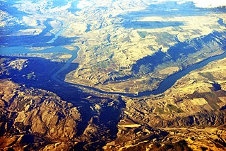
| Description |
English: Aerial view of the Columbia River and Bridgeport, Washington, USA. |
||
| Date | Taken on 1 April 2012 | ||
| Source | Photo by Joe Mabel | ||
| Author | Joe Mabel | ||
| Other versions |
|

Licensing[edit]
Joe Mabel, the copyright holder of this work, hereby publishes it under the following licenses:

|
Permission is granted to copy, distribute and/or modify this document under the terms of the GNU Free Documentation License, Version 1.2 or any later version published by the Free Software Foundation; with no Invariant Sections, no Front-Cover Texts, and no Back-Cover Texts. A copy of the license is included in the section entitled GNU Free Documentation License. |
This file is licensed under the Creative Commons Attribution-Share Alike 3.0 Unported license.
Attribution: Joe Mabel
- You are free:
- to share – to copy, distribute and transmit the work
- to remix – to adapt the work
- Under the following conditions:
- attribution – You must give appropriate credit, provide a link to the license, and indicate if changes were made. You may do so in any reasonable manner, but not in any way that suggests the licensor endorses you or your use.
- share alike – If you remix, transform, or build upon the material, you must distribute your contributions under the same or compatible license as the original.
You may select the license of your choice.
| Annotations | This image is annotated: View the annotations at Commons |
File history
Click on a date/time to view the file as it appeared at that time.
| Date/Time | Thumbnail | Dimensions | User | Comment | |
|---|---|---|---|---|---|
| current | 14:59, 5 April 2012 | | 4,288 × 2,848 (8.93 MB) | Jmabel (talk | contribs) | == {{int:filedesc}} == {{Object location dec|48.01|-119.648}} {{Information |Description={{en|Aerial view of the Columbia River and Bridgeport, Washington, USA.}} |Source=Photo by Joe Mabel |Date={{date|2012-04-01}} |Author=[[User:Jmab... |
You cannot overwrite this file.
File usage on Commons
The following page uses this file:
File usage on other wikis
The following other wikis use this file:
- Usage on de.wikipedia.org
- Usage on en.wikipedia.org
- Usage on fr.wikipedia.org
- Usage on sr.wikipedia.org