File:ConfederaciónPerú-Boliviana div.png
From Wikimedia Commons, the free media repository
Jump to navigation
Jump to search
ConfederaciónPerú-Boliviana_div.png (400 × 500 pixels, file size: 11 KB, MIME type: image/png)
File information
Structured data
Captions
Captions
Add a one-line explanation of what this file represents
Summary[edit]
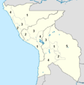
Runa Simi: Piruw-Bulibiyata saywitu (1836-1839).
Español: Mapa de la confederación Perú-Boliviana (1836-1839).
| Estado Nor Peruano | Estado Sur Peruano | Estado boliviano |
|---|---|---|
|
|
|
English: Map of the Peru-Bolivian Confederacy (1836-1839).
Source[edit]
English: Made and uploaded by Huhsunqu.
Español: Hecho y subido por Huhsunqu.
Français : Réalisé et mis en ligne par Huhsunqu.
Italiano: File fatto e caricato da Huhsunqu.
Português: Feito e carregado por Huhsunqu.
Runa Simi: Kaytaqa Huhsunqupam tiksisqan yapasqanpas.
Runa Simi: Kaytaqa Huhsunqupam tiksishqan yapashqanpis.
Licensing[edit]
I, the copyright holder of this work, hereby publish it under the following licenses:

|
Permission is granted to copy, distribute and/or modify this document under the terms of the GNU Free Documentation License, Version 1.2 or any later version published by the Free Software Foundation; with no Invariant Sections, no Front-Cover Texts, and no Back-Cover Texts. A copy of the license is included in the section entitled GNU Free Documentation License.http://www.gnu.org/copyleft/fdl.htmlGFDLGNU Free Documentation Licensetruetrue |
| This file is licensed under the Creative Commons Attribution-Share Alike 3.0 Unported license. | ||
| ||
| This licensing tag was added to this file as part of the GFDL licensing update.http://creativecommons.org/licenses/by-sa/3.0/CC BY-SA 3.0Creative Commons Attribution-Share Alike 3.0truetrue |
You may select the license of your choice.
File history
Click on a date/time to view the file as it appeared at that time.
| Date/Time | Thumbnail | Dimensions | User | Comment | |
|---|---|---|---|---|---|
| current | 20:37, 29 September 2011 |  | 400 × 500 (11 KB) | Edubucher (talk | contribs) | restituyendo mapa de edición vandalica |
| 18:26, 28 September 2011 |  | 368 × 371 (12 KB) | David C. S. (talk | contribs) | Este mapa nuestra el territorio oficial de la Confederación Perú-Boliviana. | |
| 03:34, 28 September 2011 |  | 400 × 500 (11 KB) | Milenioscuro (talk | contribs) | este mapa muestra las reclamaciones peruanas sobre Maynas, si quieres mostrar un mapa sin dicha reclamacion sube otro | |
| 14:45, 9 August 2011 |  | 368 × 371 (12 KB) | David C. S. (talk | contribs) | Ecuador no estuvo en la Confederación | |
| 01:56, 7 March 2011 |  | 400 × 500 (11 KB) | Milenioscuro (talk | contribs) | Reverted to version as of 22:50, 20 May 2010 | |
| 15:12, 25 February 2011 |  | 368 × 371 (11 KB) | David C. S. (talk | contribs) | Territorio | |
| 18:18, 14 February 2011 |  | 368 × 371 (14 KB) | David C. S. (talk | contribs) | {{Information |Description ={{es|1=División territorial de la Confederación Perú-Boliviana}} {{en|1=Territorial division of the Peru-Bolivian Confederation}} {{pt|1=Divisão territorial da Confederação Peruano-Boliviana}} {{pt-br|1=Divisão terr | |
| 18:07, 14 February 2011 |  | 368 × 460 (17 KB) | David C. S. (talk | contribs) | {{Information |Description ={{es|1=División territorial de la Confederación Perú-Boliviana}} |Source =De mi trabajo |Author =David C. S. |Date =2011-02-10 |Permission = |other_versions = }} | |
| 22:50, 20 May 2010 |  | 400 × 500 (11 KB) | Pruxo (talk | contribs) | {{Information |Description=frontera de tarija y antofagasta de acuerdo a la fecha (1937) |Source={{own}} trabajo propio |Author=User:pruxo usuario: pruxo |Date=2010 |Permission= |other_versions= }} frontera de tarija y antofagasta de acuerdo a la fech | |
| 17:31, 26 August 2009 |  | 400 × 500 (14 KB) | Huhsunqu (talk | contribs) | colores aproximados al estándar |
You cannot overwrite this file.
File usage on Commons
There are no pages that use this file.
File usage on other wikis
The following other wikis use this file:
- Usage on fr.wikipedia.org
