File:Cougar Divide 7029.JPG
Jump to navigation
Jump to search

Size of this preview: 800 × 600 pixels. Other resolutions: 320 × 240 pixels | 640 × 480 pixels | 1,024 × 768 pixels | 1,280 × 960 pixels | 1,440 × 1,080 pixels.
Original file (1,440 × 1,080 pixels, file size: 507 KB, MIME type: image/jpeg)
Captions
Captions
Add a one-line explanation of what this file represents
Summary[edit]
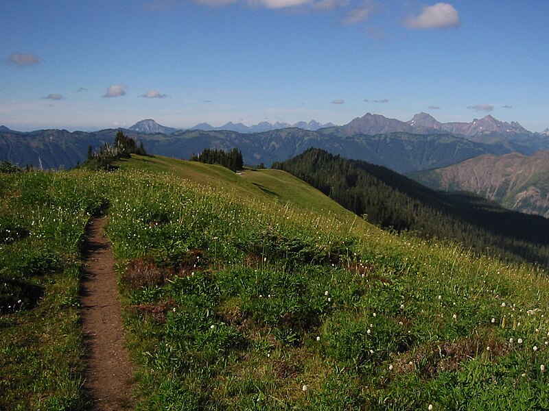
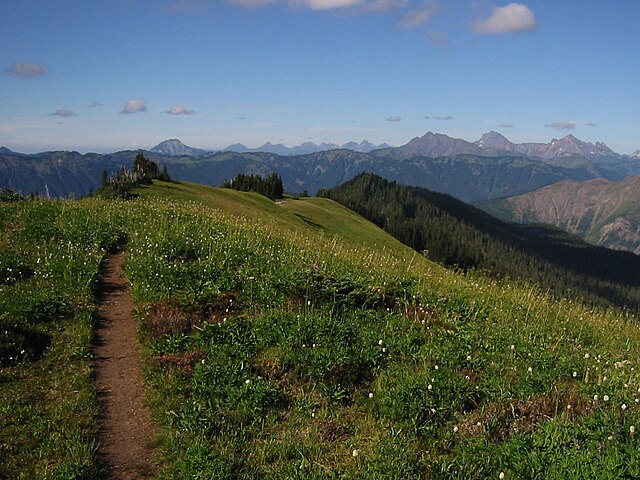
Cougar Divide
| Description |
English: Cougar Divide crest. The three highest summits on the skyline right of center are Tomyhoi Peak (left, 7451 feet), American Border Peak (8026 feet) and Mount Larabee (right, 7868 feet). The highest peak left of center is Mount McGuire (2019 m) in British Columbia. The long ridge in the middle distance is the High Divide. |
| Date | 17 August 2003, 16:47:09 −07:00 |
| Source | Own work |
| Author | Walter Siegmund |
| Camera location | | View this and other nearby images on: OpenStreetMap |
|---|
- Location Datum: WGS84/NAD83
- Viewpoint location: Cougar Divide near Chowder Ridge, Mount Baker Wilderness
- Viewpoint elevation: 5820 foot (1774 m)
- View direction: North-northeast
- Camera: Canon PowerShot S110
- Exposure Time: 1/800
- F Number: f/7.2
- Focal Length: 5.4
- Focal Length In 35mm Film:
- Flash: No
- ISO Speed Rating:
©2006 Walter Siegmund
Licensing[edit]
I, the copyright holder of this work, hereby publish it under the following licenses:

|
Permission is granted to copy, distribute and/or modify this document under the terms of the GNU Free Documentation License, Version 1.2 or any later version published by the Free Software Foundation; with no Invariant Sections, no Front-Cover Texts, and no Back-Cover Texts. A copy of the license is included in the section entitled GNU Free Documentation License. |
| This file is licensed under the Creative Commons Attribution-Share Alike 3.0 Unported license. | ||
| ||
| This licensing tag was added to this file as part of the GFDL licensing update. |
This file is licensed under the Creative Commons Attribution 2.5 Generic license.
- You are free:
- to share – to copy, distribute and transmit the work
- to remix – to adapt the work
- Under the following conditions:
- attribution – You must give appropriate credit, provide a link to the license, and indicate if changes were made. You may do so in any reasonable manner, but not in any way that suggests the licensor endorses you or your use.
You may select the license of your choice.
File history
Click on a date/time to view the file as it appeared at that time.
| Date/Time | Thumbnail | Dimensions | User | Comment | |
|---|---|---|---|---|---|
| current | 13:28, 4 February 2006 | | 1,440 × 1,080 (507 KB) | Wsiegmund (talk | contribs) | Removed image tilt |
| 03:17, 4 February 2006 |  | 1,600 × 1,200 (695 KB) | Wsiegmund (talk | contribs) | '''Cougar Divide''' * '''Description:''' View along the crest of Cougar Divide (foreground). The three highest summits on the skyline right of center are Tomyhoi Peak (left, 7451 feet), American Border Peak (8026 feet) and Mount Larabee (right, 7868 feet) |
You cannot overwrite this file.
File usage on Commons
The following 2 pages use this file: