File:Cover Sheet and Site Plan - Cape Arago Lighthouse, Gregory Point, Charleston, Coos County, OR HABS OR-189 (sheet 1 of 7).png

Original file (14,400 × 9,600 pixels, file size: 5.06 MB, MIME type: image/png)
Captions
Captions
| This image is a JPEG version of the original TIF image at File: Cover Sheet and Site Plan - Cape Arago Lighthouse, Gregory Point, Charleston, Coos County, OR HABS OR-189 (sheet 1 of 7).tif.
However, any edits to the image should be based on the original TIF version in order to prevent generation loss, and both versions should be updated. Do not make edits based on this version. |
Summary[edit]
| Warning | The original file is very high-resolution. It might not load properly or could cause your browser to freeze when opened at full size. |
|---|
| Cover Sheet and Site Plan - Cape Arago Lighthouse, Gregory Point, Charleston, Coos County, OR | ||||
|---|---|---|---|---|
| Photographer |
Haug, Brian, creator |
|||
| Title |
Cover Sheet and Site Plan - Cape Arago Lighthouse, Gregory Point, Charleston, Coos County, OR |
|||
| Depicted place | Oregon; Coos County; Charleston | |||
| Date | 2008 | |||
| Current location |
Library of Congress Prints and Photographs Division Washington, D.C. 20540 USA http://hdl.loc.gov/loc.pnp/pp.print |
|||
| Accession number |
HABS OR-189 (sheet 1 of 7) |
|||
| Credit line |
|
|||
| Notes |
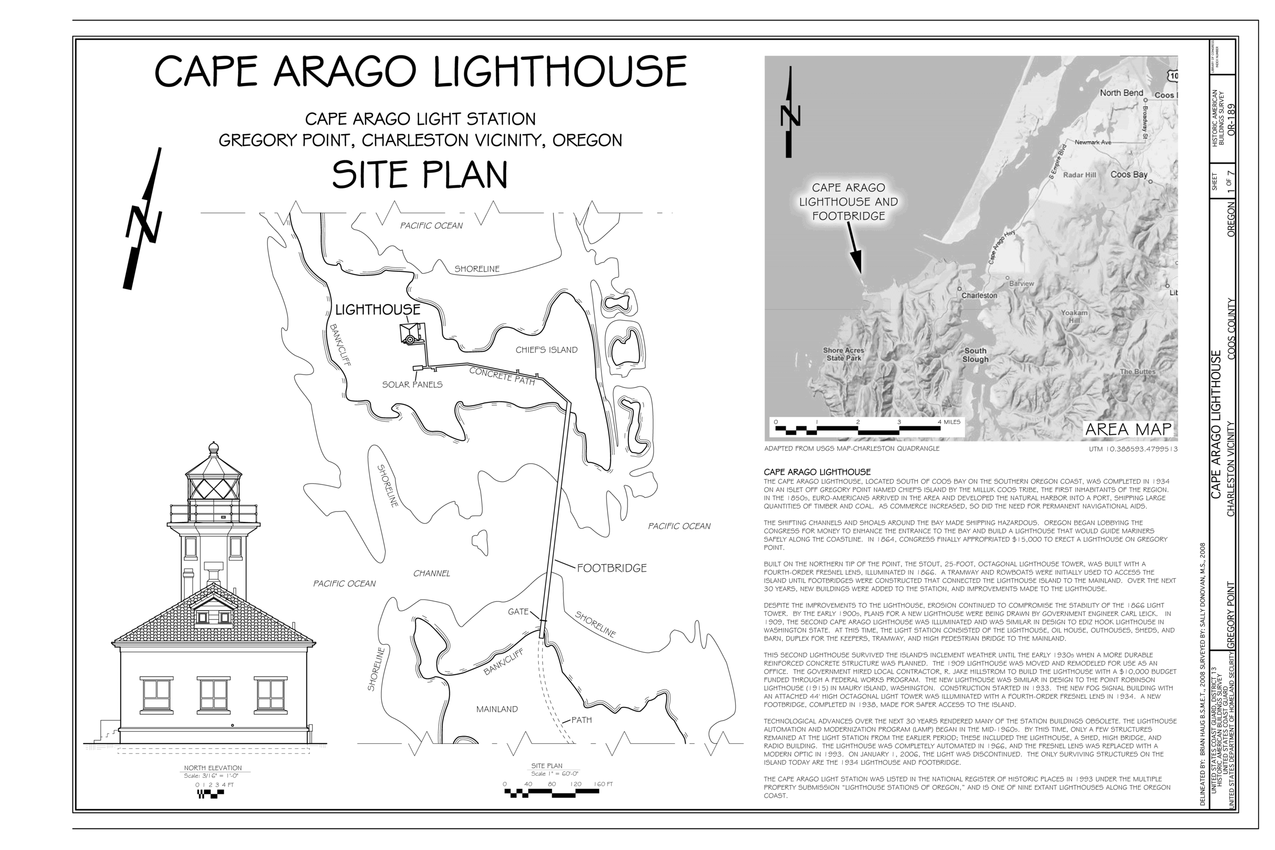
The Cape Arago Lighthouse is also significant architecturally as the only pre-World War II lighthouse constructed of reinforced concrete in the state. The lighthouse represents the introduction of modern building materials and technologies into a traditional form. The tower, illuminated by a fourth-order Fresnel lens, was designed with an attached fog signal building that housed the station’s work, engine, and watch rooms. The lighthouse retains integrity of design, location, setting, materials, workmanship, feeling, and association, and is one of nine extant coastal lighthouses in Oregon. The Cape Arago Lighthouse was listed in the National Register of Historic Places in 1993 under the registration requirements as defined by the multiple property submission “Lighthouse Stations of Oregon” completed in 1991-92. The 1938 footbridge that connects the mainland to the lighthouse island is also listed in the National Register as part of the Cape Arago Light Station. The footbridge is documented in a separate survey, HAER OR-156.
|
|||
| References |
Related names:
|
|||
| Source | https://www.loc.gov/pictures/item/or0576.sheet.00001a | |||
| Permission (Reusing this file) |
|
|||

.png&action=edit§ion=1)
| Object location | | View this and other nearby images on: OpenStreetMap |
|---|
.png¶ms=043.340280_N_-124.328890_E_globe:Earth_class:object_type:object__&language=en)
File history
Click on a date/time to view the file as it appeared at that time.
| Date/Time | Thumbnail | Dimensions | User | Comment | |
|---|---|---|---|---|---|
| current | 16:02, 12 August 2014 | | 14,400 × 9,600 (5.06 MB) | Fæ (talk | contribs) | {{Compressed version|file=File:Cover_Sheet_and_Site_Plan_-_Cape_Arago_Lighthouse,_Gregory_Point,_Charleston,_Coos_County,_OR_HABS_OR-189_(sheet_1_of_7).tif|thumb=nothumb}} =={{int:filedesc}}== {{Photograph | accession number = HABS OR-189 (sheet 1 of... |
You cannot overwrite this file.
File usage on Commons
The following 6 pages use this file:
- File:Cover Sheet and Site Plan - Cape Arago Lighthouse, Gregory Point, Charleston, Coos County, OR HABS OR-189 (sheet 1 of 7).png
- File:Cover Sheet and Site Plan - Cape Arago Lighthouse, Gregory Point, Charleston, Coos County, OR HABS OR-189 (sheet 1 of 7).tif
- File:Isometric Tower Section and Transformer Room Section - Cape Arago Lighthouse, Gregory Point, Charleston, Coos County, OR HABS OR-189 (sheet 6 of 7).png
- File:Isometric Tower Section and Transformer Room Section - Cape Arago Lighthouse, Gregory Point, Charleston, Coos County, OR HABS OR-189 (sheet 6 of 7).tif
- File:Main Floor and Foundation Plan and Ceiling and Roof Framing - Cape Arago Lighthouse, Gregory Point, Charleston, Coos County, OR HABS OR-189 (sheet 2 of 7).tif
- File:North and West Elevation and Dormer Elevation - Cape Arago Lighthouse, Gregory Point, Charleston, Coos County, OR HABS OR-189 (sheet 4 of 7).tif
.png)
.png)
.png&oldid=664329896)