File:DEMChartreuse.png
Jump to navigation
Jump to search

Size of this preview: 664 × 599 pixels. Other resolutions: 266 × 240 pixels | 532 × 480 pixels | 851 × 768 pixels | 1,135 × 1,024 pixels | 2,042 × 1,843 pixels.
Original file (2,042 × 1,843 pixels, file size: 1.08 MB, MIME type: image/png)
Captions
Captions
Add a one-line explanation of what this file represents
Summary[edit]
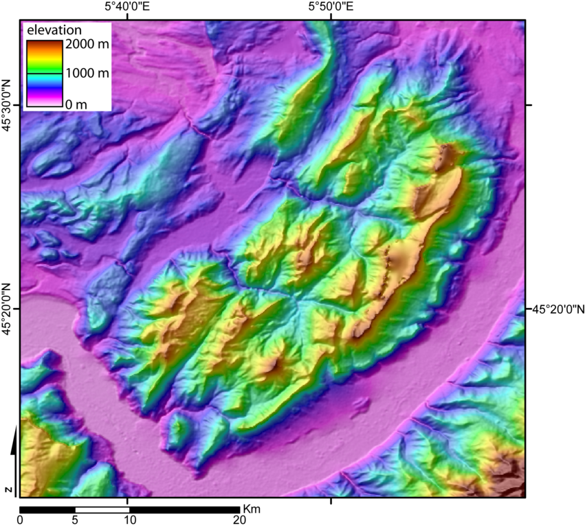
| Description | Digital Elevation Model of the Chartreuse massif (French Alps) created by jide from the 90m pixel size SRTM dataset. The broad valley to the SW and SE is the Isere valley ("Gresivaudan").The mountains to the SE is the Belledonne massif, and to the SW the Vercors massif. The city of Grenoble lies in the Gresivaudan, at the very south of the Chartreuse massif. |
| Date | 8 November 2005 (original upload date) |
| Source | No machine-readable source provided. Own work assumed (based on copyright claims). |
| Author | No machine-readable author provided. Jide~commonswiki assumed (based on copyright claims). |
Licensing[edit]
I, the copyright holder of this work, hereby publish it under the following licenses:

|
Permission is granted to copy, distribute and/or modify this document under the terms of the GNU Free Documentation License, Version 1.2 or any later version published by the Free Software Foundation; with no Invariant Sections, no Front-Cover Texts, and no Back-Cover Texts. A copy of the license is included in the section entitled GNU Free Documentation License. |
| This file is licensed under the Creative Commons Attribution-Share Alike 3.0 Unported license. | ||
| ||
| This licensing tag was added to this file as part of the GFDL licensing update. |
This file is licensed under the Creative Commons Attribution-Share Alike 2.5 Generic, 2.0 Generic and 1.0 Generic license.
- You are free:
- to share – to copy, distribute and transmit the work
- to remix – to adapt the work
- Under the following conditions:
- attribution – You must give appropriate credit, provide a link to the license, and indicate if changes were made. You may do so in any reasonable manner, but not in any way that suggests the licensor endorses you or your use.
- share alike – If you remix, transform, or build upon the material, you must distribute your contributions under the same or compatible license as the original.
You may select the license of your choice.
derivative works[edit]
Derivative works of this file: Plateau Grand-Ratz localisation.svg
File history
Click on a date/time to view the file as it appeared at that time.
| Date/Time | Thumbnail | Dimensions | User | Comment | |
|---|---|---|---|---|---|
| current | 00:39, 8 November 2005 | | 2,042 × 1,843 (1.08 MB) | Jide~commonswiki (talk | contribs) | Digital Elevation Model of the Chartreuse massif (French Alps) created by jide from the 90m pixel size SRTM dataset. The broad valley to the SW and SE is the Isere valley ("Gresivaudan").The mountains to the SE is the Belledonne massif, and to the SW the |
You cannot overwrite this file.
File usage on Commons
The following page uses this file:
File usage on other wikis
The following other wikis use this file:
- Usage on arz.wikipedia.org
- Usage on ceb.wikipedia.org
- Usage on fr.wikipedia.org
- Usage on fr.wikivoyage.org
- Usage on www.wikidata.org