File:DETAIL OF STONEWORK AT SW CORNER. - Philadelphia and Reading Railroad, Mill Creek Bridge, Spanning Mill Creek, east of Schuylkill Expressway (I-76), Gladwyne, Montgomery County, HAER PA,46-GLAWY.V,1-9.tif
Jump to navigation
Jump to search

Size of this JPG preview of this TIF file: 483 × 600 pixels. Other resolutions: 193 × 240 pixels | 387 × 480 pixels | 619 × 768 pixels | 825 × 1,024 pixels | 1,650 × 2,048 pixels | 4,028 × 5,000 pixels.
Original file (4,028 × 5,000 pixels, file size: 19.21 MB, MIME type: image/tiff)
Captions
Captions
Add a one-line explanation of what this file represents
Summary[edit]
| DETAIL OF STONEWORK AT SW CORNER. - Philadelphia and Reading Railroad, Mill Creek Bridge, Spanning Mill Creek, east of Schuylkill Expressway (I-76), Gladwyne, Montgomery County, PA | ||||
|---|---|---|---|---|
| Photographer |
Related names:
|
|||
| Title |
DETAIL OF STONEWORK AT SW CORNER. - Philadelphia and Reading Railroad, Mill Creek Bridge, Spanning Mill Creek, east of Schuylkill Expressway (I-76), Gladwyne, Montgomery County, PA |
|||
| Description |
Nicolls, Gustavus A; Steele, J Dutton; Philadelphia and Reading Railroad; Consolidated Rail Corporation (Conrail); Norfolk Southern Railroad; DeLony, Eric N, project manager; Pennsylvania Historical and Museum Commission, sponsor; Consolidated Rail Corporation (Conrail), sponsor; Spivey, Justin M, historian; Elliott, Joseph E, B, photographer |
|||
| Depicted place | Pennsylvania; Montgomery County; Gladwyne | |||
| Date | Documentation compiled after 1968 | |||
| Dimensions | 4 x 5 in. | |||
| Current location |
Library of Congress Prints and Photographs Division Washington, D.C. 20540 USA http://hdl.loc.gov/loc.pnp/pp.print |
|||
| Accession number |
HAER PA,46-GLAWY.V,1-9 |
|||
| Credit line |
|
|||
| Notes |
|
|||
| Source | https://www.loc.gov/pictures/item/pa3746.photos.362098p | |||
| Permission (Reusing this file) |
|
|||

| Object location | | View this and other nearby images on: OpenStreetMap |
|---|
File history
Click on a date/time to view the file as it appeared at that time.
| Date/Time | Thumbnail | Dimensions | User | Comment | |
|---|---|---|---|---|---|
| current | 05:45, 1 August 2014 | 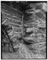 | 4,028 × 5,000 (19.21 MB) | Fæ (talk | contribs) | GWToolset: Creating mediafile for Fæ. HABS 31 July 2014 (3000:3200) |
You cannot overwrite this file.
File usage on Commons
The following page uses this file: