File:DETAIL STUDY- THREE DIFFERENT TYPES OF WINDOW TRIM, RAKING BRICK CORNICE AND SECOND FLOOR STRINGCOURSE. (Located at northwest corner of house) - Mulberry, Cooper River, West HABS SC,8-MONCO.V,5-12.tif
Jump to navigation
Jump to search

Size of this JPG preview of this TIF file: 481 × 600 pixels. Other resolutions: 192 × 240 pixels | 385 × 480 pixels | 616 × 768 pixels | 821 × 1,024 pixels | 1,642 × 2,048 pixels | 4,010 × 5,000 pixels.
Original file (4,010 × 5,000 pixels, file size: 19.12 MB, MIME type: image/tiff)
Captions
Captions
Add a one-line explanation of what this file represents
Summary[edit]
| DETAIL STUDY- THREE DIFFERENT TYPES OF WINDOW TRIM, RAKING BRICK CORNICE AND SECOND FLOOR STRINGCOURSE. (Located at northwest corner of house) - Mulberry, Cooper River, West Branch, Moncks Corner, Berkeley County, SC | ||||
|---|---|---|---|---|
| Title |
DETAIL STUDY- THREE DIFFERENT TYPES OF WINDOW TRIM, RAKING BRICK CORNICE AND SECOND FLOOR STRINGCOURSE. (Located at northwest corner of house) - Mulberry, Cooper River, West Branch, Moncks Corner, Berkeley County, SC |
|||
| Depicted place | South Carolina; Berkeley County; Moncks Corner | |||
| Date | Documentation compiled after 1933 | |||
| Dimensions | 4 x 5 in. | |||
| Current location |
Library of Congress Prints and Photographs Division Washington, D.C. 20540 USA http://hdl.loc.gov/loc.pnp/pp.print |
|||
| Accession number |
HABS SC,8-MONCO.V,5-12 |
|||
| Credit line |
|
|||
| Notes |
|
|||
| References |
|
|||
| Source | https://www.loc.gov/pictures/item/sc0263.photos.152142p | |||
| Permission (Reusing this file) |
|
|||

| Object location | | View this and other nearby images on: OpenStreetMap |
|---|
File history
Click on a date/time to view the file as it appeared at that time.
| Date/Time | Thumbnail | Dimensions | User | Comment | |
|---|---|---|---|---|---|
| current | 08:30, 31 July 2014 | 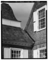 | 4,010 × 5,000 (19.12 MB) | Fæ (talk | contribs) | GWToolset: Creating mediafile for Fæ. HABS 31 July 2014 (3201:3400) |
You cannot overwrite this file.
File usage on Commons
The following page uses this file: