File:Karte des Deutschen Reiches, Weimarer Republik-Drittes Reich 1919–1937.svg
(Redirected from File:DR1919-1937.svg)

Size of this PNG preview of this SVG file: 660 × 600 pixels. Other resolutions: 264 × 240 pixels | 528 × 480 pixels | 845 × 768 pixels | 1,127 × 1,024 pixels | 2,254 × 2,048 pixels | 974 × 885 pixels.
Original file (SVG file, nominally 974 × 885 pixels, file size: 1.7 MB)
Captions
Captions
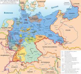
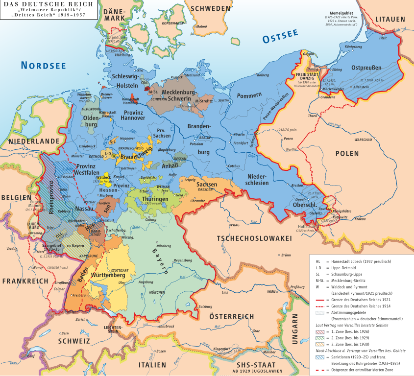
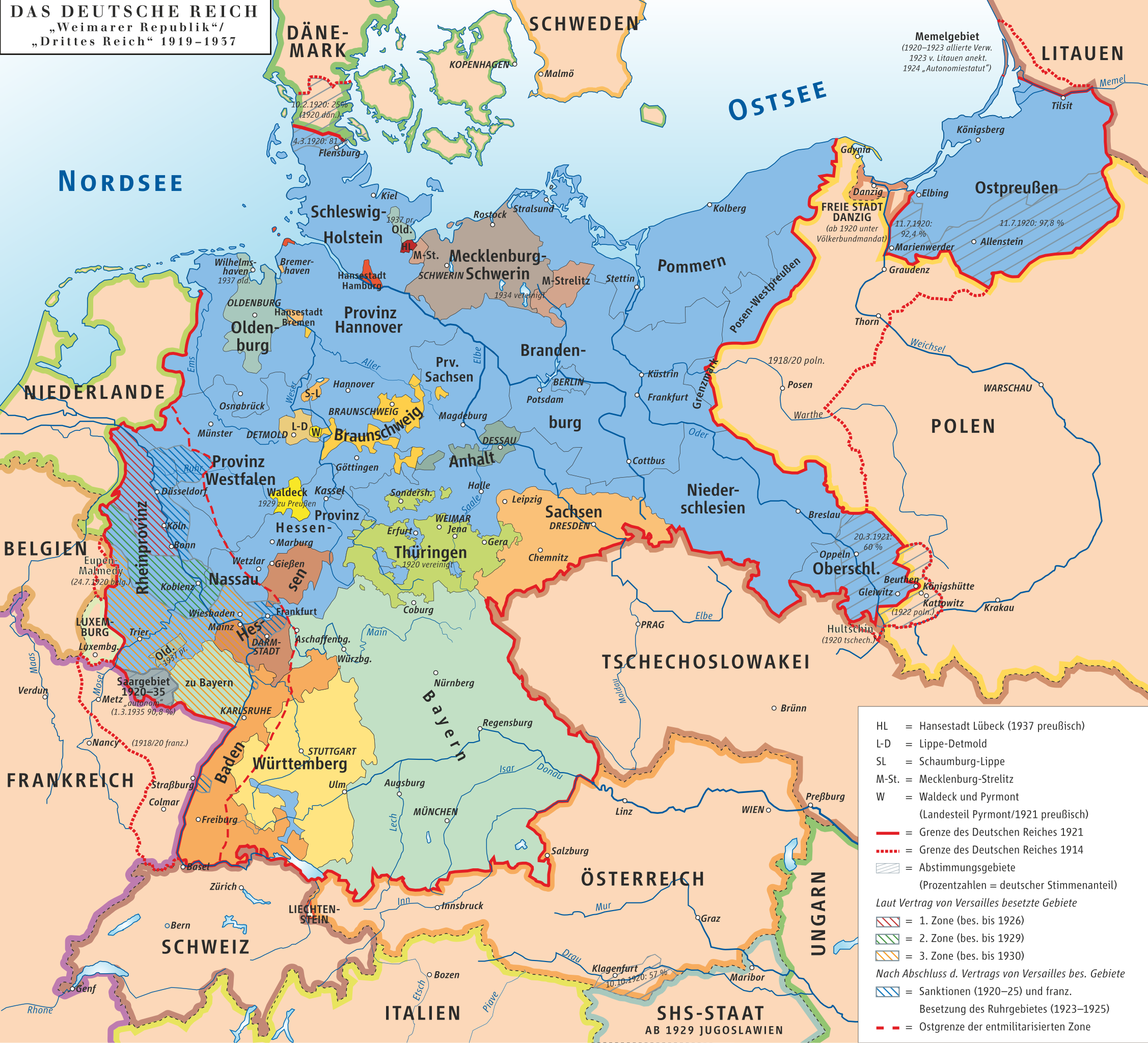
Map of German Reich 1919-1937
Summary[edit]
| Description |
Deutsch: Karte des Deutschen Reiches, »Weimarer Republik/Drittes Reich« 1919–1937 English: Map of the German Reich, (Republic of Weimar/Third Reich) 1919–1937 |
| Date | |
| Source | own drawing/Source of Information: Putzger – Historischer Weltatlas, 89. Auflage, 1965 |
| Author | kgberger |
| Permission (Reusing this file) |
GNU FDL |
| SVG development |
Licensing[edit]
I, the copyright holder of this work, hereby publish it under the following licenses:

|
Permission is granted to copy, distribute and/or modify this document under the terms of the GNU Free Documentation License, Version 1.2 or any later version published by the Free Software Foundation; with no Invariant Sections, no Front-Cover Texts, and no Back-Cover Texts. A copy of the license is included in the section entitled GNU Free Documentation License. |
| This file is licensed under the Creative Commons Attribution-Share Alike 3.0 Unported license. | ||
| ||
| This licensing tag was added to this file as part of the GFDL licensing update. |
This file is licensed under the Creative Commons Attribution 2.5 Generic license.
- You are free:
- to share – to copy, distribute and transmit the work
- to remix – to adapt the work
- Under the following conditions:
- attribution – You must give appropriate credit, provide a link to the license, and indicate if changes were made. You may do so in any reasonable manner, but not in any way that suggests the licensor endorses you or your use.
You may select the license of your choice.
File history
Click on a date/time to view the file as it appeared at that time.
| Date/Time | Thumbnail | Dimensions | User | Comment | |
|---|---|---|---|---|---|
| current | 20:17, 21 January 2023 | | 974 × 885 (1.7 MB) | Felicior (talk | contribs) | move Freiburg further to the east |
| 11:22, 13 December 2020 |  | 974 × 885 (1.45 MB) | Intforce (talk | contribs) | Reduce SVG file size | |
| 12:30, 9 January 2013 |  | 974 × 885 (2.06 MB) | Ziegelbrenner (talk | contribs) | 2013-01-09 | |
| 16:34, 27 July 2010 |  | 775 × 775 (1.07 MB) | Beao (talk | contribs) | Tweak. | |
| 16:31, 27 July 2010 |  | 779 × 782 (1.07 MB) | Beao (talk | contribs) | Removed border. | |
| 16:37, 7 November 2008 |  | 782 × 784 (1,002 KB) | Ahellwig (talk | contribs) | test | |
| 16:24, 7 November 2008 | No thumbnail | (1,003 KB) | ChrisiPK (talk | contribs) | Reverted to version as of 12:35, 18 January 2008: new version seems to be broken | |
| 12:37, 18 January 2008 | No thumbnail | (1,003 KB) | Ziegelbrenner (talk | contribs) | == Beschreibung == {{Information |Description=Karte des Deutschen Reiches, »Weimarer Republik/Drittes Reich« 1919–1937 / Map of German Reich, »Republic of Weimar/Third Reich« 1919–1937 |Source=own drawing/Source of Information: Putzger – Histori | |
| 12:35, 18 January 2008 | No thumbnail | (1,003 KB) | Ziegelbrenner (talk | contribs) | == Beschreibung == {{Information |Description=Karte des Deutschen Reiches, »Weimarer Republik/Drittes Reich« 1919–1937 / Map of German Reich, »Republic of Weimar/Third Reich« 1919–1937 |Source=own drawing/Source of Information: Putzger – Histori |
You cannot overwrite this file.
File usage on Commons
The following 10 pages use this file:
- Atlas of Germany
- Weimarer Republik
- User:Cookroach/Briefmarkenalben-Europa
- User:Magog the Ogre/Multilingual legend/2020 December 11-20
- User:Magog the Ogre/Multilingual legend/2023 January 21-31
- File:DR1919-1937.svg (file redirect)
- File:Deutsches Reich2.png
- Category:Maps of the Weimar Republic
- Category:People of the Weimar Republic
- Category:Weimar Republic
File usage on other wikis
The following other wikis use this file:
- Usage on af.wikipedia.org
- Usage on als.wikipedia.org
- Usage on an.wikipedia.org
- Usage on ar.wikipedia.org
- تورينغن
- ولاية بريمن
- بافاريا
- ساكسونيا
- بروسيا
- جمهورية فايمار
- جمهورية عنق الزجاجة
- قالب:ولايات جمهورية فايمار
- ولاية بروسيا الحرة
- بوابة:بافاريا
- بوابة:بافاريا/قوالب
- ولاية أنهالت الحرة
- الرايخ الرابع
- مستخدم:Marksman003/قائمة بشعارات النبالة في ألمانيا
- قائمة الولايات التاريخية الألمانية
- التقسيمات الإدارية في ألمانيا النازية
- جمهورية بافاريا السوفيتية
- ولاية بافاريا الشعبية
- Usage on ast.wikipedia.org
- Usage on azb.wikipedia.org
- Usage on ba.wikipedia.org
- Usage on be-tarask.wikipedia.org
- Usage on be.wikipedia.org
- Usage on bg.wikipedia.org
- Usage on bn.wikipedia.org
- Usage on bs.wikipedia.org
- Usage on ca.wikipedia.org
- Usage on cs.wikipedia.org
- Usage on da.wikipedia.org
- Usage on de.wikipedia.org
View more global usage of this file.