File:D'Oyly Carte Island in 2001 from south (footbridge side) - geograph.org.uk - 128609.jpg
(Redirected from File:Desborough Cut, near Shepperton. - geograph.org.uk - 128609.jpg)
No higher resolution available.
D'Oyly_Carte_Island_in_2001_from_south_(footbridge_side)_-_geograph.org.uk_-_128609.jpg (640 × 435 pixels, file size: 199 KB, MIME type: image/jpeg)
Captions
Captions
Add a one-line explanation of what this file represents
Summary[edit]
_-_geograph.org.uk_-_128609.jpg&action=edit§ion=1)
| Description |
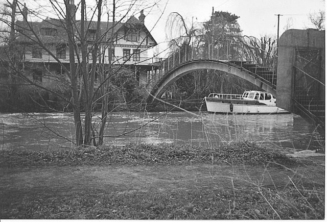
English: Desborough Cut, near Shepperton. The cottage is approached by a private, arched, metal bridge across the Desborough Cut. The cut is a short cut on the Thames for boat traffic, putting the cottage on D'Oyly Carte Island where Sir Arthur Sullivan's house is located. Boats, like this one, are moored for most of the year. |
| Date | |
| Source | From geograph.org.uk |
| Author | Colin Smith |
| Attribution (required by the license) | Colin Smith / Desborough Cut, near Shepperton. / |
| Camera location | | View this and other nearby images on: OpenStreetMap |
|---|
_-_geograph.org.uk_-_128609.jpg¶ms=051.382666_N_-000.454205_E_globe:Earth_type:camera__&language=en)
| Object location | | View this and other nearby images on: OpenStreetMap |
|---|
_-_geograph.org.uk_-_128609.jpg¶ms=051.382620_N_-000.454400_E_globe:Earth_class:object_type:object_source:geograph-osgb36(TQ07656597)_heading:45.00&language=en)
Licensing[edit]
_-_geograph.org.uk_-_128609.jpg&action=edit§ion=2)

|
This image was taken from the Geograph project collection. See this photograph's page on the Geograph website for the photographer's contact details. The copyright on this image is owned by Colin Smith and is licensed for reuse under the Creative Commons Attribution-ShareAlike 2.0 license.
|
This file is licensed under the Creative Commons Attribution-Share Alike 2.0 Generic license.
Attribution: Colin Smith
- You are free:
- to share – to copy, distribute and transmit the work
- to remix – to adapt the work
- Under the following conditions:
- attribution – You must give appropriate credit, provide a link to the license, and indicate if changes were made. You may do so in any reasonable manner, but not in any way that suggests the licensor endorses you or your use.
- share alike – If you remix, transform, or build upon the material, you must distribute your contributions under the same or compatible license as the original.
File history
Click on a date/time to view the file as it appeared at that time.
| Date/Time | Thumbnail | Dimensions | User | Comment | |
|---|---|---|---|---|---|
| current | 20:11, 26 October 2013 | | 640 × 435 (199 KB) | Adam37 (talk | contribs) | {{Information |Description=Eyot House, |Source=https://commons.wikimedia.org/wiki/File:Desborough_Cut,_near_Shepperton._-_geograph.org.uk_-_128609.jpg |Date=26 October 2013 |source=From [http://www.geograph.org.uk/photo/128609 geograph.org.uk] |author... |
| 19:59, 26 October 2013 |  | 640 × 435 (178 KB) | Adam37 (talk | contribs) | Due to the equipment/rendering the colouring is incorrect, even for a time of extreme flooding in 2001 when this was taken. It is very well shot however. The description is: Eyot House, D'Oyly Carte Island, Weybridge. | |
| 02:49, 31 January 2010 |  | 640 × 435 (139 KB) | GeographBot (talk | contribs) | == {{int:filedesc}} == {{Information |description={{en|1=Desborough Cut, near Shepperton. The cottage is approached by a private, arched, metal bridge across the Desborough Cut. The cut is a short cut on the Thames for boat traffic, putting the cottage on |
You cannot overwrite this file.
File usage on Commons
The following page uses this file:
File usage on other wikis
The following other wikis use this file:
- Usage on de.wikipedia.org
_-_geograph.org.uk_-_128609.jpg&oldid=845662477)