File:Detail view of east approach girder bearings at pier 46 - Macombs Dam Bridge, Spanning Harlem River Between 155th Street Viaduct, Jerome Avenue, and East 162nd Street, Bronx, HAER NY,31-NEYO,175-65.tif
Jump to navigation
Jump to search

Size of this JPG preview of this TIF file: 472 × 599 pixels. Other resolutions: 189 × 240 pixels | 378 × 480 pixels | 605 × 768 pixels | 807 × 1,024 pixels | 1,613 × 2,048 pixels | 3,939 × 5,000 pixels.
Original file (3,939 × 5,000 pixels, file size: 18.79 MB, MIME type: image/tiff)
Captions
Captions
Add a one-line explanation of what this file represents
Summary[edit]
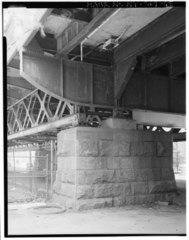
| Detail view of east approach girder bearings at pier 46 - Macombs Dam Bridge, Spanning Harlem River Between 155th Street Viaduct, Jerome Avenue, and East 162nd Street, Bronx, Bronx County, NY | ||||
|---|---|---|---|---|
| Photographer |
Weinstein, Gerald |
|||
| Title |
Detail view of east approach girder bearings at pier 46 - Macombs Dam Bridge, Spanning Harlem River Between 155th Street Viaduct, Jerome Avenue, and East 162nd Street, Bronx, Bronx County, NY |
|||
| Depicted place | New York; Bronx County; Bronx | |||
| Date | 1994 | |||
| Dimensions | 4 x 5 in. | |||
| Current location |
Library of Congress Prints and Photographs Division Washington, D.C. 20540 USA http://hdl.loc.gov/loc.pnp/pp.print |
|||
| Accession number |
HAER NY,31-NEYO,175-65 |
|||
| Credit line |
|
|||
| Notes |
|
|||
| Source | https://www.loc.gov/pictures/item/ny1732.photos.350649p | |||
| Permission (Reusing this file) |
|
|||

| Object location | | View this and other nearby images on: OpenStreetMap |
|---|
File history
Click on a date/time to view the file as it appeared at that time.
| Date/Time | Thumbnail | Dimensions | User | Comment | |
|---|---|---|---|---|---|
| current | 07:54, 1 August 2014 |  | 3,939 × 5,000 (18.79 MB) | Fæ (talk | contribs) | GWToolset: Creating mediafile for Fæ. HABS 31 July 2014 (2301:2600) |
You cannot overwrite this file.
File usage on Commons
The following page uses this file: