File:Divided Yemen ar.svg
Jump to navigation
Jump to search

Size of this PNG preview of this SVG file: 800 × 483 pixels. Other resolutions: 320 × 193 pixels | 640 × 386 pixels | 1,024 × 618 pixels | 1,280 × 772 pixels | 2,560 × 1,544 pixels | 1,210 × 730 pixels.
Original file (SVG file, nominally 1,210 × 730 pixels, file size: 44 KB)
Captions
Captions
Add a one-line explanation of what this file represents

|
This SVG file contains embedded text that can be translated into your language, using any capable SVG editor, text editor or the SVG Translate tool. For more information see: About translating SVG files. |
Summary[edit]
| Description |
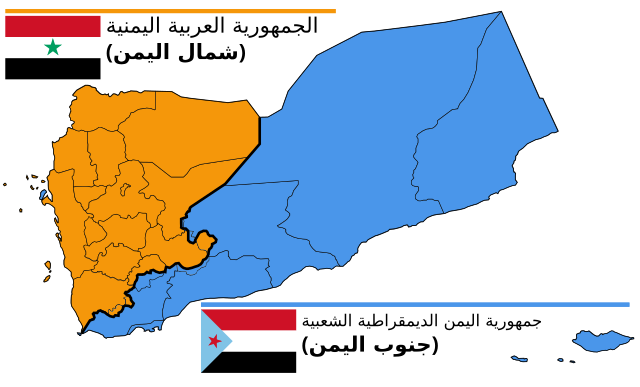
English: Map of North and South Yemen prior to unification.
Français : Le Yémen avant l'unification.
Português: Iêmen do Norte (em laranja) e Iêmen do Sul (em azul) antes de 1990. |
| Date | (UTC) |
| Source | |
| Author |
|
| Other versions |
|


.svg)


Licensing[edit]
I, the copyright holder of this work, hereby publish it under the following license:
This file is licensed under the Creative Commons Attribution-Share Alike 3.0 Unported license.
- You are free:
- to share – to copy, distribute and transmit the work
- to remix – to adapt the work
- Under the following conditions:
- attribution – You must give appropriate credit, provide a link to the license, and indicate if changes were made. You may do so in any reasonable manner, but not in any way that suggests the licensor endorses you or your use.
- share alike – If you remix, transform, or build upon the material, you must distribute your contributions under the same or compatible license as the original.
Original upload log[edit]
This image is a derivative work of the following images:
- File:Divided_Yemen.svg licensed with Cc-by-sa-3.0
- 2011-10-20T21:25:42Z Mnmazur 1210x730 (47916 Bytes) == {{int:filedesc}} == {{Information |Description={{en|1=Map of North and South Yemen prior to unification.}} |Source=*[[:File:Map_of_North_and_South_Yemen.png|]] *[[:File:Flag_of_North_Yemen.svg|]] *[[:File:Flag_of_South_Yem
Uploaded with derivativeFX
File history
Click on a date/time to view the file as it appeared at that time.
| Date/Time | Thumbnail | Dimensions | User | Comment | |
|---|---|---|---|---|---|
| current | 13:53, 9 November 2020 | | 1,210 × 730 (44 KB) | AlMahra67 (talk | contribs) | Corrected Shabwah boundary and included Mukeiras |
| 13:02, 11 June 2016 |  | 1,210 × 730 (49 KB) | Flappiefh (talk | contribs) | Removed Dhale Governorate because it didn't exist at that time (created after 1990 unification). | |
| 19:36, 20 October 2012 |  | 1,210 × 730 (47 KB) | Mnmazur (talk | contribs) | Correction: Perim to PDR Yemen (thanks, Thabet202!) | |
| 21:49, 20 October 2011 |  | 1,210 × 730 (47 KB) | Mnmazur (talk | contribs) | {{Translation possible}} == {{int:filedesc}} == {{Information |Description={{en|1=Map of North and South Yemen prior to unification.}} {{fr|1=Le Yémen avant l'unification.}} {{pt|1=Iêmen do Norte (em laranja) e Iêmen do Sul (em azul) antes de 1990.}} | |
You cannot overwrite this file.
File usage on Commons
The following 11 pages use this file:
File usage on other wikis
The following other wikis use this file:
- Usage on ar.wikipedia.org
- Usage on fr.wikipedia.org