File:Dobroudja-fr.jpg
Jump to navigation
Jump to search

Size of this preview: 358 × 600 pixels. Other resolutions: 143 × 240 pixels | 286 × 480 pixels | 458 × 768 pixels | 611 × 1,024 pixels | 1,479 × 2,478 pixels.
Original file (1,479 × 2,478 pixels, file size: 353 KB, MIME type: image/jpeg)
Captions
Captions
Add a one-line explanation of what this file represents
Summary[edit]
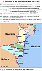
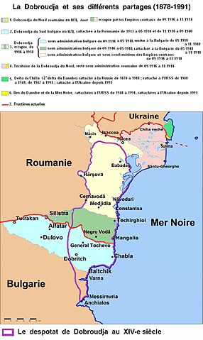
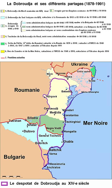
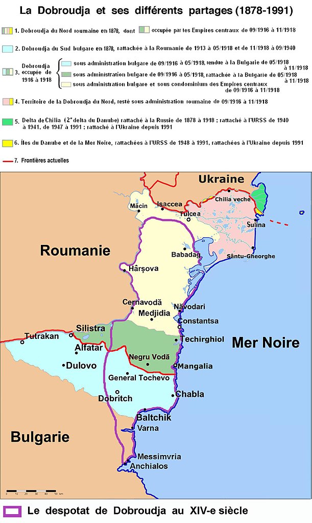
| Description | Carte de la Dobroudja | ||||||||
| Date | |||||||||
| Source | Wikipedia en bulgare : http://bg.wikipedia.org/wiki/Картинка:Dobrudja_Borders_BG.png | ||||||||
| Author | http://bg.wikipedia.org/wiki/Потребител:Пакко/Пламен Цветков, lighty modified according with Pierre Renouvin, La Crise Européenne et la Première Guerre Mondiale, p. 532, Fritz Fischer, Les Buts de Guerre de l'Allemagne impériale, p. 514 and the maps of N.P.Comnène, Roumania through the ages, Payot, Lausanne & Paris, 1919. | ||||||||
| Permission (Reusing this file) |
|

Carte traduite par User:Moumine et mise en page par Gustave Graetzlin
File history
Click on a date/time to view the file as it appeared at that time.
| Date/Time | Thumbnail | Dimensions | User | Comment | |
|---|---|---|---|---|---|
| current | 14:32, 16 June 2017 | | 1,479 × 2,478 (353 KB) | Julieta39 (talk | contribs) | More complete version with the despotate (14th cent.) |
| 11:28, 27 July 2015 |  | 1,479 × 2,048 (304 KB) | Spiridon Ion Cepleanu (talk | contribs) | Cosmetic little changes | |
| 21:59, 14 November 2014 |  | 1,479 × 2,048 (296 KB) | Spiridon Ion Cepleanu (talk | contribs) | Some changes according with Pierre Renouvin, La Crise Européenne et la Première Guerre Mondiale, p. 532, Fritz Fischer, Les Buts de Guerre de l'Allemagne impériale, p. 514 and the maps of N.P.Comnène, Roumania through the ages, Payot, Lausanne et P... | |
| 09:40, 12 July 2008 |  | 1,479 × 2,048 (259 KB) | Spiridon Ion Cepleanu (talk | contribs) | Changing borders in Dobruja Les frontières changeantes en Dobroudja | |
| 16:40, 29 November 2007 |  | 1,479 × 2,048 (271 KB) | Moumine~commonswiki (talk | contribs) | {{Information |Description=Carte de la Dobroudja |Source=Spiridon MANOLIU |Date=29 novembre 2007 |Author=Plamen Tzvetkov |Permission=http://commons.wikimedia.org/w/index.php?title=User_talk%3AMoumine&diff=8697999&oldid=6852645 |o | |
| 20:21, 15 November 2007 |  | 1,479 × 2,048 (274 KB) | Moumine~commonswiki (talk | contribs) | {{Information |Description=Carte de la Dobroudja |Source=Wikipedia en bulgare : http://bg.wikipedia.org/wiki/Картинка:Dobrudja_Borders_BG.png |Date=15 novembre 2007 |Author=http://bg.wikipedia.org/wiki/Потребител:Пакко / Пламе� |
You cannot overwrite this file.
File usage on Commons
There are no pages that use this file.
File usage on other wikis
The following other wikis use this file:
- Usage on fr.wikipedia.org
- Usage on oc.wikipedia.org
- Usage on ro.wikipedia.org