File:Durnkrut und Bosing. NYPL1226505.tiff
Jump to navigation
Jump to search

Size of this JPG preview of this TIF file: 500 × 600 pixels. Other resolutions: 200 × 240 pixels | 400 × 480 pixels | 640 × 768 pixels | 854 × 1,024 pixels | 1,707 × 2,048 pixels | 4,504 × 5,403 pixels.
Original file (4,504 × 5,403 pixels, file size: 69.63 MB, MIME type: image/tiff)
Captions
Captions
Add a one-line explanation of what this file represents
Summary[edit]
| Description | Durnkrut und Bosing.; Spezialkarte der osterreichisch-ungarischen Monarchie. | |||||||||||||||||||||||
| Catalogue call number | Map Div. 04-336 | |||||||||||||||||||||||
| Item/Page/Plate | 12:XVI | |||||||||||||||||||||||
| Date | ||||||||||||||||||||||||
| Source |
http://digitalgallery.nypl.org/nypldigital/dgkeysearchdetail.cfm?imageID=1226505
|
|||||||||||||||||||||||
| Author | Austro-Hungarian Monarchy. Militärgeographisches Institut. -- Cartographer | |||||||||||||||||||||||
| Permission (Reusing this file) |
From The Lionel Pincus and Princess Firyal Map Division. http://maps.nypl.org
|
|||||||||||||||||||||||
| Source description | 776 maps ; 38 x 55 cm. or smaller. | |||||||||||||||||||||||
| Location | Stephen A. Schwarzman Building / The Lionel Pincus and Princess Firyal Map Division | |||||||||||||||||||||||
| Digital item published | 6-23-2005; updated 2-17-2012 | |||||||||||||||||||||||
| Digital ID | 1226505 | |||||||||||||||||||||||

The making of this file was supported by Wikimedia UK.
To see other files made with the support of Wikimedia UK, please see the category Supported by Wikimedia UK.
|
File history
Click on a date/time to view the file as it appeared at that time.
| Date/Time | Thumbnail | Dimensions | User | Comment | |
|---|---|---|---|---|---|
| current | 00:17, 28 April 2014 | 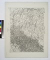 | 4,504 × 5,403 (69.63 MB) | Fæ (talk | contribs) | GWToolset:: Creating mediafile for Fæ. Tranche 3 5495-7474 (2) |
You cannot overwrite this file.
File usage on Commons
There are no pages that use this file.