File:ECEF.svg
Jump to navigation
Jump to search

Size of this PNG preview of this SVG file: 743 × 600 pixels. Other resolutions: 297 × 240 pixels | 595 × 480 pixels | 952 × 768 pixels | 1,269 × 1,024 pixels | 2,537 × 2,048 pixels | 975 × 787 pixels.
Original file (SVG file, nominally 975 × 787 pixels, file size: 47 KB)
Captions
Captions
ECEF model
Summary[edit]
| Description |
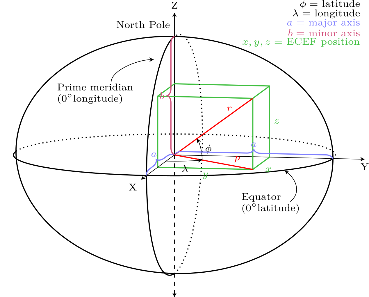
English: Diagram of Earth Centered, Earth Fixed coordinates in relation to latitude and longitude. |
| Date | |
| Source | Own work |
| Author | Krishnavedala |
W3C-validity not checked.
| LaTeX source code |
|---|
\documentclass[10pt,border=1pt,tikz,class=scrartcl]{standalone}
\usepackage[T1]{fontenc}
\usepackage[utf8]{inputenc}
\usepackage{lmodern}
\usepackage{mathtools}
\usepackage{gensymb}

\usepackage{tikz-3dplot}
\usetikzlibrary{arrows,calc,positioning,decorations.pathreplacing}

\begin{document}
\scriptsize
\tdplotsetmaincoords {80}{100}
\begin{tikzpicture}[thick,auto,>=stealth,xscale=4,yscale=3,tdplot_main_coords]
	\pgfmathsetmacro{\pxyz}{.6}
	\draw [->,thin] (0,0,0) -- (1.2,0,0) node [anchor=north east] {X};
	\draw [->,thin] (0,0,0) -- (0,1.2,0) node [anchor=north] {Y};
	\draw [->,thin] (0,0,0) -- (0,0,1.2) node [anchor=south] {Z};
	\tdplotdrawarc {(0,0,0)}{1}{-90}{90}{}{};
	\tdplotdrawarc [dotted] {(0,0,0)}{1}{90}{270}{}{};
	\draw [green!50!gray] (\pxyz,0,0) -- ++(0,\pxyz,0) node [pos=.5,below] {$y$}
		-- ++(-\pxyz,0,0) node [pos=.5,below right] {$x$}
		-- ++(0,0,\pxyz) node [pos=.5,right] {$z$}
		-- ++(0,-\pxyz,0) -- ++(\pxyz,0,0) -- ++(0,0,-\pxyz)
		(\pxyz,0,\pxyz) -- ++(0,\pxyz,0) -- ++(0,0,-\pxyz)
		(\pxyz,\pxyz,\pxyz) -- ++(-\pxyz,0,0)
	;
	\draw [red] (0,0,0) -- (\pxyz,\pxyz,0)	node [pos=.8,above] {$p$}
		(0,0,0) -- (\pxyz,\pxyz,\pxyz)	node [pos=.7,above] {$r$};
	\tdplotdrawarc [->,thin] {(0,0,0)} {.3} {0}{45}{below}{$\lambda$};
	\tdplotgetpolarcoords{\pxyz}{\pxyz}{\pxyz}
	\tdplotsetthetaplanecoords{45};
	\tdplotdrawarc [tdplot_rotated_coords,->,thin] {(0,0,0)} {.3} {90}{\tdplotrestheta}{right}{$\phi$};
	%\draw [->,dashed] (0,0,0) -- (-1.2,0);
	%\draw [->,dashed] (0,0,0) -- (0,-1.2,0);
	\draw [->,dashed,thin] (0,0,0) -- (0,0,-1.2);
	\tdplotsetthetaplanecoords{0};
	\tdplotdrawarc [tdplot_rotated_coords]{(0,0,0)}{1}{0}{180}{}{};
	\tdplotdrawarc [tdplot_rotated_coords,dotted] {(0,0,0)}{1}{180}{360}{}{};
	\tdplotsetthetaplanecoords{90};
	\tdplotdrawarc [tdplot_rotated_coords]{(0,0,0)}{1}{0}{360}{}{};
	\draw (0,0,0) + (0,0,1.1) node [left] {North Pole}
		 (0,0,0) + (.5,.7,-.3) node {\parbox{1.5cm}{Equator\\(0\degree latitude)}}
		 (0,0,0) + (0,-.5,.5) node {\parbox{1.9cm}{Prime meridian\\(0\degree longitude)}}
	;
	\draw [anchor=east,yshift=3pt]
		 (0,1.2,1.2) node {$\phi=$ latitude}
		 (0,1.2,1.12) node {$\lambda=$ longitude}
		 (0,1.2,1.04) node [blue!50] {$a=$ major axis}
		 (0,1.2,.96) node [purple!70] {$b=$ minor axis}
		 (0,1.2,.88) node [green!50!gray] {$x,y,z=$ ECEF position}
	;
	\draw [->,thin] (.4,.8,-.3) .. controls +(north east:1mm) and +(south east:1mm) .. ++(-.1,-.05,.24);
	\draw [->,thin] (0,-.4,.6) .. controls +(north:1mm) and +(west:1mm) .. ++(0,.27,.2);
	\draw [blue!50,decorate,decoration={brace,amplitude=5pt,mirror}] (0,0,0) -- (1,0,0) node [pos=.4,above left=2pt] {$a$};
	\draw [blue!50,decorate,decoration={brace,amplitude=5pt}] (0,0,0) -- (0,1,0) node [pos=.5,above=4pt] {$a$};
	\draw [purple!70,decorate,decoration={brace,amplitude=5pt}] (0,0,0) -- (0,0,1) node [pos=.5,left=4pt] {$b$};
\end{tikzpicture}
\end{document}
|
Licensing[edit]
I, the copyright holder of this work, hereby publish it under the following licenses:
This file is licensed under the Creative Commons Attribution-Share Alike 3.0 Unported license.
- You are free:
- to share – to copy, distribute and transmit the work
- to remix – to adapt the work
- Under the following conditions:
- attribution – You must give appropriate credit, provide a link to the license, and indicate if changes were made. You may do so in any reasonable manner, but not in any way that suggests the licensor endorses you or your use.
- share alike – If you remix, transform, or build upon the material, you must distribute your contributions under the same or compatible license as the original.

|
Permission is granted to copy, distribute and/or modify this document under the terms of the GNU Free Documentation License, Version 1.2 or any later version published by the Free Software Foundation; with no Invariant Sections, no Front-Cover Texts, and no Back-Cover Texts. A copy of the license is included in the section entitled GNU Free Documentation License. |
You may select the license of your choice.
File history
Click on a date/time to view the file as it appeared at that time.
| Date/Time | Thumbnail | Dimensions | User | Comment | |
|---|---|---|---|---|---|
| current | 02:55, 8 June 2017 | | 975 × 787 (47 KB) | This, that and the other (talk | contribs) | Increase default size |
| 16:19, 7 December 2014 |  | 325 × 262 (47 KB) | Krishnavedala (talk | contribs) | {{Information |Description ={{en|1=Diagram of Earth Centered, Earth Fixed coordinates in relation to latitude and longitude.}} |Source ={{own}} |Author =Krishnavedala |Date =2014-12-07 |Permission... |
You cannot overwrite this file.
File usage on Commons
The following 5 pages use this file:
File usage on other wikis
The following other wikis use this file:
- Usage on en.wikipedia.org
- Usage on fr.wikipedia.org
- Usage on he.wikipedia.org
- Usage on it.wikipedia.org
- Usage on zh.wikipedia.org