File:EU OCT and OMR map de.png
Jump to navigation
Jump to search

Size of this preview: 800 × 492 pixels. Other resolutions: 320 × 197 pixels | 640 × 394 pixels | 1,024 × 630 pixels | 1,280 × 788 pixels | 2,206 × 1,358 pixels.
Original file (2,206 × 1,358 pixels, file size: 1,021 KB, MIME type: image/png)
Captions
Captions
Add a one-line explanation of what this file represents

|
This file has been superseded by Special member state territories and the European Union.svg. It is recommended to use the other file. Please note that deleting superseded images requires consent.
|
Summary[edit]
| Description |
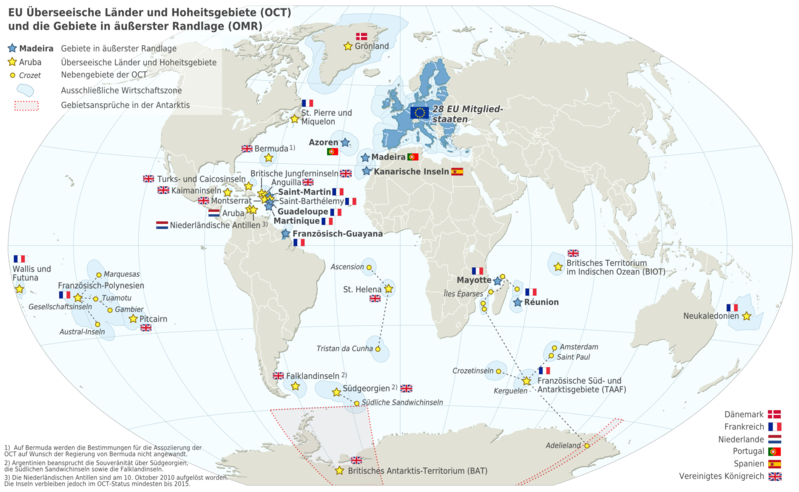
Deutsch: Karte der EU - Überseeische Länder und Hoheitsgebiete (OCT) und die Gebiete in äußerster Randlage (OMR). Diese Karte zeigt den räumlichen Geltungsbereich der Verträge der EU gemäß Artikel 52 des Vertrags über die Europäische Union und Artikel 355 des Vertrags über die Arbeitsweise der Europäischen Union.
Français : Carte de l’Union Européenne, en particulier les Pays et territoires d’outre-mer et les Régions ultrapériphériques. Cette carte montre la portée d’action territoriale des Traités de l’UE comme spécifié par l’Article 52 du Traité sur l’Union Européenne et l’Article 355 du Traité sur le Fonctionnement de l’Union Européenne.
English: Map of the EU - Overseas Countries and Territories (OCT) and Outermost Regions (OMR). This map shows the territorial scope of the Treaties of the EU as specified by Article 52 of the Treaty on European Union and Article 355 of the Treaty on the Functioning of the European Union. |
| Date | |
| Source | Natural Earth 1:50m (http://www.naturalearthdata.com) |
| Author | Alexrk2 |
| Other versions |
|


|
This map has been made or improved in the German Kartenwerkstatt (Map Lab). You can propose maps to improve as well.
|

|
This map of the world image could be re-created using vector graphics as an SVG file. This has several advantages; see Commons:Media for cleanup for more information. If an SVG form of this image is available, please upload it and afterwards replace this template with
{{vector version available|new image name}}.
It is recommended to name the SVG file “EU OCT and OMR map de.svg”—then the template Vector version available (or Vva) does not need the new image name parameter. |
Licensing[edit]
I, the copyright holder of this work, hereby publish it under the following license:
This file is licensed under the Creative Commons Attribution-Share Alike 3.0 Unported license.
- You are free:
- to share – to copy, distribute and transmit the work
- to remix – to adapt the work
- Under the following conditions:
- attribution – You must give appropriate credit, provide a link to the license, and indicate if changes were made. You may do so in any reasonable manner, but not in any way that suggests the licensor endorses you or your use.
- share alike – If you remix, transform, or build upon the material, you must distribute your contributions under the same or compatible license as the original.
File history
Click on a date/time to view the file as it appeared at that time.
| Date/Time | Thumbnail | Dimensions | User | Comment | |
|---|---|---|---|---|---|
| current | 17:05, 22 March 2018 | | 2,206 × 1,358 (1,021 KB) | Maphobbyist (talk | contribs) | De-jure Somalia border |
| 09:47, 9 September 2016 |  | 2,206 × 1,358 (944 KB) | AdAstraPerScientiam (talk | contribs) | Ausschließliche Wirtschaftszone Kroatien Grenze Südsudan ergänzt | |
| 15:11, 23 January 2014 |  | 2,206 × 1,358 (723 KB) | Kopiersperre (talk | contribs) | optipng | |
| 18:26, 1 January 2014 |  | 2,206 × 1,358 (1.03 MB) | Alexrk2 (talk | contribs) | minor | |
| 18:20, 1 January 2014 |  | 2,206 × 1,358 (1.03 MB) | Alexrk2 (talk | contribs) | From 1 January 2014, the status of Mayotte will be that of an outermost region (COUNCIL DIRECTIVE 2013/61/EU of 17 December 2013) | |
| 17:46, 30 June 2013 |  | 2,206 × 1,358 (1.05 MB) | Alexrk2 (talk | contribs) | + Croatia | |
| 17:36, 17 October 2012 |  | 2,206 × 1,358 (1.05 MB) | Alexrk2 (talk | contribs) | As from 1 January 2012, the French Outermost region, Saint Barthelemy (St. Barth), will, following a decision of the European Council, change its status from Outermost Region to OCT | |
| 21:38, 26 April 2011 |  | 2,206 × 1,358 (1.05 MB) | Alexrk2 (talk | contribs) | typos, kleinigkeiten | |
| 17:21, 24 April 2011 |  | 2,206 × 1,358 (1.05 MB) | Alexrk2 (talk | contribs) | - | |
| 17:00, 24 April 2011 |  | 2,206 × 1,358 (1.07 MB) | Alexrk2 (talk | contribs) | {{Information |Description= {{de|Karte der EU - Überseeische Länder und Hoheitsgebiete (OCT) und die Gebiete in äußerster Randlage (OMR). Diese Karte zeigt den räumlichen Geltungsbereich der Verträge der EU gemäß Artikel 52 des Vertrags über die |
You cannot overwrite this file.
File usage on Commons
The following page uses this file:
File usage on other wikis
The following other wikis use this file:
- Usage on de.wikipedia.org
- Usage on pdc.wikipedia.org