File:Electoral map 2004-2008.svg
(Redirected from File:Electoral map.svg)

Size of this PNG preview of this SVG file: 800 × 495 pixels. Other resolutions: 320 × 198 pixels | 640 × 396 pixels | 1,024 × 633 pixels | 1,280 × 791 pixels | 2,560 × 1,583 pixels | 959 × 593 pixels.
Original file (SVG file, nominally 959 × 593 pixels, file size: 515 KB)
Captions
Captions
Add a one-line explanation of what this file represents
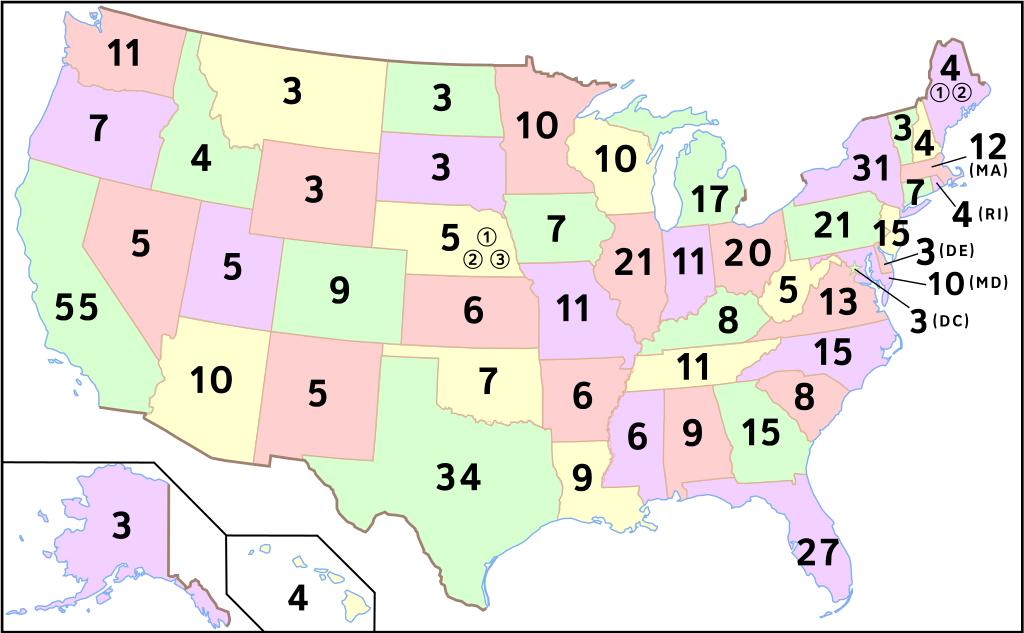
Summary[edit]
| Description | Map of number of electoral votes by state after redistricting from the 2000 census. Modified by User:Theshibboleth for the font to be consistent with electoral maps. Edited with Inkscape. Reuploaded by User:King of Hearts to correct spelling (vs. Electorial map.svg). |
| Date | |
| Source | Self-made by User:Scott5114, based on Image:Map of USA with state names.svg. |
| Author | Scott5114 |
| Other versions |
|
| SVG development |

Licensing[edit]

|
Permission is granted to copy, distribute and/or modify this document under the terms of the GNU Free Documentation License, Version 1.2 or any later version published by the Free Software Foundation; with no Invariant Sections, no Front-Cover Texts, and no Back-Cover Texts. A copy of the license is included in the section entitled GNU Free Documentation License. |
| This file is licensed under the Creative Commons Attribution-Share Alike 3.0 Unported license. | ||
| ||
| This licensing tag was added to this file as part of the GFDL licensing update. |
This file is licensed under the Creative Commons Attribution-Share Alike 3.0 Unported, 2.5 Generic, 2.0 Generic and 1.0 Generic license.
- You are free:
- to share – to copy, distribute and transmit the work
- to remix – to adapt the work
- Under the following conditions:
- attribution – You must give appropriate credit, provide a link to the license, and indicate if changes were made. You may do so in any reasonable manner, but not in any way that suggests the licensor endorses you or your use.
- share alike – If you remix, transform, or build upon the material, you must distribute your contributions under the same or compatible license as the original.
File history
Click on a date/time to view the file as it appeared at that time.
| Date/Time | Thumbnail | Dimensions | User | Comment | |
|---|---|---|---|---|---|
| current | 22:11, 12 December 2011 | | 959 × 593 (515 KB) | Kilopi (talk | contribs) | fixed Maine |
| 23:29, 29 July 2011 |  | 959 × 593 (518 KB) | Scott5114 (talk | contribs) | Update to merge in changes from a PNG version of this file on Wikipedia (showing congressional district electoral votes for Maine and Nebraska) | |
| 15:17, 23 May 2007 |  | 959 × 593 (482 KB) | King of Hearts (talk | contribs) | == Summary == {{Information| |Description=Map of number of electoral votes by state after redistricting from the 2000 census. Modified by User:Theshibboleth for the font to be consistent with electoral maps. Edited with Inkscape. Reuploaded by [[User: |
You cannot overwrite this file.
File usage on Commons
The following 7 pages use this file:
File usage on other wikis
The following other wikis use this file:
- Usage on af.wikipedia.org
- Usage on ar.wikipedia.org
- Usage on arz.wikipedia.org
- Usage on de.wikipedia.org
- Usage on en.wikipedia.org
- Usage on fr.wikipedia.org
- Usage on fr.wikinews.org
- Usage on he.wikipedia.org
- Usage on id.wikipedia.org
- Usage on it.wikiquote.org
- Usage on ms.wikipedia.org
- Usage on nl.wikipedia.org
- Usage on pl.wikipedia.org
- Usage on pt.wikipedia.org
- Usage on ro.wikipedia.org
- Usage on sh.wikipedia.org
- Usage on sq.wikipedia.org
- Usage on sr.wikipedia.org
- Usage on tr.wikipedia.org
- Usage on vi.wikipedia.org
- Usage on www.wikidata.org
- Usage on wuu.wikipedia.org
- Usage on yi.wikipedia.org
- Usage on zh-yue.wikipedia.org
- Usage on zh.wikipedia.org