File:EtoshaBorders.jpg
Jump to navigation
Jump to search
Size of this preview: 800 × 365 pixels. Other resolutions: 320 × 146 pixels | 640 × 292 pixels | 1,406 × 642 pixels.
Original file (1,406 × 642 pixels, file size: 276 KB, MIME type: image/jpeg)
Captions
Captions
Add a one-line explanation of what this file represents
Summary[edit]
| Description |
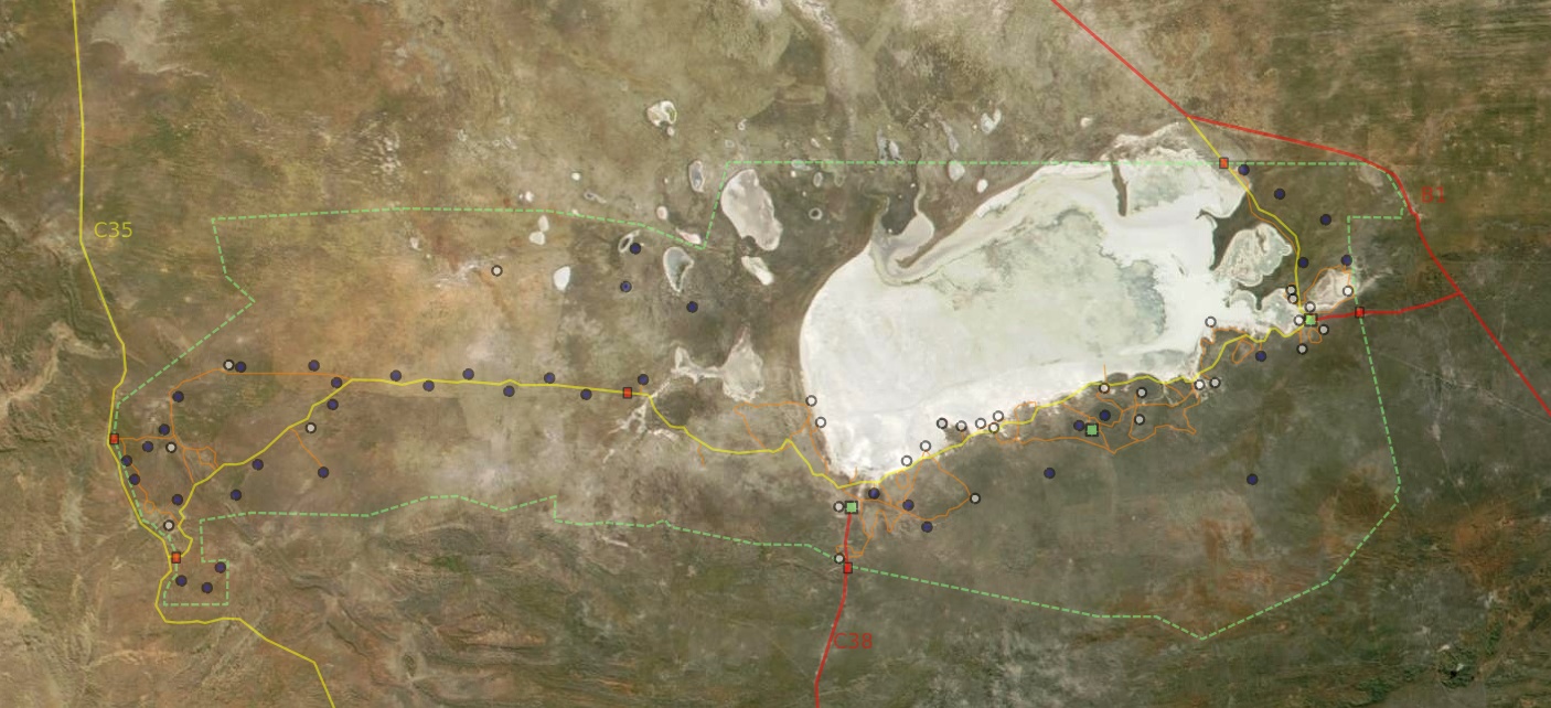
Deutsch: Satellitenbild vom Etosha Park mit Grenzen, Wegen, Wasserstellen, Camps und Toren
English: Satellite picture of Etosha park with borders, roads, waterpoints, camps and gates
Français : Vue satellite de la réserve naturelle d'Etosha, avec les limites, chemins, points d'eau, camps et portes
English: Satellite picture of the park
Français : Vue satellite du parc naturel d'Etosha
Suomi: Etoshan kansallispuisto satelliittikuvassa |
| Date | |
| Source | NASA |
| Author | Modified by Harald Süpfle |
| Permission (Reusing this file) |
NASA public domain |
| Other versions | cut out of original NASA file (3600x4800): ev11707_Namibia.A2001131.0920.250m.jpg |
Licensing[edit]
| This file is in the public domain in the United States because it was solely created by NASA. NASA copyright policy states that "NASA material is not protected by copyright unless noted". (See Template:PD-USGov, NASA copyright policy page or JPL Image Use Policy.) | ||
 |
Warnings:
|
File history
Click on a date/time to view the file as it appeared at that time.
| Date/Time | Thumbnail | Dimensions | User | Comment | |
|---|---|---|---|---|---|
| current | 22:39, 18 December 2006 | | 1,406 × 642 (276 KB) | Hsuepfle (talk | contribs) | {{Created with Inkscape}} {{Information| |Description = '''de:''' Satellitenbild vom Etosha Park mit Grenzen, Wegen, Wasserstellen, Camps und Toren * rote linie: Teerstraße * gelbe Linie: Piste * Rotes Quadrat: Parktor * Grünes Quadrat: Camp * Blauer K |
| 22:47, 6 January 2006 |  | 1,150 × 504 (176 KB) | Hsuepfle (talk | contribs) | {{Information| |Description = de: Satellitenbild vom Etosha Park mit Grenzen, Wegen, Wasserlöchern, Camps und Toren en: Satellite picture of Etosha park with borders, roads, Water holes, Camps and Gates |Source = NASA |Date = 2006-01-06 |Author = Modif |
You cannot overwrite this file.
File usage on Commons
The following 2 pages use this file:
File usage on other wikis
The following other wikis use this file:
- Usage on af.wikipedia.org
- Usage on be.wikipedia.org
- Usage on bg.wikipedia.org
- Usage on de.wikipedia.org
- Usage on en.wikipedia.org
- Usage on eo.wikipedia.org
- Usage on es.wikipedia.org
- Usage on fi.wikipedia.org
- Usage on hu.wikipedia.org
- Usage on it.wikipedia.org
- Usage on lt.wikipedia.org
- Usage on no.wikipedia.org
- Usage on pnb.wikipedia.org
- Usage on sk.wikipedia.org
- Usage on sl.wikipedia.org
- Usage on vi.wikipedia.org
- Usage on zh.wikipedia.org