File:Europe countries map it 2.png
Jump to navigation
Jump to search
Size of this preview: 737 × 600 pixels. Other resolutions: 295 × 240 pixels | 590 × 480 pixels | 944 × 768 pixels | 1,259 × 1,024 pixels | 1,475 × 1,200 pixels.
Original file (1,475 × 1,200 pixels, file size: 833 KB, MIME type: image/png)
Captions
Captions
Add a one-line explanation of what this file represents
Summary[edit]
| Description |
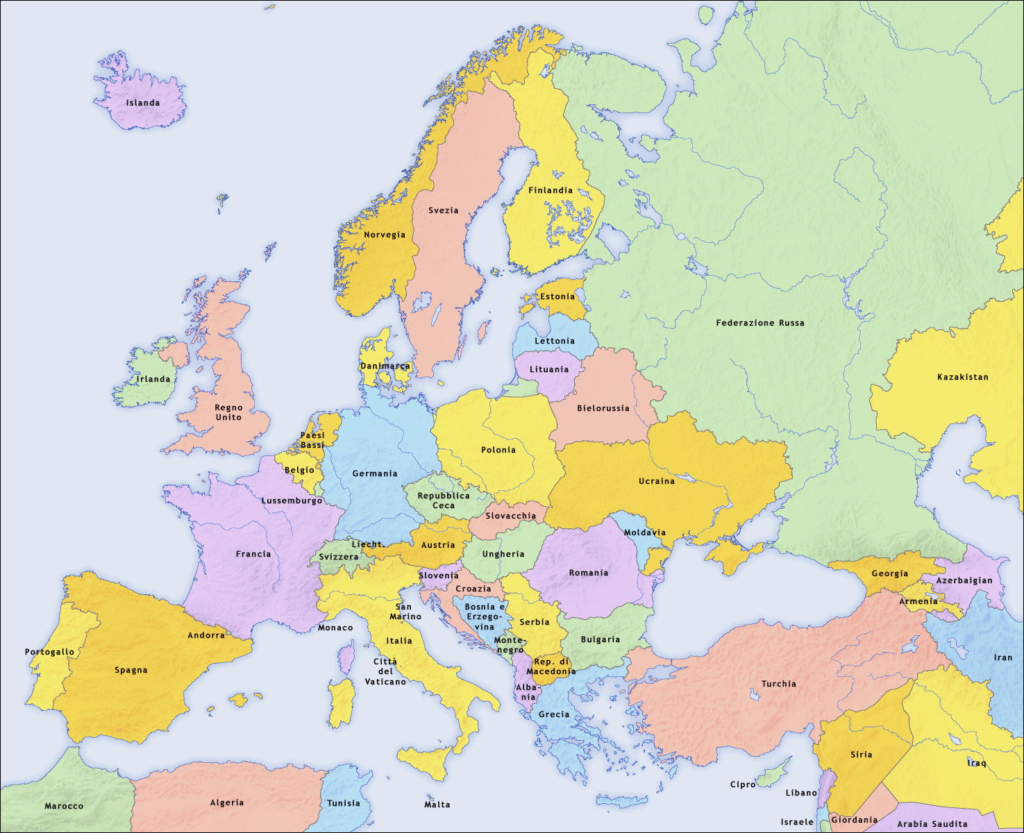
English: Map of countries in Europe and the surrounding region |
||||||||||
| Date | 02.04.2006 | ||||||||||
| Source | derivative work of Europe countries map it.png by San Jose, based on the Generic Mapping Tools and ETOPO2 | ||||||||||
| Author | San Jose (map), Hayden120 (retouch) | ||||||||||
| Permission (Reusing this file) |
|
||||||||||
| Other versions |
[]
|


| This is a retouched picture, which means that it has been digitally altered from its original version. Modifications: Saturation, brightness, contrast. The original can be viewed here: Europe countries map it.png:
|
See also[edit]
_en.png)
.png)
.jpg)
File history
Click on a date/time to view the file as it appeared at that time.
| Date/Time | Thumbnail | Dimensions | User | Comment | |
|---|---|---|---|---|---|
| current | 08:09, 11 September 2009 | | 1,475 × 1,200 (833 KB) | Hayden120 (talk | contribs) | == {{int:filedesc}} == {{Information |Description= {{en|Map of countries in Europe}} |Source=derivative work of Europe countries map it.png by San Jose, based on the [http://gmt.soest.hawaii.edu/ Gen |
You cannot overwrite this file.
File usage on Commons
The following 54 pages use this file:
- File:Europan.png
- File:Europe countries map-zh-classical.png
- File:Europe countries map.png
- File:Europe countries map 2.png
- File:Europe countries map 2 hr.svg
- File:Europe countries map af.png
- File:Europe countries map ar 2.png
- File:Europe countries map bg.png
- File:Europe countries map bs.png
- File:Europe countries map ce.svg
- File:Europe countries map cs.png
- File:Europe countries map cs2.svg
- File:Europe countries map de.png
- File:Europe countries map de 2.png
- File:Europe countries map dsb.PNG
- File:Europe countries map en.png
- File:Europe countries map en 2.png
- File:Europe countries map eo.png
- File:Europe countries map es.png
- File:Europe countries map et.png
- File:Europe countries map fo.png
- File:Europe countries map fr.png
- File:Europe countries map fr 2.png
- File:Europe countries map gd.png
- File:Europe countries map got.png
- File:Europe countries map hsb.PNG
- File:Europe countries map hu.png
- File:Europe countries map it.png
- File:Europe countries map it 2.png
- File:Europe countries map ja.png
- File:Europe countries map ja 2.png
- File:Europe countries map km.png
- File:Europe countries map km 2.png
- File:Europe countries map la.png
- File:Europe countries map local lang.png
- File:Europe countries map local lang 2.png
- File:Europe countries map lt.png
- File:Europe countries map lv.png
- File:Europe countries map mn.png
- File:Europe countries map nah.png
- File:Europe countries map pl.png
- File:Europe countries map ru.png
- File:Europe countries map ru edited-1.png
- File:Europe countries map sk.png
- File:Europe countries map sl.png
- File:Europe countries map sq.png
- File:Europe countries map sr.png
- File:Europe countries map szl.png
- File:Europe countries map szl 2.png
- File:Europe countries map tg.png
- File:Europe countries map tr.png
- File:Europe countries map uk.png
- File:Europe countries map wo.PNG
- Template:Other versions/Europe countries map