File:Exacta totius Americæ tabula - Kungliga Biblioteket - 10398124.tif
Jump to navigation
Jump to search

Size of this JPG preview of this TIF file: 800 × 599 pixels. Other resolutions: 320 × 239 pixels | 640 × 479 pixels | 1,024 × 766 pixels | 1,280 × 958 pixels | 2,560 × 1,915 pixels | 10,232 × 7,656 pixels.
Original file (10,232 × 7,656 pixels, file size: 448.29 MB, MIME type: image/tiff, 2 pages)
Captions
Captions
Add a one-line explanation of what this file represents
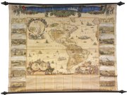
| Title |
Exacta totius Americæ tabula |
||||||||||||||||||||||||||
| Description |
Svenska: Schematisk topografi. - Orter utsatta. - Med beskriving och 12 stadsvyer |
||||||||||||||||||||||||||
| Source |
|
||||||||||||||||||||||||||
| Creator |
|
||||||||||||||||||||||||||
| Permission (Reusing this file) |
Per the source the digitisations are under
|
||||||||||||||||||||||||||
| Geotemporal data | |||||||||||||||||||||||||||
| Date depicted | 17th century | ||||||||||||||||||||||||||
| Map location |
Svenska: Amerika (kontinent) |
||||||||||||||||||||||||||
| Scale | 1:11,000,000 | ||||||||||||||||||||||||||
| Bounding box |
|
||||||||||||||||||||||||||
| Georeferencing | If inappropriate please set warp_status = skip to hide. | ||||||||||||||||||||||||||
| Bibliographic data | |||||||||||||||||||||||||||
| Map sheet | 1 karta | ||||||||||||||||||||||||||
| Language |
|
||||||||||||||||||||||||||
| Publisher |
Nicolaum Visscher, Amstelodami, Netherlands |
||||||||||||||||||||||||||
| Archival data | |||||||||||||||||||||||||||
| Collection |
|
||||||||||||||||||||||||||
| Accession number |
10398124 |
||||||||||||||||||||||||||
| Dimensions | ca 150 x 185 cm | ||||||||||||||||||||||||||
| Medium | kopparstick, handkolorerad, monterad på stavar | ||||||||||||||||||||||||||
| Notes |
Väggkarta
|
||||||||||||||||||||||||||
| Other versions |
 |
||||||||||||||||||||||||||

File history
Click on a date/time to view the file as it appeared at that time.
| Date/Time | Thumbnail | Dimensions | User | Comment | |
|---|---|---|---|---|---|
| current | 16:10, 21 January 2015 |  | 10,232 × 7,656, 2 pages (448.29 MB) | L PBot (talk | contribs) | {{subst:User:André_Costa_(WMSE)/KB-map |title = Exacta totius Americæ tabula |description = {{sv|Schematisk topografi. - Orter utsatta. - Med beskriving och 12 stadsvyer}} |author = * Nicolaes Visscher (1649-1702; '''creator... |
You cannot overwrite this file.
File usage on Commons
The following 3 pages use this file: