File:FRONT, LOOKING SOUTHEAST - Naval Operating Base Dutch Harbor and Fort Mears, Beer Hall, Unalaska, Aleutian Islands, AK HABS AK,1-UNAK,2-G-2.tif
Jump to navigation
Jump to search

Size of this JPG preview of this TIF file: 754 × 600 pixels. Other resolutions: 302 × 240 pixels | 603 × 480 pixels | 965 × 768 pixels | 1,280 × 1,018 pixels | 2,560 × 2,037 pixels | 4,923 × 3,917 pixels.
Original file (4,923 × 3,917 pixels, file size: 18.39 MB, MIME type: image/tiff)
Captions
Captions
Add a one-line explanation of what this file represents
Summary[edit]
| FRONT, LOOKING SOUTHEAST - Naval Operating Base Dutch Harbor and Fort Mears, Beer Hall, Unalaska, Aleutian Islands, AK | ||||
|---|---|---|---|---|
| Title |
FRONT, LOOKING SOUTHEAST - Naval Operating Base Dutch Harbor and Fort Mears, Beer Hall, Unalaska, Aleutian Islands, AK |
|||
| Date | Documentation compiled after 1933 | |||
| Medium | 4 x 5 in. | |||
| Current location |
Library of Congress Prints and Photographs Division Washington, D.C. 20540 USA http://hdl.loc.gov/loc.pnp/pp.print |
|||
| Accession number |
HABS AK,1-UNAK,2-G-2 |
|||
| Place of creation | Alaska; Aleutian Islands; Unalaska | |||
| Credit line |
|
|||
| Notes |
|
|||
| References |
|
|||
| Source/Photographer | https://www.loc.gov/pictures/item/ak0146.photos.000194p | |||
| Permission (Reusing this file) |
|
|||

| Object location | | View this and other nearby images on: OpenStreetMap |
|---|
File history
Click on a date/time to view the file as it appeared at that time.
| Date/Time | Thumbnail | Dimensions | User | Comment | |
|---|---|---|---|---|---|
| current | 00:49, 25 June 2014 | 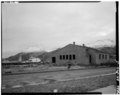 | 4,923 × 3,917 (18.39 MB) | Fæ (talk | contribs) | GWToolset: Creating mediafile for Fæ. HABS batch uploads start 24 June 2014 |
You cannot overwrite this file.
File usage on Commons
The following page uses this file: