File:Finale Ligure - Savona - Italia - 2005 - Ciappo conche approccio.jpg
Finale_Ligure_-_Savona_-_Italia_-_2005_-_Ciappo_conche_approccio.jpg (425 × 391 pixels, file size: 38 KB, MIME type: image/jpeg)
Captions
Captions
Object[edit]
Finale Ligure - Savona - Italia - 2005 - Ciappo conche approccio
Summary[edit]
| Description |
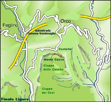
Italiano: Da Finale Ligure si prende la carrozzabile per Orco Feglino, quando si arriva a Nord del Monte Cucco, c’è una cava vicino alla località Castello e si lascia l’auto.
Dalla strada al Ciappo delle Conche c’è una distanza di circa 600 metri che si copre a piedi in 30 minuti. Dalla cava si prosegue a piedi per breve tratto, circa 100 metri verso Sud Est, tenendo d’occhio una mulattiera (solitamente segnalata da tre bolli rossi affiancati), che si diparte sulla destra e che sale direttamente lungo la parete Nord sul Monte Cucco, per un dislivello di 80 metri. Arrivati in cima la mulattiera finisce e si prosegue su un sentiero che va degradando verso Sud e dopo breve si incontra il Ciappo delle Conche, che si riconosce per essere un ampio spiazzo con una vasca larga circa un metro quadrato.English: From Finale Ligure take the road for Orco Feglino, when it comes to the north of Mount Cucco, a quarry near the town Castle and leave the car.
From road to Ciappo of Conche there is a distance of 600 meters and is covered on foot in 30 minutes. From the quarry continue on foot for short, about 100 meters south east, keeping an eye on a mule track (usually indicated by three red-backed stamps), which departs on the right and that goes directly along the north wall on Mount Cucco, for a drop of 80 meters. Arrived at the top of the path ends and continue on a path that goes down to the South and after you meet the short Ciappo of Conche, which is recognized to be a large plaza with a large tub about one square meter.Español: Finale Ligure de tomar el camino de Orco Feglino, en lo que se refiere al norte del Monte Cucco, una cantera cerca de la ciudad Castillo y dejar el coche.
De la carretera al Ciappo de Conche hay una distancia de 600 metros y está cubierto a pie en 30 minutos. De la cantera y seguir a pie a corto, a unos 100 metros al sureste, manteniendo un ojo en un camino de mula (por lo general, se indica por tres sellos de color rojo-el respaldo), que sale a la derecha y que va directamente a lo largo de la pared norte del Monte Cucco, para una caída de 80 metros. Llegó a la cima de la ruta y termina en seguir un camino que baja hacia el sur y después de atender a corto Ciappo de Conche, que es reconocida como una gran plaza con una gran bañera alrededor de un metro cuadrado. |
||
| Date | 5 set 2005 , 23:38 | ||
| Source | Istituto Geografico Militare, cartina 1:25.000, 92 I SE, Finale Ligure | ||
| Author | roger469 | ||
| Permission (Reusing this file) |
|
| Camera location | | View this and other nearby images on: OpenStreetMap |
|---|
Link to page[edit]
File history
Click on a date/time to view the file as it appeared at that time.
| Date/Time | Thumbnail | Dimensions | User | Comment | |
|---|---|---|---|---|---|
| current | 22:19, 5 September 2005 | | 425 × 391 (38 KB) | Roger469 (talk | contribs) | Finale Ligure - Savona - Italia - 2005 - Ciappo conche approccio |
You cannot overwrite this file.
File usage on Commons
There are no pages that use this file.
File usage on other wikis
The following other wikis use this file:
- Usage on it.wikipedia.org