File:Finland national road 20.png
Jump to navigation
Jump to search

Size of this preview: 341 × 600 pixels. Other resolutions: 136 × 240 pixels | 455 × 800 pixels.
Original file (455 × 800 pixels, file size: 109 KB, MIME type: image/png)
Captions
Captions
Add a one-line explanation of what this file represents

|
This road map image could be re-created using vector graphics as an SVG file. This has several advantages; see Commons:Media for cleanup for more information. If an SVG form of this image is available, please upload it and afterwards replace this template with
{{vector version available|new image name}}.
It is recommended to name the SVG file “Finland national road 20.svg”—then the template Vector version available (or Vva) does not need the new image name parameter. |
Summary[edit]
| Description |
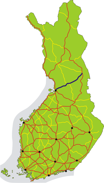
English: Map of the main road 20 in Finland, shown in dark blue. The other 1st class main roads (numbers 1–29) are red, 2nd class main roads (numbers 40–98) yellow. Black dots show the 12 biggest urban areas.
Suomi: Valtatie 20 on merkitty karttaan tummansinisellä. Muut valtatiet (numerot 1–29) on merkitty karttaan punaisella, kantatiet (numerot 40–98) keltaisella. Tärkeimmät kaupunkiseudut on merkitty mustilla pisteillä. |
| Date | |
| Source | Own work |
| Author | Migro |
Licensing[edit]
| I, the copyright holder of this work, release this work into the public domain. This applies worldwide. In some countries this may not be legally possible; if so: I grant anyone the right to use this work for any purpose, without any conditions, unless such conditions are required by law. |
File history
Click on a date/time to view the file as it appeared at that time.
| Date/Time | Thumbnail | Dimensions | User | Comment | |
|---|---|---|---|---|---|
| current | 21:06, 1 July 2007 | | 455 × 800 (109 KB) | Migro (talk | contribs) | == Summary == {{Information |Description=Map of main road 20 in Finland, shown in dark blue. Roads number 1-29 are red, 40-98 are yellow. Black dots show the 12 biggest urban areas. |Source=self-made |Date=2007-07-01 |Author= Migro }} [[C |
You cannot overwrite this file.
File usage on Commons
The following page uses this file:
File usage on other wikis
The following other wikis use this file:
- Usage on cs.wikipedia.org
- Usage on de.wikipedia.org
- Usage on fi.wikipedia.org
- Usage on fr.wikipedia.org
- Usage on it.wikipedia.org
- Usage on lmo.wikipedia.org
- Usage on sv.wikipedia.org
- Usage on www.wikidata.org