File:First Methodist Episcopal Church, Valley and Jewett Streets (moved from NH, Derryville), Manchester, Hillsborough County, NH HABS NH,6-MANCH,1- (sheet 13 of 16).tif
Jump to navigation
Jump to search

Size of this JPG preview of this TIF file: 488 × 599 pixels. Other resolutions: 195 × 240 pixels | 391 × 480 pixels | 625 × 768 pixels | 834 × 1,024 pixels | 1,667 × 2,048 pixels | 7,584 × 9,316 pixels.
Original file (7,584 × 9,316 pixels, file size: 495 KB, MIME type: image/tiff)
Captions
Captions
Add a one-line explanation of what this file represents
Summary[edit]
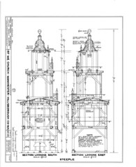
| HABS NH,6-MANCH,1- (sheet 13 of 16) - First Methodist Episcopal Church, Valley and Jewett Streets (moved from NH, Derryville), Manchester, Hillsborough County, NH | ||||
|---|---|---|---|---|
| Title |
HABS NH,6-MANCH,1- (sheet 13 of 16) - First Methodist Episcopal Church, Valley and Jewett Streets (moved from NH, Derryville), Manchester, Hillsborough County, NH |
|||
| Depicted place | New Hampshire; Hillsborough County; Manchester | |||
| Date | Documentation compiled after 1933 | |||
| Dimensions | 19 x 24 in. (B size) | |||
| Current location |
Library of Congress Prints and Photographs Division Washington, D.C. 20540 USA http://hdl.loc.gov/loc.pnp/pp.print |
|||
| Accession number |
HABS NH,6-MANCH,1- (sheet 13 of 16) |
|||
| Credit line |
|
|||
| Notes |
|
|||
| Source | https://www.loc.gov/pictures/item/nh0140.sheet.00013a | |||
| Permission (Reusing this file) |
|
|||
| Other versions |
,_Manchester,_Hillsborough_County,_NH_HABS_NH,6-MANCH,1-_(sheet_0_of_16).png) ,_Manchester,_Hillsborough_County,_NH_HABS_NH,6-MANCH,1-_(sheet_1_of_16).png) ,_Manchester,_Hillsborough_County,_NH_HABS_NH,6-MANCH,1-_(sheet_10_of_16).png) ,_Manchester,_Hillsborough_County,_NH_HABS_NH,6-MANCH,1-_(sheet_11_of_16).png) ,_Manchester,_Hillsborough_County,_NH_HABS_NH,6-MANCH,1-_(sheet_12_of_16).png) ,_Manchester,_Hillsborough_County,_NH_HABS_NH,6-MANCH,1-_(sheet_13_of_16).png) ,_Manchester,_Hillsborough_County,_NH_HABS_NH,6-MANCH,1-_(sheet_14_of_16).png) ,_Manchester,_Hillsborough_County,_NH_HABS_NH,6-MANCH,1-_(sheet_15_of_16).png) ,_Manchester,_Hillsborough_County,_NH_HABS_NH,6-MANCH,1-_(sheet_16_of_16).png) ,_Manchester,_Hillsborough_County,_NH_HABS_NH,6-MANCH,1-_(sheet_2_of_16).png) ,_Manchester,_Hillsborough_County,_NH_HABS_NH,6-MANCH,1-_(sheet_3_of_16).png) ,_Manchester,_Hillsborough_County,_NH_HABS_NH,6-MANCH,1-_(sheet_4_of_16).png) ,_Manchester,_Hillsborough_County,_NH_HABS_NH,6-MANCH,1-_(sheet_5_of_16).png) ,_Manchester,_Hillsborough_County,_NH_HABS_NH,6-MANCH,1-_(sheet_6_of_16).png) ,_Manchester,_Hillsborough_County,_NH_HABS_NH,6-MANCH,1-_(sheet_7_of_16).png) ,_Manchester,_Hillsborough_County,_NH_HABS_NH,6-MANCH,1-_(sheet_8_of_16).png) ,_Manchester,_Hillsborough_County,_NH_HABS_NH,6-MANCH,1-_(sheet_9_of_16).png) |
|||

| Object location | | View this and other nearby images on: OpenStreetMap |
|---|
File history
Click on a date/time to view the file as it appeared at that time.
| Date/Time | Thumbnail | Dimensions | User | Comment | |
|---|---|---|---|---|---|
| current | 04:13, 29 July 2014 |  | 7,584 × 9,316 (495 KB) | Fæ (talk | contribs) | GWToolset: Creating mediafile for Fæ. HABS 24 July 2014 (2001:2300) |
You cannot overwrite this file.
File usage on Commons
The following page uses this file: