File:Footbridge taking Speyside Way over old railway bridge - geograph.org.uk - 324492.jpg
Jump to navigation
Jump to search
No higher resolution available.
Footbridge_taking_Speyside_Way_over_old_railway_bridge_-_geograph.org.uk_-_324492.jpg (640 × 480 pixels, file size: 101 KB, MIME type: image/jpeg)
Captions
Captions
Add a one-line explanation of what this file represents
Summary[edit]
| Description |
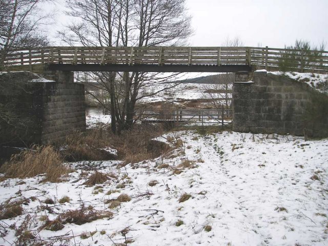
English: Footbridge taking Speyside Way over old railway bridge The Speyside Way, a long distance footpath, follows a dismantled railway for some miles parallel to the River Spey. Here the buttresses of the old railway bridge are still present, but they carry just a small footbridge of the Speyside Way across a small tributary (the Auchernach burn) of the Spey. The River Spey itself is just visible beyond the bridge. |
| Date | |
| Source | From geograph.org.uk |
| Author | Roy Turnbull |
| Attribution (required by the license) | Roy Turnbull / Footbridge taking Speyside Way over old railway bridge / |
| Camera location | | View this and other nearby images on: OpenStreetMap |
|---|
_heading:270.00&language=en)
| Object location | | View this and other nearby images on: OpenStreetMap |
|---|
_heading:270.00&language=en)
Licensing[edit]

|
This image was taken from the Geograph project collection. See this photograph's page on the Geograph website for the photographer's contact details. The copyright on this image is owned by Roy Turnbull and is licensed for reuse under the Creative Commons Attribution-ShareAlike 2.0 license.
|
This file is licensed under the Creative Commons Attribution-Share Alike 2.0 Generic license.
Attribution: Roy Turnbull
- You are free:
- to share – to copy, distribute and transmit the work
- to remix – to adapt the work
- Under the following conditions:
- attribution – You must give appropriate credit, provide a link to the license, and indicate if changes were made. You may do so in any reasonable manner, but not in any way that suggests the licensor endorses you or your use.
- share alike – If you remix, transform, or build upon the material, you must distribute your contributions under the same or compatible license as the original.
File history
Click on a date/time to view the file as it appeared at that time.
| Date/Time | Thumbnail | Dimensions | User | Comment | |
|---|---|---|---|---|---|
| current | 18:38, 30 December 2010 | | 640 × 480 (101 KB) | GeographBot (talk | contribs) | == {{int:filedesc}} == {{Information |description={{en|1=Footbridge taking Speyside Way over old railway bridge The Speyside Way, a long distance footpath, follows a dismantled railway for some miles parallel to the River Spey. Here the buttresses of the |
You cannot overwrite this file.
File usage on Commons
There are no pages that use this file.