File:France geological map-fr.svg
Jump to navigation
Jump to search

Size of this PNG preview of this SVG file: 559 × 599 pixels. Other resolutions: 224 × 240 pixels | 448 × 480 pixels | 717 × 768 pixels | 956 × 1,024 pixels | 1,911 × 2,048 pixels | 1,636 × 1,753 pixels.
Original file (SVG file, nominally 1,636 × 1,753 pixels, file size: 3.27 MB)
Captions
Captions
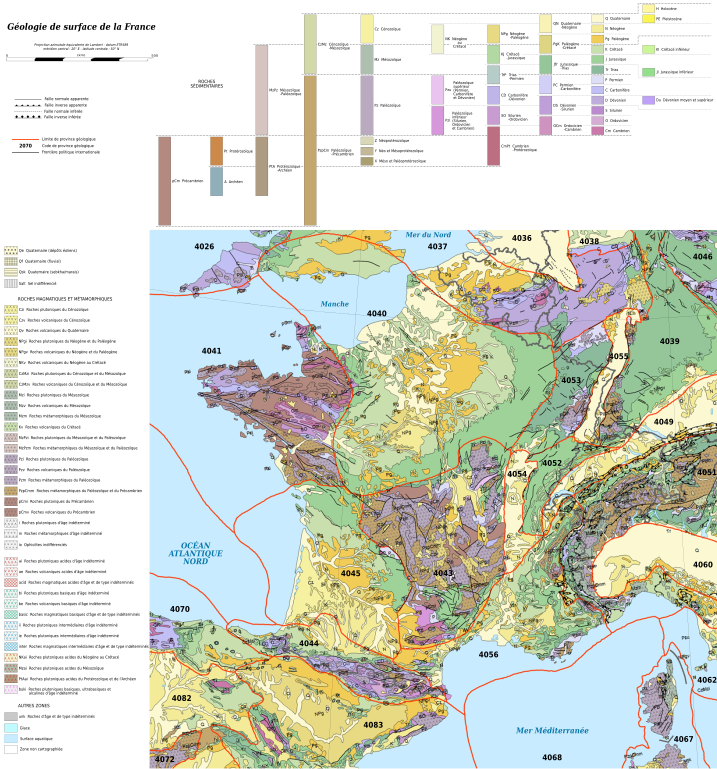
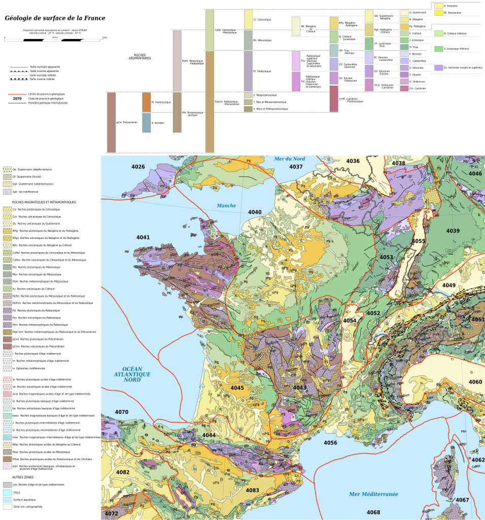
Geological map of France
Summary[edit]
| Description |
English: Map in French of the surficial geology of France. Notes: *The background map is a raster PNG image embedded in the SVG file. *Each geology province is classified and named in the XML code of the SVG file. *A list of the names corresponding to the geologic provinces codes displayed on the map can be viewed on the discussion page. Français : Carte en français de la géologie de la France. Notes : *Le fond de carte est une image bitmap PNG embarquée dans le fichier SVG. *Chaque province géologique est classée et nommée dans le code XML du fichier SVG. *Une liste des noms anglophones correspondant aux codes des provinces géologiques de la carte peut être consultée sur la page de discussion. Scale 1:5,000,000 |
||
| Date | (UTC) | ||
| Source |
This file was derived from: Europe geological map-en.svg:  |
||
| Author |
|
||
| Other versions | |||
| SVG | W3C-validity not checked.
|
||
| Graphic Lab |

Licensing[edit]
I, the copyright holder of this work, hereby publish it under the following license:
This file is licensed under the Creative Commons Attribution-Share Alike 3.0 Unported license.
- You are free:
- to share – to copy, distribute and transmit the work
- to remix – to adapt the work
- Under the following conditions:
- attribution – You must give appropriate credit, provide a link to the license, and indicate if changes were made. You may do so in any reasonable manner, but not in any way that suggests the licensor endorses you or your use.
- share alike – If you remix, transform, or build upon the material, you must distribute your contributions under the same or compatible license as the original.
Original upload log[edit]
This image is a derivative work of the following images:
- File:Europe_geological_map-en.svg licensed with Cc-by-sa-3.0
- 2010-08-13T17:48:23Z Sting 5408x5504 (30195899 Bytes) == {{int:filedesc}} == {{Location|60|00|00|N|20|00|00|E|scale:20000000}} {{Information| |Description={{en|Map in English of the surficial [[:en:geology of Europe|geology of Europe]].''Notes: The background map is a raster PN
Uploaded with derivativeFX
File history
Click on a date/time to view the file as it appeared at that time.
| Date/Time | Thumbnail | Dimensions | User | Comment | |
|---|---|---|---|---|---|
| current | 15:08, 26 May 2014 | | 1,636 × 1,753 (3.27 MB) | Sémhur (talk | contribs) | Valid SVG |
| 20:03, 29 July 2012 |  | 1,636 × 1,753 (3.27 MB) | Sémhur (talk | contribs) | Minor corrections | |
| 18:56, 29 July 2012 |  | 1,636 × 1,753 (3.26 MB) | Sémhur (talk | contribs) | == {{int:filedesc}} == {{Information |Description={{Multilingual description |en= Map in French of the surficial en:geology of France.}} ''Notes:''<br/> *''The background map is a raster PNG image embedded in the SVG file.''<br/> *''Each geology ... |
You cannot overwrite this file.
File usage on Commons
The following 3 pages use this file:
File usage on other wikis
The following other wikis use this file:
- Usage on de.wikipedia.org
- Usage on el.wikipedia.org
- Usage on en.wikipedia.org
- Usage on fr.wikipedia.org
- Usage on fr.wiktionary.org
- Usage on ro.wikipedia.org
- Usage on uk.wikipedia.org
Metadata
Categories:
- Geological maps of France
- French-language SVG maps
- Geological maps of Spain
- Geological maps of Andorra
- Geological maps of the Pyrenees
- Geological maps of Belgium
- Geological maps of Germany
- Geological maps of the Alps
- Geological maps of Switzerland
- Geological maps of Italy
- Geological maps of Corsica
- Geological maps of Baden-Württemberg
- Geological maps of Luxembourg
- Geological maps of England
- Geological maps of the Netherlands