File:Franklin 2 (6).jpg
Original file (912 × 387 pixels, file size: 106 KB, MIME type: image/jpeg)
Captions
Captions
Summary[edit]
.jpg&action=edit§ion=1)
| Description |
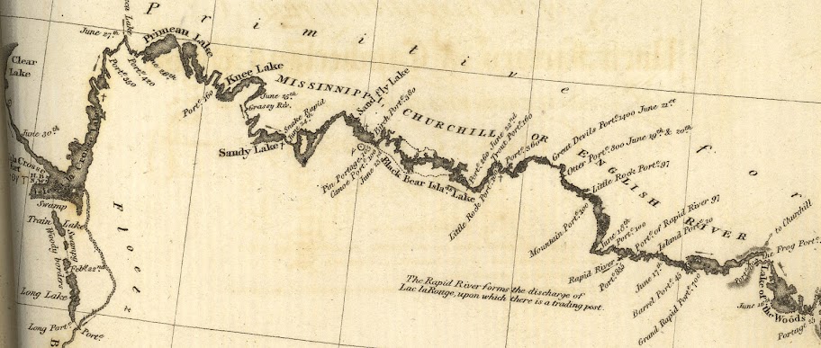
English: This is a portion of the map described below.
Route of the Expedition from York Factory to Cumberland House and the Summer & Winter Tracks from thence to Isle A La Crosse in 1819 & 1820 (1823) Franklin, John. Route of the Expedition from York Factory to Cumberland House and the Summer & Winter Tracks from thence to Isle a la Crosse in 1819 & 1920 [map]. Scale not given. In: John Franklin. Narrative of a Journey to the Shores of the Polar Sea, in the Years 1819, 20, 21, and 22. London: John Murray, 1823. Shows the places where an Observation for Latitude was taken. Figures at the portages express the distance in yards. Captain John Franklin’s two land expeditions to the Arctic traveled through the area which today is Manitoba, and added substantially to the scientific knowledge of both the northern and southern parts of the province. On the this map showing the Franklin expeditions’ journey in 1819 from York Factory to the Saskatchewan river there are comments on vegetation, depth of soil, and the fact that the bedrock is of a Primitive age. This is probably the first recording of the relative ages of rocks on any published map of the Manitoba area. Progress of the expedition can be easily followed since all the camping places are marked. On these maps we see the first results of the application of scientific knowledge by experienced scientific observers to the recording of data on the West. The base maps were from Arrowsmith, but in turn Arrowsmith and other cartographers obtained important information from the Franklin’s Expeditions. (Warkentin and Ruggles. Historical Atlas of Manitoba. map 81, p. 206) Related Map: Route of the Expedition from Isle a la Crosse to Fort Providence in 1819 & 20 (1823) www.flickr.com/photos/manitobamaps/3751971809/ |
| Date | |
| Source | https://www.flickr.com/photos/manitobamaps/2869185510/ |
| Author | Sir John Franklin (1786-1847) and Image Courtesy of University of Manitoba : Archives & Special Collections-Historical Maps |
Licensing[edit]
.jpg&action=edit§ion=2)
- You are free:
- to share – to copy, distribute and transmit the work
- to remix – to adapt the work
- Under the following conditions:
- attribution – You must give appropriate credit, provide a link to the license, and indicate if changes were made. You may do so in any reasonable manner, but not in any way that suggests the licensor endorses you or your use.
| This image, originally posted to Flickr, was reviewed on 17 September 2012 by the administrator or reviewer Leoboudv, who confirmed that it was available on Flickr under the stated license on that date. |
File history
Click on a date/time to view the file as it appeared at that time.
| Date/Time | Thumbnail | Dimensions | User | Comment | |
|---|---|---|---|---|---|
| current | 04:53, 17 September 2012 | | 912 × 387 (106 KB) | Kayoty (talk | contribs) | User created page with UploadWizard |
You cannot overwrite this file.
File usage on Commons
The following page uses this file:
File usage on other wikis
The following other wikis use this file:
- Usage on en.wikipedia.org
.jpg&oldid=829104479)