File:Fundstellen ZS Vindobona.png
Jump to navigation
Jump to search

Size of this preview: 677 × 599 pixels. Other resolutions: 271 × 240 pixels | 542 × 480 pixels | 896 × 793 pixels.
Original file (896 × 793 pixels, file size: 1.16 MB, MIME type: image/png)
Captions
Captions
Add a one-line explanation of what this file represents
Summary[edit]
| Description |
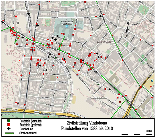
Deutsch: Bereich der Zivilsiedlung (Municipium) von Vindobona, Fundstellen von 1588 bis 2010.
Vorlage aus: Karin Fischer-Ausserer (Hrsgb.): Entlang des Rennweges. Die römische Zivilsiedung vom Vindobona, Wien Archäologisch, Band 8, Museen der Stadt Wien - Stadtarchäologie, Wien 2011. Reinhard Pohanka: Das römische Wien, Geschichte Wiens Band I, Pichler Verlag Ed. Wien, 1997, S. 21 |
| Date | |
| Source | Own work (Original text: eigene Arbeit) |
| Author | ©OpenStreetMap und Mitarbeiter, Ergänzung: Veleius / Veleius at German Wikipedia |
Licensing[edit]
This file is licensed under the Creative Commons Attribution-Share Alike 2.0 Generic license.
- You are free:
- to share – to copy, distribute and transmit the work
- to remix – to adapt the work
- Under the following conditions:
- attribution – You must give appropriate credit, provide a link to the license, and indicate if changes were made. You may do so in any reasonable manner, but not in any way that suggests the licensor endorses you or your use.
- share alike – If you remix, transform, or build upon the material, you must distribute your contributions under the same or compatible license as the original.
| This work contains information from OpenStreetMap, which is made available under the Open Database License (ODbL).
The ODbL does not require any particular license for maps produced from ODbL data. Prior to 1 August 2020, map tiles produced by the OpenStreetMap Foundation were licensed under the CC-BY-SA-2.0 license. Maps produced by other people may be subject to other licences. |
Original upload log[edit]
The original description page was here. All following user names refer to de.wikipedia.
| Date/Time | Dimensions | User | Comment |
|---|---|---|---|
| 2013-09-29 21:49 | 896×793× (1213545 bytes) | Veleius | {{Information |Beschreibung = Bereich der Zivilsiedlung (Municipium) von Vindobona, Fundstellen von 1588 bis 2010. |Quelle = eigene Arbeit |Urheber = ©[[OpenStreetMap]] und Mitarbeiter, Ergänzung: [[Benutzer:Veleius|Veleius]] |… |
File history
Click on a date/time to view the file as it appeared at that time.
| Date/Time | Thumbnail | Dimensions | User | Comment | |
|---|---|---|---|---|---|
| current | 10:48, 28 August 2014 | | 896 × 793 (1.16 MB) | Nachcommonsverschieber (talk | contribs) | Transferred from de.wikipedia |
You cannot overwrite this file.
File usage on Commons
There are no pages that use this file.
File usage on other wikis
The following other wikis use this file:
- Usage on de.wikipedia.org