File:GasDepositDiagram.svg
Jump to navigation
Jump to search

Size of this PNG preview of this SVG file: 755 × 525 pixels. Other resolutions: 320 × 223 pixels | 640 × 445 pixels | 1,024 × 712 pixels | 1,280 × 890 pixels | 2,560 × 1,780 pixels.
Original file (SVG file, nominally 755 × 525 pixels, file size: 105 KB)
Captions
Captions
Add a one-line explanation of what this file represents
Summary[edit]
| Description |
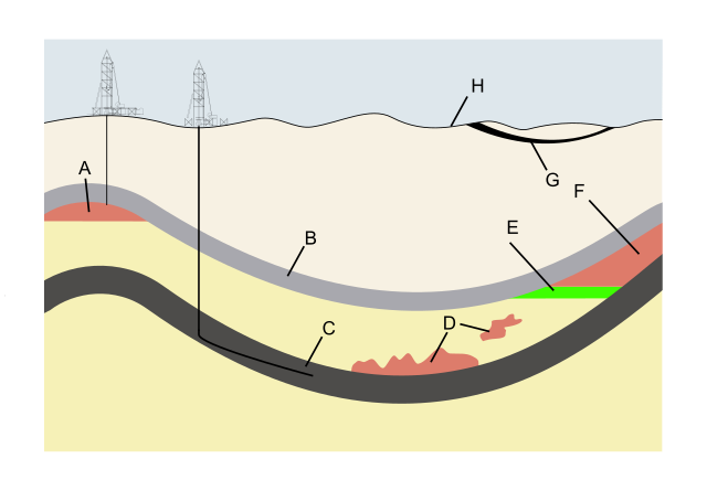
Deutsch: Schematischer Schnitt durch den Untergrund mit Darstellung verschiedener Erdgaslagerstättentypen
English: Schematic cross-section of the subsurface illustrating types of natural gas deposits
Русский: Schematic cross-section of the subsurface illustrating types of natural gas deposits
Polski: Złoża łupków gazowych w porównaniu do innych typów złóż gazu ziemnego |
| Date | (UTC) |
| Source | |
| Author |
Original uploader was Plazak at en.wikipedia |
| Other versions |
_Conventional_Deposits.svg) |
| This is a retouched picture, which means that it has been digitally altered from its original version. The original can be viewed here: GasDepositDiagram.jpg:
|
This work is in the public domain in the United States because it is a work prepared by an officer or employee of the United States Government as part of that person’s official duties under the terms of Title 17, Chapter 1, Section 105 of the US Code.
Note: This only applies to original works of the Federal Government and not to the work of any individual U.S. state, territory, commonwealth, county, municipality, or any other subdivision. This template also does not apply to postage stamp designs published by the United States Postal Service since 1978. (See § 313.6(C)(1) of Compendium of U.S. Copyright Office Practices). It also does not apply to certain US coins; see The US Mint Terms of Use.
|
 | |
| This file has been identified as being free of known restrictions under copyright law, including all related and neighboring rights. | ||
Original upload log[edit]
This image is a derivative work of the following images:
- File:GasDepositDiagram.jpg licensed with PD-USGov
- 2010-03-14T10:40:17Z Jo Weber 718x473 (49984 Bytes) {{Information |Description={{en|Schematic cross-section of the subsurface illustrating types of natural gas deposits}} |Source=Transferred from [http://en.wikipedia.org en.wikipedia] (Original text : ''US Energy Information A
Uploaded with derivativeFX
File history
Click on a date/time to view the file as it appeared at that time.
| Date/Time | Thumbnail | Dimensions | User | Comment | |
|---|---|---|---|---|---|
| current | 08:11, 3 August 2010 | | 755 × 525 (105 KB) | Marek Mazurkiewicz (talk | contribs) | {{Information |Description={{en|Schematic cross-section of the subsurface illustrating types of natural gas deposits}} {{pl|Złoża łupków gazowych w porównaniu do innych typów złóż gazu ziemnego}} |Source=*File:GasDepositDiagram.jpg |Date=20 |
You cannot overwrite this file.
File usage on Commons
The following page uses this file:
File usage on other wikis
The following other wikis use this file:
- Usage on ca.wikipedia.org
- Usage on cv.wikipedia.org
- Usage on es.wikipedia.org
- Usage on ja.wikipedia.org
- Usage on pl.wikipedia.org
- Usage on pl.wikiquote.org
- Usage on ru.wikipedia.org