File:Gbcounties.png

Original file (797 × 1,264 pixels, file size: 88 KB, MIME type: image/png)
Captions
Captions
Summary[edit]
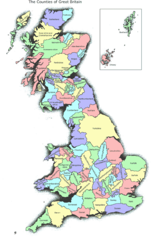
Historical map of Great Britain, originally from www.abcounties.co.uk
The purpose of this map is to give a reasonably accurate large-scale representation of the 86 'traditional' counties of Britain as they existed before 1974. No claim to small-scale planimetric accuracy is made. For the sake of convenience and practicality only the greatest detached parts (exclaves) are shown (in descending size order, those of Lancashire (i.e. Furness), Flintshire (3), Dunbartonshire and Worcestershire (2)). All other detached parts are shown as part of the county surrounding them. Due to the fragmentary nature of Cromartyshire, it is shown as a single geographical area with Ross-shire, the combined area being labelled "Ross-shire and Cromartyshire".
The map may be copied and used freely. However, the Association of British Counties would appreciate an acknowledgement and a link to our site.
Copied from the Swedish Wikipedia, there uploaded by Rudolf 1922 11 april 2004 kl. 18.35.
Licensing[edit]

|
The copyright holder of this work allows anyone to use it for any purpose including unrestricted redistribution, commercial use, and modification.
Usage notes:
|
File history
Click on a date/time to view the file as it appeared at that time.
| Date/Time | Thumbnail | Dimensions | User | Comment | |
|---|---|---|---|---|---|
| current | 16:01, 7 November 2006 | | 797 × 1,264 (88 KB) | Boivie (talk | contribs) | Historical map of Great Britain, originally from [http://www.abcounties.co.uk/ www.abcounties.co.uk] The purpose of this map is to give a reasonably accurate large-scale representation of the 86 Counties of Britain. No claim to small-scale planimetric ac |
You cannot overwrite this file.
File usage on Commons
There are no pages that use this file.
File usage on other wikis
The following other wikis use this file:
- Usage on en.wikipedia.org
- User:Lewisdg2000
- User:Owain
- User:M A Mason
- User:El Pollo Diablo
- User:Bayerischermann
- User:LUNDAVRA
- Template:User British Counties
- User:Heavens To Betsy
- User:Sigurd Dragon Slayer
- User:GSTQ
- User:Marsbar man
- User:White43
- User:Bailrigg
- User:Gal Lass
- User:Ausbusinessnetwork
- User:Tangerines/Userboxes
- User:Gladius Terrae Novae
- User:03md
- User:Tinbath
- User:Arcturus
- User:AssociateAffiliate
- User:Tuckerresearch/UserBoxes
- User:PuritanMoshPit
- Wikipedia:Userboxes/Politics by country/United Kingdom
- User:Qazwsx777
- User:Chocolateediter
- User:Thornfield Hall