File:GoTransitTrainMap-Chinese.png
Jump to navigation
Jump to search
Size of this preview: 800 × 486 pixels. Other resolutions: 320 × 194 pixels | 640 × 389 pixels | 1,024 × 622 pixels | 1,580 × 960 pixels.
Original file (1,580 × 960 pixels, file size: 91 KB, MIME type: image/png)
Captions
Captions
Add a one-line explanation of what this file represents
| Description |
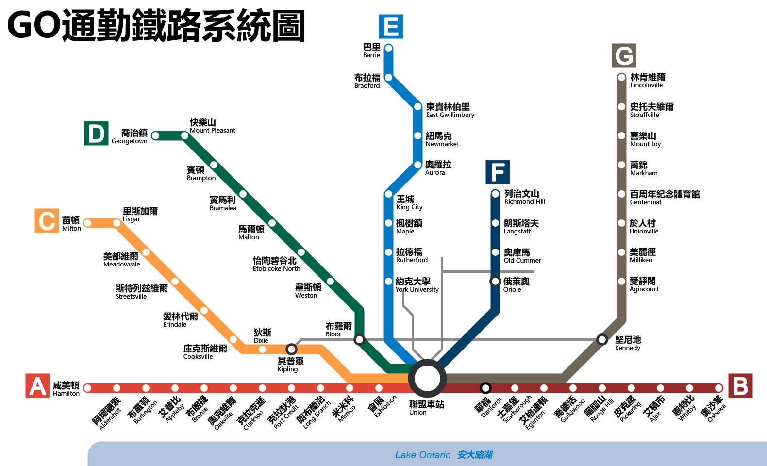
English: A map of the en:GO Transit commuter rail service Deutsch: Streckenplan der de:GO Transit mit den Linien A-G Español: Mapa del sistema es:GO Train. Français : Carte du système de train GO Português: Sistema de trens do pt:GO Transit. 中文:zh:GO運輸通勤鐵路系統圖。 |
| Date | (UTC) |
| Source | |
| Author |
|
| This is a retouched picture, which means that it has been digitally altered from its original version. Modifications: Traditional Chinese translations added.. The original can be viewed here: GoTransitTrainMap.png:
|
I, the copyright holder of this work, hereby publish it under the following licenses:
This file is licensed under the Creative Commons Attribution-Share Alike 3.0 Unported license.
- You are free:
- to share – to copy, distribute and transmit the work
- to remix – to adapt the work
- Under the following conditions:
- attribution – You must give appropriate credit, provide a link to the license, and indicate if changes were made. You may do so in any reasonable manner, but not in any way that suggests the licensor endorses you or your use.
- share alike – If you remix, transform, or build upon the material, you must distribute your contributions under the same or compatible license as the original.

|
Permission is granted to copy, distribute and/or modify this document under the terms of the GNU Free Documentation License, Version 1.2 or any later version published by the Free Software Foundation; with no Invariant Sections, no Front-Cover Texts, and no Back-Cover Texts. A copy of the license is included in the section entitled GNU Free Documentation License. |
You may select the license of your choice.
Original upload log[edit]
This image is a derivative work of the following images:
- File:GoTransitTrainMap.png licensed with Cc-by-sa-3.0, GFDL
- 2009-04-25T14:18:11Z Vidioman 1580x960 (174294 Bytes) {{Information |Description={{en|1=go transit map}} |Source=Own work by uploader |Author=[[User:Vidioman|Vidioman]] |Date=2009-04-25 |Permission= |other_versions=File:GoTransitTrainMap.svg }}
Uploaded with derivativeFX
File history
Click on a date/time to view the file as it appeared at that time.
| Date/Time | Thumbnail | Dimensions | User | Comment | |
|---|---|---|---|---|---|
| current | 20:24, 4 July 2015 | | 1,580 × 960 (91 KB) | Cmdrjameson (talk | contribs) | Compressed with pngout. Reduced by 61kB (40% decrease). |
| 21:38, 22 August 2010 |  | 1,580 × 960 (152 KB) | Hinto (talk | contribs) | Somehow the older version didn't show up. | |
| 21:35, 22 August 2010 |  | 1,580 × 960 (152 KB) | Hinto (talk | contribs) | {{Information |Description={{en|1=A map of the en:GO Transit commuter rail service}} {{de|1=Streckenplan der de:GO Transit mit den Linien A-G}} {{es|1=Mapa del sistema es:GO Train.}} {{fr|1=Carte du système de train GO}} { |
You cannot overwrite this file.
File usage on Commons
The following 3 pages use this file: