File:Gravel Rivers in Northeastern Italy.jpg
Jump to navigation
Jump to search
Size of this preview: 476 × 600 pixels. Other resolutions: 190 × 240 pixels | 381 × 480 pixels | 609 × 768 pixels | 813 × 1,024 pixels | 1,625 × 2,048 pixels | 3,199 × 4,031 pixels.
Original file (3,199 × 4,031 pixels, file size: 4.2 MB, MIME type: image/jpeg)
Captions
Captions
Add a one-line explanation of what this file represents
Summary[edit]
| Description |
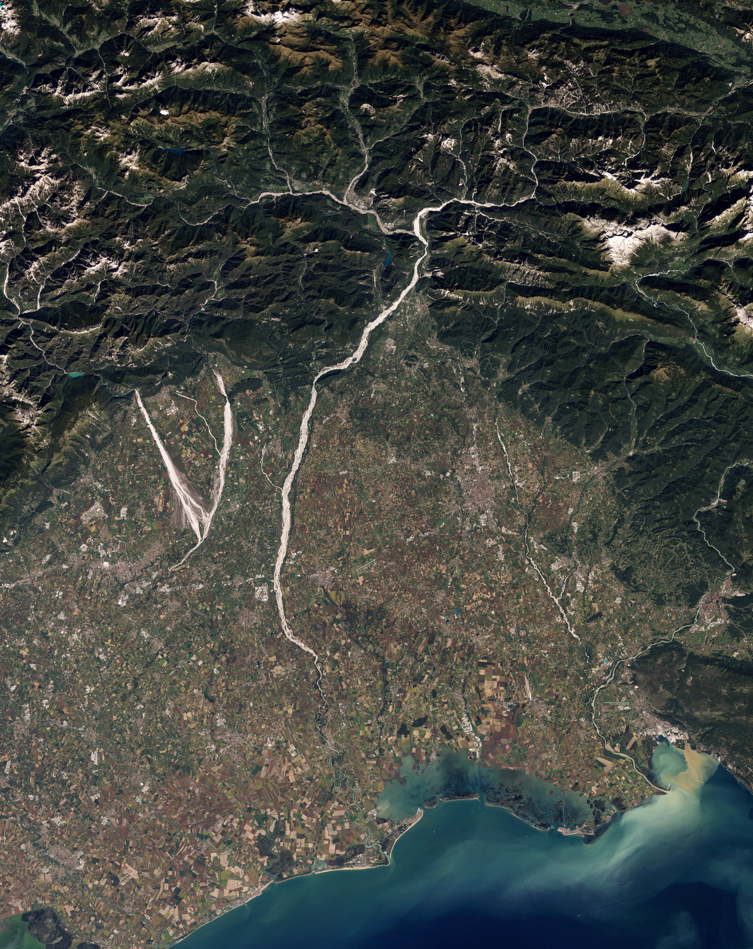
English: Natural-colour image of north-eastern Italy showing parts of the Cellina, Meduna, and Tagliamento rivers. The gravel-coated riverbeds contrast sharply with the surrounding landscape, highlighting the river contours. The Cellina and Meduna Rivers converge in the south, forming a giant V shape. When a river receives more sediment than it can move effectively, the river changes shape, often carving braided channels. Upstream from the Cellina, Meduna, and Tagliamento Rivers, the mountain basin is seismically active and prone to landslides. As a result, heavy sediment loads often reach these rivers, all three of which have braided channels.
Around the rivers, rectangular shapes of green, gold, and brown belong to cultivated fields. The crops mingle with settlements, some of them quite close to river channels. Some hydrologists have expressed concern about continued development on this floodplain because flood damage has occurred fairly frequently, just as the fertile soils have attracted farmers.
Italiano: Immagine a colori naturali del nord-est dell'Italia (Regione Friuli-Venezia Giulia) che mostra i torrenti Cellina e Meduna ed il fiume Tagliamento. I letti ghiaiosi di questi corsi d'acqua contrastano con il terreno circostante, rendendoli immediatamente riconoscibili. Il Cellina ed il Meduna formano alla loro confluenza la grande V sulla sinistra.
Il grande accumulo di materiale ghiaioso è dovuto anche all'instabilità idrogeologica e tettonica dei bacini montani di questi fiumi: nel caso del Tagliamento di conseguenza si è sviluppata una morfologia fluviale a canali intrecciati (braided). La dinamica naturale qui visibile è messa a rischio dalla costruzione di dighe (principalmente nel caso del Cellina), dal prelievo di ghiaia, dal trattenimento dei sedimenti a monte, e dallo sviluppo di coltivazioni ed insediamenti all'interno dell'alveo naturale. |
| Date | |
| Source | NASA Earth Observatory |
| Author | Robert Simmon |
Image captured by the Thematic Mapper on NASA’s Landsat 5 satellite. Data provided by the United States Geological Survey.
Licensing[edit]
| This file is in the public domain in the United States because it was solely created by NASA. NASA copyright policy states that "NASA material is not protected by copyright unless noted". (See Template:PD-USGov, NASA copyright policy page or JPL Image Use Policy.) | ||
 |
Warnings:
|
| Annotations | This image is annotated: View the annotations at Commons |
File history
Click on a date/time to view the file as it appeared at that time.
| Date/Time | Thumbnail | Dimensions | User | Comment | |
|---|---|---|---|---|---|
| current | 10:13, 13 December 2010 | | 3,199 × 4,031 (4.2 MB) | Originalwana (talk | contribs) | {{Information |Description={{en|1=Natural-colour image of north-eastern Italy showing parts of the Cellina, Meduna, and Tagliamento rivers. The gravel-coated riverbeds contrast sharply with the surrounding landscape, highlighting the |
You cannot overwrite this file.
File usage on Commons
The following page uses this file:
File usage on other wikis
The following other wikis use this file:
- Usage on ar.wikipedia.org
- Usage on ca.wikipedia.org
- Usage on de.wikipedia.org
- Usage on en.wikipedia.org
- Usage on eo.wikipedia.org
- Usage on hy.wikipedia.org
- Usage on it.wikipedia.org
- Usage on it.wikiquote.org
- Usage on no.wikipedia.org
- Usage on oc.wikipedia.org
- Usage on os.wikipedia.org
- Usage on ru.wikipedia.org
- Usage on uk.wikipedia.org
- Usage on vec.wikipedia.org
- Usage on www.wikidata.org