File:Grenoble Tassin 1638.jpg
Jump to navigation
Jump to search

Size of this preview: 800 × 544 pixels. Other resolutions: 320 × 218 pixels | 640 × 435 pixels | 1,024 × 696 pixels | 1,280 × 870 pixels | 1,812 × 1,232 pixels.
Original file (1,812 × 1,232 pixels, file size: 1.12 MB, MIME type: image/jpeg)
Captions
Captions
Add a one-line explanation of what this file represents
Summary[edit]
| Description |
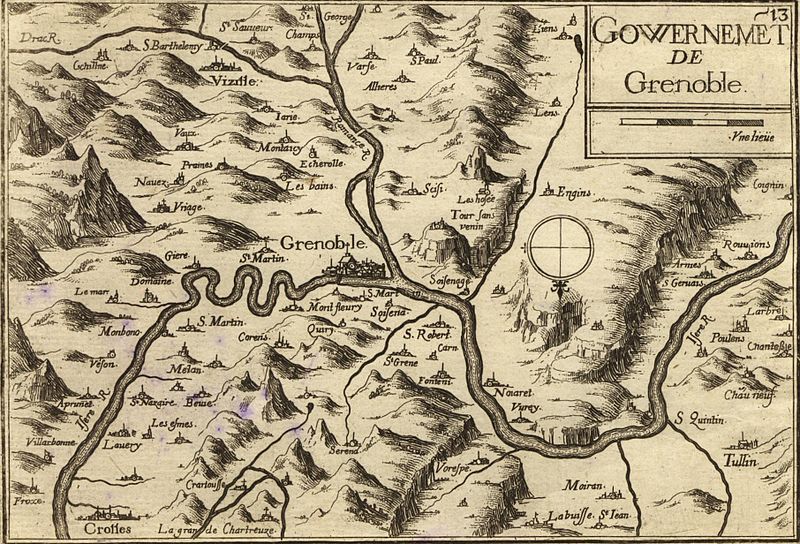
Français : Carte géographique ancienne de la région de Grenoble (Isère - Dauphiné - France) par Tassin aux alentours de 1638).
Il est intéressant de noter l'orientation inhabituelle Sud - Nord de cette carte ainsi que la toponymie très différente de celle d'aujourd'hui. Ainsi par exemple, Meylan était alors orthographié Mélan. A noter l'inversion entre Drac et Romanche
English: Old map of Grenoble area (Dauphiné - Isère - France) by Tassin circa 1638. Of interest is the unconventional South-North orientation of this map as well as the different toponomy. For example, Meylan is shown as "Mélan" on the map. Note that the rivers Drac and Romanche are inverted |
| Date | |
| Source | |
| Author | Tassin (reproduit par histoirepostale.net) |
| Camera location | | View this and other nearby images on: OpenStreetMap |
|---|
Licensing[edit]
|
This is a faithful photographic reproduction of a two-dimensional, public domain work of art. The work of art itself is in the public domain for the following reason:
The official position taken by the Wikimedia Foundation is that "faithful reproductions of two-dimensional public domain works of art are public domain".
This photographic reproduction is therefore also considered to be in the public domain in the United States. In other jurisdictions, re-use of this content may be restricted; see Reuse of PD-Art photographs for details. | ||||
File history
Click on a date/time to view the file as it appeared at that time.
| Date/Time | Thumbnail | Dimensions | User | Comment | |
|---|---|---|---|---|---|
| current | 07:43, 21 April 2008 | | 1,812 × 1,232 (1.12 MB) | Dlebouc (talk | contribs) | {{Information |Description= |Source= |Date= |Author= |Permission= |other_versions= }} |
| 08:41, 3 February 2008 |  | 1,812 × 1,232 (1.12 MB) | Dlebouc (talk | contribs) | == Description == {{Information |Description= {{fr|Carte géographique ancienne de la Tunisie par Vuillemin,Thuilier, Lacoste et Lorsignol (Paris 1902).}} {{en|Map of Tunisia by Vuillemin,Thuilier, Lacoste et Lorsignol (Paris 1902.}} |Source= {{fr|[http:/ |
You cannot overwrite this file.
File usage on Commons
The following page uses this file:
File usage on other wikis
The following other wikis use this file:
- Usage on en.wikipedia.org
- Usage on et.wikipedia.org
- Usage on frp.wikipedia.org
- Usage on fr.wikipedia.org
- Usage on ja.wikipedia.org
- Usage on nn.wikipedia.org
- Usage on oc.wikipedia.org
- Usage on ro.wikipedia.org
- Usage on sk.wikipedia.org