File:GrosseSeekarspitzePano.jpg
Jump to navigation
Jump to search

Size of this preview: 800 × 96 pixels. Other resolutions: 320 × 38 pixels | 640 × 77 pixels.
Original file (4,997 × 600 pixels, file size: 987 KB, MIME type: image/jpeg)
Captions
Captions
Add a one-line explanation of what this file represents
Summary[edit]
| Description |
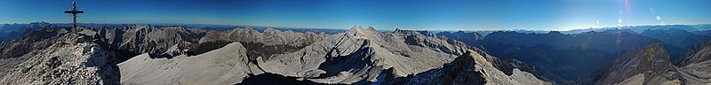
English: Panoramic view from Große Seekarspitze (Karwendel) to Birkkarspitze (view annotations) and mountains in the main chain. Birkköpfe in the South of Ödkarspitze. Northern ridge of Karwendel in the left half of the photo (from far, beyond Karwendel valley), with the Kuhkopf, optical near the 3 Ödkarspitzen and Birkkarspitze. A far view to Zugspitze and Wetterstein in the West (left). The dark blue green valley in the right side is Hinterautal (upper oberste Isar), the lower steep blue mountain ridge Roßlochkamm (Gamskarspitze, Brantlspitze rise up from Roßloch-Alm. |
| Date | |
| Source | photo taken by Kogo |
| Author | Kogo |
| Permission (Reusing this file) |
Kogo put it under the GFDL |
| Camera location | | View this and other nearby images on: OpenStreetMap |
|---|

|
Permission is granted to copy, distribute and/or modify this document under the terms of the GNU Free Documentation License, Version 1.2 or any later version published by the Free Software Foundation; with no Invariant Sections, no Front-Cover Texts, and no Back-Cover Texts. A copy of the license is included in the section entitled GNU Free Documentation License. |
| Annotations | This image is annotated: View the annotations at Commons |


.jpg)
File history
Click on a date/time to view the file as it appeared at that time.
| Date/Time | Thumbnail | Dimensions | User | Comment | |
|---|---|---|---|---|---|
| current | 16:13, 19 November 2005 | 4,997 × 600 (987 KB) | Kogo (talk | contribs) |
You cannot overwrite this file.
File usage on Commons
The following 2 pages use this file:
File usage on other wikis
The following other wikis use this file:
- Usage on de.wikipedia.org
- Usage on en.wikipedia.org
- Usage on fr.wikipedia.org
- Usage on nl.wikipedia.org