File:Growing a way to self-sufficiency (5951349750).jpg

Original file (3,456 × 5,184 pixels, file size: 6.4 MB, MIME type: image/jpeg)
Captions
Captions
Summary[edit]
| DescriptionGrowing a way to self-sufficiency (5951349750).jpg |
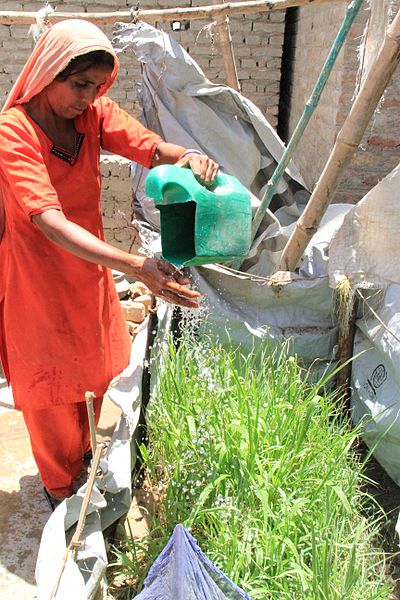
Sabiha Khatoon, from Sindh in Pakistan waters vegetables in a small garden plot next to her newly-built home in the village of Mehar Channa. The village was devastated by the floods last year, with most of the mud (kichar) homes washed away and crops and livestock lost. People who lived in the village had to flee their homes when the flood waters arrived in the middle of the night, leaving everything behind and moving away to safer areas - some going to emergency tented camps and others going to stay with family in towns and cities across Sindh province. “In March we were approached by Concern about building a brick house for us. We had to show papers to prove the land was ours then they agreed to help build us a house. We are very happy about this because if Concern and DFID hadn’t helped us, we’d be in the hot sun in our tents. “We also received fertilizer and seeds, and new hand pumps. Clean water means it is now easy to get clean drinking water and we can wash our clothes daily, and we can grow seeds given to us. We are growing sagar, we will make bread from it. We are very thankful to people in the UK for the help they gave us.” To find out more about how the UK is helping in Pakistan, please visit: www.dfid.gov.uk/Media-Room/Features/2011/Pakistan-floods-... Image credit: Vicki Francis/Department for International Development Terms of use This image is posted under a Creative Commons - Attribution Licence, in accordance with the Open Government Licence. You are free to embed, download or otherwise re-use it, as long as you credit the source as 'Vicki Francis/Department for International Development'. |
| Date | |
| Source | Growing a way to self-sufficiency |
| Author | DFID - UK Department for International Development |
| Camera location | 27° 49′ 41.33″ N, 68° 16′ 18.44″ E | View this and other nearby images on: OpenStreetMap |
|---|
Licensing[edit]
- You are free:
- to share – to copy, distribute and transmit the work
- to remix – to adapt the work
- Under the following conditions:
- attribution – You must give appropriate credit, provide a link to the license, and indicate if changes were made. You may do so in any reasonable manner, but not in any way that suggests the licensor endorses you or your use.
| This image, originally posted to Flickr, was reviewed on 22 May 2013 by the administrator or reviewer File Upload Bot (Magnus Manske), who confirmed that it was available on Flickr under the stated license on that date. |
File history
Click on a date/time to view the file as it appeared at that time.
| Date/Time | Thumbnail | Dimensions | User | Comment | |
|---|---|---|---|---|---|
| current | 16:47, 22 May 2013 |  | 3,456 × 5,184 (6.4 MB) | File Upload Bot (Magnus Manske) (talk | contribs) | Transferred from Flickr by User:russavia |
You cannot overwrite this file.
File usage on Commons
There are no pages that use this file.
Metadata
This file contains additional information such as Exif metadata which may have been added by the digital camera, scanner, or software program used to create or digitize it. If the file has been modified from its original state, some details such as the timestamp may not fully reflect those of the original file. The timestamp is only as accurate as the clock in the camera, and it may be completely wrong.
| Camera manufacturer | Canon |
|---|---|
| Camera model | Canon EOS 7D |
| Exposure time | 1/640 sec (0.0015625) |
| F-number | f/14 |
| ISO speed rating | 2,500 |
| Date and time of data generation | 12:01, 8 June 2011 |
| Lens focal length | 20 mm |
| Copyright holder | Crown Copyright/Open Government License |
| Image title | Flood-affected people in Sindh, Pakistan, recipients of UK humanitarian aid in response to the 2010 floods. |
| Author | DFID/Vicki Francis |
| Credit/Provider | DFID/Vicki Francis |
| Orientation | Normal |
| Horizontal resolution | 72 dpi |
| Vertical resolution | 72 dpi |
| File change date and time | 12:01, 8 June 2011 |
| Exposure Program | Normal program |
| Exif version | 2.21 |
| Date and time of digitizing | 12:01, 8 June 2011 |
| APEX shutter speed | 9.375 |
| APEX aperture | 7.625 |
| APEX exposure bias | 0 |
| Metering mode | Spot |
| Flash | Flash did not fire, compulsory flash suppression |
| DateTime subseconds | 31 |
| DateTimeOriginal subseconds | 31 |
| DateTimeDigitized subseconds | 31 |
| Supported Flashpix version | 1 |
| Color space | sRGB |
| Focal plane X resolution | 5,715.5454545455 |
| Focal plane Y resolution | 5,808.4035087719 |
| Focal plane resolution unit | inches |
| Custom image processing | Normal process |
| Exposure mode | Auto exposure |
| White balance | Auto white balance |
| Scene capture type | Standard |
| IIM version | 2 |
| Country shown | Pakistan |
| Province or state shown | Sindh |
| Keywords |
|